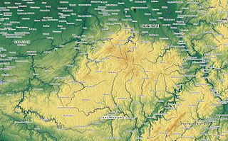
Euskirchen is a Kreis (district) in the south-west of North Rhine-Westphalia, Germany. Neighboring districts are Aachen, Düren, Rhein-Erft-Kreis, Rhein-Sieg, Ahrweiler, Daun, Bitburg-Prüm, and the Liège province (Belgium).
Ahrweiler is a district in the north of Rhineland-Palatinate, Germany. It is bounded by the districts of Euskirchen, Rhein-Sieg and the city of Bonn in the state of North Rhine-Westphalia, and the districts of Neuwied, Mayen-Koblenz and Vulkaneifel.

The Eifel is a low mountain range in western Germany, eastern Belgium and northern Luxembourg. It occupies parts of southwestern North Rhine-Westphalia, northwestern Rhineland-Palatinate and the southern area of the German-speaking Community of Belgium.

Ahr is a river in Germany, a left tributary of the Rhine. Its source is at an elevation of approximately 470 metres (1,540 ft) above sea level in Blankenheim in the Eifel, in the cellar of a timber-frame house near the castle of Blankenheim. After 18 kilometres (11 mi) it crosses from North Rhine-Westphalia into Rhineland-Palatinate.

Meckenheim is a town in the Rhein-Sieg district, in North Rhine-Westphalia, Germany.

Rheinbach is a town in the Rhein-Sieg-Kreis district (Landkreis), in North Rhine-Westphalia, Germany. It belongs to the administrative district (Regierungsbezirk) of Cologne.

The Swist is a stream, 43.6 kilometres (27.1 mi) long, in the German Rhineland. It rises on the northern edge of the Eifel at 330 metres above sea level and empties from the right and southeast into the Rhine tributary, the Erft, between Weilerswist and Bliesheim. Occasionally the Swist is also called the Swistbach, and locals often just call it der Bach.

Odendorf is a village in Germany, located in the municipality of Swisttal in the Rhein-Sieg district of North Rhine-Westphalia. The village is situated approximately 20 km (12 mi) southwest of Bonn. As of 2007, the village had 3,581 inhabitants.

Flerzheim is a part (Stadtteil) of Rheinbach in the Rhein-Sieg-Kreis in North Rhine-Westphalia, Germany.

The Ahr Hills are a range of low mountains and hills up to 623.8 m above sea level (NHN) and 25 kilometres (16 mi) long in the Eifel region of Germany, which lie roughly southwest of Bonn on the border between the German states of North Rhine-Westphalia and Rhineland-Palatinate.
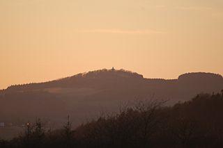
The Aremberg is, at 623 m above sea level (NN), the highest mountain in the Ahr Hills or Ahr Eifel (Ahreifel). It lies in the district of Ahrweiler, Rhineland-Palatinate (Germany).

The Ahr Valley Railway, Remagen–Ahrbrück, is currently a 29 km-long, partly single-track and non-electrified branch line, which runs through the Ahr valley from Remagen via Ahrweiler and Dernau to Ahrbrück in the German state of Rhineland-Palatinate. It is served by Regionalbahn services on lines RB 30 and RB 39.

The Voreifel Railway is a partly double track, non-electrified main line in the Voreifel from Bonn to Euskirchen in the German state of North Rhine-Westphalia.
The Michelsberg, at 586.1 m above sea level (NHN), is the highest point in the borough of Bad Münstereifel in the county of Euskirchen in the German state of North Rhine-Westphalia. The hill, which rises near the village of Mahlberg belongs to that part of the Eifel mountains known as the Ahr Hills (Ahreifel), and is the second highest point in the range.

The Hochthürmerberg, is a hill, 499.9 m above sea level (NHN), in the Eifel region. It is situated in the county of Euskirchen in North Rhine-Westphalia near the state border with Rhineland-Palatinate in Deutschland.
The Eifelgau was a Frankish gau in the region of the present day Limestone Eifel in Germany.
Arloff is a village in the borough of Bad Münstereifel in the district of Euskirchen in the German state of North Rhine-Westphalia.

The Häuschen is a hill, 506.5 m above sea level (NHN), in the Eifel mountains. It rises near Ahrweiler in the county of Ahrweiler in the German state of Rhineland-Palatinate.

The Teufelsley is a hill, 495.9 m above sea level (NHN), in the East Eifel, a region of the Eifel mountains in Germany. It is located near Liers in the county of Ahrweiler in the state of Rhineland-Palatinate and consists of the largest contiguous quartzite block in Europe.
The Eifel dialects are those dialects spoken in the Eifel mountains of Germany. They divide into two language regions: the dialects spoken in the southern Eifel (Eifelisch) are part of the Moselle Franconian dialect group and closely resemble Luxembourgish. In the northern Eifel, by contrast, the dialects (Eifelplatt) belong to the Ripuarian dialect group and are more like Öcher Platt or Kölsch. In between there is a dialect continuum of typical transitions, whereby more or less every village speaks a little differently from its neighbours.

