
Gitega is one of the 18 provinces of Burundi. Its capital is Gitega, which is also the national capital. It has a population of 725,223 as of 2008 and an area of 1,979 square kilometres (764 sq mi).

Bururi is a city located in southern Burundi. It is the capital city of Bururi Province and has around 20.000 inhabitants in 2007.

The Albertine Rift is the western branch of the East African Rift, covering parts of Uganda, the Democratic Republic of the Congo (DRC), Rwanda, Burundi and Tanzania. It extends from the northern end of Lake Albert to the southern end of Lake Tanganyika. The geographical term includes the valley and the surrounding mountains.
The Albertine Rift montane forests is a tropical moist broadleaf forest ecoregion in east-central Africa. The ecoregion covers the mountains of the northern Albertine Rift, and is home to distinct Afromontane forests with high biodiversity.

The wildlife of Burundi is composed of its flora and fauna. The small, landlocked country is home to 2,950 species of plants, 596 birds, 163 species of vertebrates, 52 species of reptiles, 56 species of amphibians, and 215 fish species. The wildlife has been drastically reduced in recent years, mainly on account of intense population pressure, conversion of large areas of forest into agricultural land, and extensive livestock farming. The protected area encompasses little more than 5% of the total area of the country.
Cardioglossa cyaneospila is a species of frog in the family Arthroleptidae. It is endemic to the Albertine Rift area in eastern Democratic Republic of the Congo, southwestern Uganda, Rwanda, and southwestern Burundi. It was described in 1950 by Raymond Laurent based on specimens collected in 1949. No new records were published until 2011. Recent research has uncovered both old unpublished records and several new records, and the conservation status was changed from "data deficient" to "near threatened" in 2016. Common names Bururi long-fingered frog and Mukuzira long-fingered frog have been coined for this species.
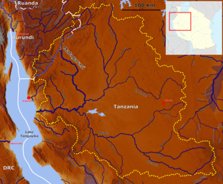
The Malagarasi River is a river in western Tanzania, flowing through Kigoma Region, although one of its tributaries comes from southeastern Burundi. It is the second-longest river in Tanzania behind the Rufiji—Great Ruaha, and has the largest watershed of any river flowing into Lake Tanganyika. The Malagarasi-Muyovozi Wetlands are a designated a Ramsar site. Local tribes have nicknamed the Malagarasi as "the river of bad spirits".
Burundi, officially the Republic of Burundi, is a landlocked country in the Great Rift Valley where the African Great Lakes region and East Africa converge. It is bordered by Rwanda to the north, Tanzania to the east and southeast, and the Democratic Republic of the Congo to the west; Lake Tanganyika lies along its southwestern border. The capital cities are Gitega and Bujumbura.

Following independence, the World Health Organization (WHO) assisted in the organization of public health services and the training of sanitarians and public health nurses for Burundi. Students from Burundi received medical training at universities in France and in the Democratic Republic of the Congo. WHO coordinated all public health programs and helped in campaigns against smallpox, tuberculosis, and malaria.
The commune of Bururi is a commune of Bururi Province in south-western Burundi. The capital lies at Bururi. In 2007, DGHER electrified one rural village in the commune.
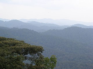
The commune of Vyanda is a commune of Bururi Province in south-western Burundi. The capital lies at Vyanda. It contains the Vyanda Forest Nature Reserve.
Buta is a small town in the Commune of Bururi in Bururi Province in southern Burundi. It is located 106 km by road southeast of Bujumbura and 11.3 km by R.N.16 and R.N.17 southeast of Bururi. A ten-minute drive from Bururi. Kruger writes wrongly that Buta is an important garrison town. During the civil war, there were a few kids in national service who were stationed there, to offer some protection to the seminary. On April 30, 1997, 44 Hutu and Tutsi seminarians were slaughtered at the minor seminary in Buta, most of whom were "Catholics of African origin: 8 from Rwanda, 6 from Congo, and 1 from Nigeria as well as the 4 from Burundi.".
Rwankona is a village in the Commune of Bururi in Bururi Province in southern Burundi. It is located just to the northwest of Buta.
Kiremba is a small town in the Commune of Bururi in Bururi Province in southern Burundi. By road it is located 7 kilometres southeast of Bururi and 4.3 kilometres northwest of Buta. On April 30, 1997, the same day as the massacre at nearby Buta, the FDD killed Hutu and two Tutsi people in Kiremba, burning the local hospital and raping two women before killing them. In 2004, the people were tested for epilepsy. Kiremba has a Swedish Protestant School, although it is said to be more Anglican in its teachings.
Murehe is a village in the Commune of Bururi in Bururi Province in southern Burundi. By road it is located 21.1 kilometres southeast of Bururi. Missionaries have been present in Murehe but the village is said to have "suffered" a shortage of them. During the genocide, the Minister of the Interior met at the dispensary in Murehe in a meeting on August 7, 1996.
Muyuga is a village in the Commune of Bururi in Bururi Province in southern Burundi. By road it is located 6.6 kilometres southeast of Bururi.
Binyuro is a village in the Commune of Vyanda in Bururi Province in southern Burundi. By road it is located 21 kilometres southeast of Bururi and 12.6 kilometres northwest of Vyanda, and south of Muyuga.
Rwira is an agricultural village in the Commune of Rutovu in Bururi Province in southern Burundi. It lies to the west of Rutovu. It is a place known for its bean production.
Rutovu is a small town and seat of the Commune of Rutovu in Bururi Province in southern Burundi. It lies 37.1 kilometres by road to the northeast of Bururi.

The Ikiza or the Ubwicanyi (Killings) was a series of mass killings—often characterised as a genocide—which were committed in Burundi in 1972 by the Tutsi-dominated army and government against the Hutus who lived in the country. Conservative estimates place the death toll of the event between 100,000 and 150,000 killed, while some estimates of the death toll go as high as 300,000.
