Wöllmisse

Last updated
Wöllmisse
Highest point
Elevation 405 m (1,329 ft)
Coordinates 50°54′37″N11°40′17″E / 50.91028°N 11.67139°E / 50.91028; 11.67139 Coordinates: 50°54′37″N11°40′17″E / 50.91028°N 11.67139°E / 50.91028; 11.67139
Geography
Location Jena, Thuringia, Germany
The Wollmisse near Jena-Lobeda, close to a well-known large-leaved linden Wollmisse bei Lobeda.JPG
The Wöllmisse near Jena-Lobeda, close to a well-known large-leaved linden

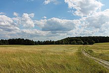
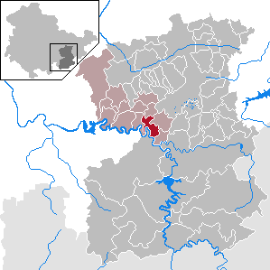
The Wöllmisse is a high plateau which rises east of the Saale Valley in the State of Thuringia, Germany. The densely wooded Wöllmisse borders the Roda Valley in the South, the Saale Valley to the West, the Gembdenbachtal in the North, and the town of Bürgel and the Gleistal Valley in the East. In Bürgel, it is connected via a saddle with the formation of Jenzig-Hufeisen-Alte Gleisberg.

Saale river in Germany

The Saale, also known as the Saxon Saale and Thuringian Saale, is a river in Germany and a left-bank tributary of the Elbe. It is not to be confused with the smaller Franconian Saale, a right-bank tributary of the Main, or the Saale in Lower Saxony, a tributary of the Leine.

States of Germany First-level administrative subdivisions of the Federal Republic of Germany

Germany is a federal republic consisting of sixteen states. Since today's Germany was formed from an earlier collection of several states, it has a federal constitution, and the constituent states retain a measure of sovereignty. With an emphasis on geographical conditions, Berlin and Hamburg are frequently called Stadtstaaten (city-states), as is the Free Hanseatic City of Bremen, which in fact includes the cities of Bremen and Bremerhaven. The remaining 13 states are called Flächenländer.

Thuringia State in Germany

Thuringia, officially the Free State of Thuringia, is a state of Germany.

Contents

Municipalities and districts that are within the Wöllmisse are (beginning in the North): Großlöbichau in the District of Kleinlöbichau; the Bürgel villages of Rodigast and Lucka; Schöngleina with Zinna; Schlöben with the towns of Mennewitz, Zöttnitz, Rabis, Fraitsch and Burgrabis; the Jena districts of Ilmnitz, Drackendorf, Lobeda, Wöllnitz, Ziegenhain, Camsdorf, Wenigen-Jena, Jenaprießnitz and Wogau. Also, the villages of Trockhausen, Gröben, and Podelsatz are considered a part of the Wöllmisse, all at the southern foot of the ridge.

Bürgel Place in Thuringia, Germany

Bürgel is a town in the Saale-Holzland district, in Thuringia, Germany. It is situated 12 km east of Jena.

Jena Place in Thuringia, Germany

Jena is a German university city and the second largest city in Thuringia. Together with the nearby cities of Erfurt and Weimar, it forms the central metropolitan area of Thuringia with approximately 500,000 inhabitants, while the city itself has a population of about 110,000. Jena is a centre of education and research; the Friedrich Schiller University was founded in 1558 and had 18,000 students in 2017 and the Ernst-Abbe-Fachhochschule Jena counts another 5,000 students. Furthermore, there are many institutes of the leading German research societies.

Ziegenhain Place in Rhineland-Palatinate, Germany

Ziegenhain is a municipality in the district of Altenkirchen, in Rhineland-Palatinate, Germany. It used to be part of the mayoralty of Weyerbusch.

Mountains

The Kernberge, seen from Jena-Winzerla Kernberg jena.png
The Kernberge, seen from Jena-Winzerla

In addition to the closed high plateau of the Wöllmisse, there are several mountains. The largest are the Kernberg and the Johannisberg to the West. They rise approximately 250 m above the Saale Valley.

History

In the southwest of the Wöllmisse is the ruin the first mentioned Castle at Jena, the Lobdeburg built in 1166.

During the Middle Ages the Wölmisse was almost completely clearcut and on its slopes vineyards operated. Since the last century it has been replanted once again. Today the Wöllmisse is an important recreational area for Jena.

Related Research Articles

Saale-Holzland-Kreis District in Thuringia, Germany

Saale-Holzland is a Kreis (district) in the east of Thuringia, Germany. Neighboring districts are the district Burgenlandkreis in Saxony-Anhalt, the district-free city Gera, the districts Greiz, Saale-Orla, Saalfeld-Rudolstadt, Weimarer Land and the district-free city Jena.

Rhön Mountains low mountain range in Germany

The Rhön Mountains are a group of low mountains in central Germany, located around the border area where the states of Hesse, Bavaria and Thuringia come together. These mountains, which are at the extreme southeast end of the East Hesse Highlands, are partly a result of ancient volcanic activity. They are separated from the Vogelsberg Mountains by the river Fulda and its valley. The highest mountain in the Rhön is the Wasserkuppe which is in Hesse. The Rhön Mountains are a popular tourist destination and walking area.

Saxe-Weimar-Eisenach grand duchy

Saxe-Weimar-Eisenach was created as a duchy in 1809 by the merger of the Ernestine duchies of Saxe-Weimar and Saxe-Eisenach, which had been in personal union since 1741. It was raised to a Grand duchy in 1815 by resolution of the Vienna Congress. In 1903, it officially changed its name to the Grand Duchy of Saxony, but this name was rarely used. The Grand Duchy came to an end in the German Revolution of 1918–19 with the other monarchies of the German Empire. It was succeeded by the Free State of Saxe-Weimar-Eisenach, which was merged into the new state of Thuringia two years later.

Saales Commune in Grand Est, France

Saales is a commune in the Bas-Rhin department in Grand Est in north-eastern France.

Camburg Quarter of Dornburg-Camburg in Thuringia, Germany

Camburg is a town in the Saale-Holzland district, in Thuringia, Germany. It is situated on the river Saale, 18 km northeast of Jena, and 13 km southwest of Naumburg. Since 1 December 2008, it is part of the town Dornburg-Camburg.

Neustadt an der Orla Place in Thuringia, Germany

Neustadt an der Orla is a town in Saale-Orla-Kreis district, in Thuringia. It is situated at the small river Orla, 17 km north of Schleiz, and 25 km southeast of Jena.

Ziegenrück Place in Thuringia, Germany

Ziegenrück is a town in the Saale-Orla-Kreis district, in southern Thuringia, Germany. It is situated on the river Saale, 22 km east of Saalfeld, and 35 km south of Jena.

Sparneck Place in Bavaria, Germany

Sparneck is a municipality in Upper Franconia in the district of Hof in Bavaria in Germany.

Albersdorf, Thuringia Place in Thuringia, Germany

Albersdorf is a municipality in the Saale-Holzland district of Thuringia, Germany.

Provenchères-sur-Fave Place in Grand Est, France

Provenchères-sur-Fave is a former commune in the Vosges department in northeastern France. On 1 January 2016, it was merged into the new commune Provenchères-et-Colroy. Inhabitants are called Provenchérois. Provenchères-sur-Fave should not be confused with Provenchères-lès-Darney in the same department.

Thuringian Highland mountain range

The Thuringian HighlandThuringian Highlands or Thuringian-Vogtlandian Slate Mountains is a low range of mountains in the German state of Thuringia.

Großheringen–Saalfeld railway railway line in Germany

The Großheringen–Saalfeld railway, also known as the Saalbahn, is a 153 kilometre-long double-track main line in the German state of Thuringia. It connects the Thuringian Railway at Großheringen with the Franconian Forest Railway at (Frankenwaldbahn) at Saalfeld and is part of the north-south main line, Munich–Nuremberg–Halle / Leipzig–Berlin. It is electrified at 15 kV. 16.7 Hz.

The Weimar–Gera railway is a line in the German state of Thuringia, connecting the city of Weimar via Jena, Stadtroda and Hermsdorf to Gera. It was built by the Weimar-Gera Railway Company, which was founded in June 1872, and the line was officially accepted into operation in June 1876.

Bürgel Abbey

Bürgel Abbey is a Benedictine monastery in the village of Thalbürgel of the town of Bürgel in Saale-Holzland-Kreis district in Thuringia in Germany.

Nauen Plateau

The Nauen Plateau is a low plateau in the German states of Brandenburg and Berlin. It rises above the surrounding countryside by an average of 15 metres (49 ft) and is a largely contiguous upland area that was formed during the Saale and Weichselian glaciations. It consists predominantly of ground moraine deposits, partly overlain by gently rolling end moraine formations. Whilst the neighbouring regions of Zauche to the south, the Teltow to the southeast and the Barnim to the northeast have the same name as their geological formation, the cultural landscape on the Nauen Plateau bears the historical and regional name of Havelland. That said, the river country of the Havelland extends beyond the plateau to include the Havel valley and other lowland areas.

Kulm (Saalfeld) mountain in Germany

The Kulm is a hill, 481.9 m above sea level (NHN), near Saalfeld in the German state of Thuringia. It lies east of the Saale valley at the western tip of the Saale 'Knee' and is the local hill of the towns of Saalfeld and Rudolstadt. From the Kulm there is a panoramic view over the valleys of the Saale and Rinne, the Orla Basin, the Thuringian Highland and the Ilm-Saale Plateau. Near the Kulm are the villages of Schloßkulm and Dorfkulm, which belong to the municipalities of Uhlstädt-Kirchhasel and Unterwellenborn respectively.

References