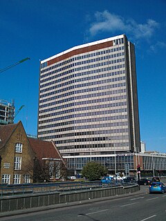
Taberner House housed the main offices of Croydon London Borough Council until September 2013; the building was demolished in 2015. It was located in Croydon, London, close to the Croydon Town Hall.
Nowe Żochy is a village in the administrative district of Gmina Nowe Piekuty, within Wysokie Mazowieckie County, Podlaskie Voivodeship, in north-eastern Poland.

Dębniak is a village in the administrative district of Gmina Zgierz, within Zgierz County, Łódź Voivodeship, in central Poland. It lies approximately 11 kilometres (7 mi) north of Zgierz and 19 km (12 mi) north of the regional capital Łódź.

Emilia is a village in the administrative district of Gmina Zgierz, within Zgierz County, Łódź Voivodeship, in central Poland. It lies approximately 10 kilometres (6 mi) north-west of Zgierz and 18 km (11 mi) north-west of the regional capital Łódź.

Gieczno is a village in the administrative district of Gmina Zgierz, within Zgierz County, Łódź Voivodeship, in central Poland. It lies approximately 15 kilometres (9 mi) north of Zgierz and 23 km (14 mi) north of the regional capital Łódź.

Janów is a village in the administrative district of Gmina Zgierz, within Zgierz County, Łódź Voivodeship, in central Poland. It lies approximately 6 kilometres (4 mi) north-east of Zgierz and 10 km (6 mi) north of the regional capital Łódź.

Skotniki is a village in the administrative district of Gmina Zgierz, within Zgierz County, Łódź Voivodeship, in central Poland. It lies approximately 5 kilometres (3 mi) east of Zgierz and 8 km (5 mi) north of the regional capital Łódź.

Szczawin Kościelny is a village in the administrative district of Gmina Zgierz, within Zgierz County, Łódź Voivodeship, in central Poland. It lies approximately 8 kilometres (5 mi) north-east of Zgierz and 13 km (8 mi) north of the regional capital Łódź.

Ukraina is a village in the administrative district of Gmina Zgierz, within Zgierz County, Łódź Voivodeship, in central Poland. It lies approximately 7 kilometres (4 mi) east of Zgierz and 10 km (6 mi) north of the regional capital Łódź.

Zimna Woda is a village in the administrative district of Gmina Zgierz, within Zgierz County, Łódź Voivodeship, in central Poland. It lies approximately 11 kilometres (7 mi) north-west of Zgierz and 19 km (12 mi) north-west of the regional capital Łódź.

Kiwajny is a village in the administrative district of Gmina Górowo Iławeckie, within Bartoszyce County, Warmian-Masurian Voivodeship, in northern Poland, close to the border with the Kaliningrad Oblast of Russia. It lies approximately 13 kilometres (8 mi) north-west of Górowo Iławeckie, 30 km (19 mi) north-west of Bartoszyce, and 66 km (41 mi) north of the regional capital Olsztyn.

Lục Bình is a commune (xã) and village in Bạch Thông District, Bắc Kạn Province, in Vietnam.

Lhotka is a village and municipality in Mělník District in the Central Bohemian Region of the Czech Republic.

Majiapu is a station on Line 4 of the Beijing Subway.

Bramfield is a village and civil parish in the East Hertfordshire district, in the county of Hertfordshire, England. Nearby settlements include Hertford, Waterford and Stapleford. Bramfield has a church dedicated to St Andrew.
Davulga is a village in the District of Emirdağ, Afyonkarahisar Province, Turkey.
Dereköy is a village in the District of Taşova, Amasya Province, Turkey.
Dragovishtitsa is a village in Kyustendil Municipality, Kyustendil Province, south-western Bulgaria.
Premćani is a village in the Pljevlja Municipality, in northern Montenegro. According to the 2003 census, the village had a population of 73 people. The village, a medieval site, was part of the medieval county of Tara. The monastery of Dovolja is located in the village.

The Rue de Charenton is a historic street in the 12th arrondissement of Paris, France. Several buildings along the street have been listed as official historical monuments by the French Ministry of Culture, namely numbers 23-25, number 35, numbers 49-51, numbers 59-61, and number 85 bis.


