Burkina Faso is a landlocked Sahel country that shares borders with six nations. It lies between the Sahara desert and the Gulf of Guinea, south of the loop of the Niger River, mostly between latitudes 9° and 15°N, and longitudes 6°W and 3°E. The land is green in the south, with forests and fruit trees, and semi-arid in the north. Most of central Burkina Faso lies on a savanna plateau, 198–305 metres (650–1,001 ft) above sea level, with fields, brush, and scattered trees. Burkina Faso's game preserves – the most important of which are Arly, Nazinga, and W National Park—contain lions, elephants, hippopotamus, monkeys, common warthogs, and antelopes. Previously the endangered painted hunting dog, Lycaon pictus occurred in Burkina Faso, but, although the last sightings were made in Arli National Park, the species is considered extirpated from Burkina Faso.

Benin, a narrow, key-shaped, north-south strip of land in West Africa, lies between the Equator and the Tropic of Cancer. Its altitude ranges from 6°30′ N to 12°30′ N and its longitude from 1° E to 3°40′ E. It is bounded by Togo to the west, Burkina Faso and Niger to the north, Nigeria to the east, and the Bight of Benin to the south.

A transboundary protected area (TBPA) is an ecological protected area that spans boundaries of more than one country or sub-national entity. Such areas are also known as transfrontier conservation areas (TFCAs) or peace parks.

Atakora is the northwesternmost department of Benin. Externally it borders Togo to the west and Burkina Faso to the north; internally it borders the departments of Alibori, Borgou and Donga. Major towns in the Atakora include Natitingou and Tanguiéta, and the major tourist areas include the Tata Somba houses, Pendjari National Park, and various waterfalls. The department of Atakora was bifurcated in 1999, with its southern territory removed to form the newly created Donga Department. The capital of Atakora Department is Natitingou; it is after the Atakora Mountains.
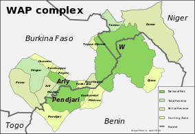
The W National Park or W Regional Park is a major national park in West Africa around a meander in the River Niger shaped like the letter W. The park includes areas of the three countries Niger, Benin and Burkina Faso, and is governed by the three governments. Until 2008, the implementation of a regional management was supported by the EU-funded project ECOPAS. The three national parks operate under the name W Transborder Park.. The section of W National Park lying in Benin, measuring over 8,000 km2 (3,100 sq mi), came under the full management of African Parks in June 2020. In Benin, W National Park is contiguous with Pendjari National Park which is also under the management of African Parks.

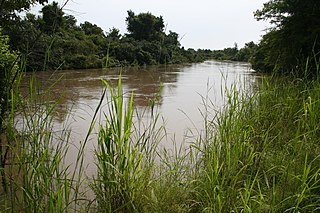
The Pendjari National Park lies in north western Benin, adjoining the Arli National Park in Burkina Faso. Named for the Pendjari River, the national park is known for its wildlife and is home to some of the last populations of big game like the African forest elephant, lion, hippopotamus, African buffalo, and various antelopes in West Africa. The park is also famous for its richness in birds.

The Oti River or Pendjari River is an international river in West Africa. It rises in Benin, forms the border between Benin and Burkina Faso, flows through Togo, and joins the Volta River in Ghana.
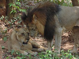
Panthera leo leo is a lion subspecies, which is present in West Africa, northern Central Africa and India. In West and Central Africa it is restricted to fragmented and isolated populations with a declining trajectory. It has been referred to as the Northern lion.

Arli National Park, often called Arly, is a national park located in Tapoa Province, southeastern Burkina Faso. It adjoins Benin's Pendjari National Park in the south and the Singou Reserve in the west.
Oti-Kéran National Park is located in the north of Togo, in the Kara area. There is only one road going through this area. Not many tourists visit Togo as the main national parks are more accessible in Ghana.
As of July 2021, there are a total of 1,154 World Heritage Sites located in 167 States Parties, of which 897 are cultural, 218 are natural and 39 are mixed properties. The countries have been divided by the World Heritage Committee into five geographic zones: Africa, Middle East, Asia and the Pacific, Europe and North America, and Latin America and the Caribbean. Italy, with 58 entries, has the highest number of World Heritage Sites. 27 state parties have no properties inscribed on the World Heritage List: Bahamas, Bhutan, Brunei, Burundi, Comoros, Cook Islands, Djibouti, Equatorial Guinea, Eswatini, Grenada, Guinea-Bissau, Guyana, Kuwait, Liberia, Maldives, Monaco, Niue, Rwanda, Saint Vincent and the Grenadines, Samoa, São Tomé and Príncipe, Sierra Leone, Somalia, South Sudan, Timor-Leste, Tonga, and Trinidad and Tobago.

The Northwest African cheetah, also known as the Saharan cheetah, is a cheetah subspecies native to the Sahara and the Sahel. It is listed as Critically Endangered on the IUCN Red List. In 2008, the population was suspected to number less than 250 mature individuals.

Burkina Faso is largely wild bush country with a mixture of grass and small trees in varying proportions. The savanna region is mainly grassland in the rainy season and semi desert during the harmattan period. Fauna, one of the most diverse in West Africa, includes the elephant, hippopotamus, buffalo, monkey, lions, crocodile, giraffe, various types of antelope, and a vast variety of bird and insect life. The country has 147 mammal species, 330 aquatic species including 121 species of fish and 2067 different plant species. Of the plant species, the dominant endemic species are shea tree (Butyrospermum parkii) and the baobab, the former plant species has immense economic value to the country.
Benin has varied resources of wildlife comprising flora and fauna, which are primarily protected in its two contiguous protected areas of the Pendjari National Park and W National Park. The former is known for many species of avifauna and the latter park is rich in mammals and predators. In addition, many other forest reserves are noted in the country but are not easily accessible, well protected or adequately surveyed for its wildlife resources. The protected area system of Benin defined as National Protected Area System is situated in the northern Benin, mostly with a woody savanna ecosystem. It covers 10.3% of the national territory and is part of the three nation transboundary W-Arly-Pendjari (WAP) complex.

Arly-Singou is a 6,388 km2 (2,466 sq mi) large ecosystem in Burkina Faso. It encompasses the Arli National Park and the Singou Reserve. It is considered to comprise part of the most significant and important savanna woodland wildlife areas still existing in West Africa.
Tourism in Benin is a small industry. In 1996, Benin had approximately 150,000 tourists. By 2014 number rose to 242,000. A small country with a high concentration of tourist attractions, Benin's national parks and culture are among its main tourist attractions. Abomey is one of Benin's main tourist attractions, with palaces that became a World Heritage Site in 1982. The capital city Porto Novo's attractions include its museums and architecture.

Pama Reserve is a partial reserve in Burkina Faso. Established in 1955 it is located in Kompienga Province and covers an area of 2237 km2. Its eastern border is the Singou river, separating it from two other reserves, Singou and Arli. The western border is the national road N18 from Fada N'Gourma to Porga. In the South the reserve reaches the Pendjari river, being Burkina Faso's border with Benin. The reserve is home to elephants, hippopotamuses, lions and leopards and 450 species of flowering plants.
Under UNESCO’s Man and the Biosphere Programme (MAB), there are 70 biosphere reserves recognized as part of the World Network of Biosphere Reserves in African States as of 2016. These are distributed across 28 countries. While biosphere reserves in West African, East African, Central African and Southern African countries are organised in the AfriMAB regional network, biosphere reserves in Northern African countries are organised in the ArabMAB, UNESCO's regional MAB network.

The Benin–Burkina Faso border is 386 km in length and runs from the tripoint with Togo in the southwest to the tripoint with Niger in the northeast.