
Mohave County occupies the northwestern corner of the U.S. state of Arizona. As of the 2020 census, its population was 213,267. The county seat is Kingman, and the largest city is Lake Havasu City. It is the fifth largest county in the United States.
Lake Mead National Recreation Area is a U.S. national recreation area in Southeastern Nevada and Northwestern Arizona. Operated by the National Park Service, Lake Mead NRA follows the Colorado River corridor from the westernmost boundary of Grand Canyon National Park to just north of the cities of Laughlin, Nevada and Bullhead City, Arizona. It includes all of the eponymous Lake Mead as well as the smaller Lake Mohave – reservoirs on the river created by Hoover Dam and Davis Dam, respectively – and the surrounding desert terrain and wilderness.

The Chocolate Mountains of California are located in Imperial and Riverside counties in the Colorado Desert of Southern California. The mountains stretch more than 60 miles (100 km) in a northwest to southeast direction, and are located east of the Salton Sea and south and west of the Chuckwalla Mountains and the Colorado River. To the northwest lie the Orocopia Mountains.
The Big Maria Mountains are located in the southeastern part of the U.S. state of California, near the Colorado River and Arizona. The range lies between Blythe and Vidal, and west of U.S. Route 95 in California and east of Midland. The mountains are home to the Eagle Nest Mine and reach an elevation of 1,030 m (3,380 ft). A power line that runs from Parker Dam to Yuma, Arizona runs through the range. A smaller range, the Little Maria Mountains, lie to the west of the Big Marias.

The Turtle Mountains, are located in northeastern San Bernardino County, in the southeastern part of California. The colorful Turtle Mountains vary from deep reds, browns, tans and grays, to black. The area has numerous springs and seeps. The Turtle Mountains are also a National Natural Landmark, with two mountain sections of entirely different composition.

The Fish Creek Mountains Wilderness is located about 25 miles west of Brawley, California, and southeast of the Vallecito Mountains in the United States. The wilderness is located in the Fish Creek Mountains region in the northern part of the Carrizo Impact Area, which is closed to the public.

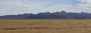
The Harquahala Mountains are the highest mountain range in southwestern Arizona, United States and are located southwest of the towns of Aguila and Wenden. The name originated from the Yavapai 'ʼHakhe:la", which means "running water". The range is oriented from northeast to southwest and is approximately 32 km long and 20 km at its widest point. At the northeast are two prominent peaks, Eagle Eye Peak and Eagle Eye Mountain. One has a natural opening or bridge through it appearing as an eye high up, and is the namesake for the peaks and Aguila. The highest point, Harquahala Peak, rises to 5,681 ft. Socorro Peak, 3270 ft, is at the southwest end of the range.

The 112,400-acre (45,500 ha) Warm Springs Wilderness makes up the entirety of the Black Mesa and parts of the surrounding foothills, washes, alluvial fans, and valleys. The Black Mesa is the southernmost section of the Black Mountains of western Mohave County, in northwest Arizona. The region is in the east and southeast of the Mojave Desert of Arizona, southern Nevada, and California.

The Muggins Mountains is a mountain range in southwest Arizona east of Yuma, Arizona, northeast of the Gila Mountains, and east of the Laguna Mountains. The Castle Dome Mountains lie to the northeast across the broad Castle Dome Plain. The Muggins Mountains Wilderness occupies the southwest portion of the range.
The Piper Mountain Wilderness is a federally designated wilderness area located in the White Mountains 20 miles (32 km) northeast of Big Pine, California in Inyo County, California.

The Santa Rosa Wilderness is a 72,259-acre (292.42 km2) wilderness area in Southern California, in the Santa Rosa Mountains of Riverside and San Diego counties, California. It is in the Colorado Desert section of the Sonoran Desert, above the Coachella Valley and Lower Colorado River Valley regions in a Peninsular Range, between La Quinta to the north and Anza Borrego Desert State Park to the south. The United States Congress established the wilderness in 1984 with the passage of the California Wilderness Act, managed by both the US Forest Service and the Bureau of Land Management. In 2009, the Omnibus Public Land Management Act was signed into law which added more than 2,000 acres (8.1 km2). Most of the Santa Rosa Wilderness is within the Santa Rosa and San Jacinto Mountains National Monument.
The Rawhide Mountains are a mountain range of western Arizona, in the southwest of Mohave County. It is part of a block of mountain ranges on the north of an insular region called the Maria fold and thrust belt, containing mountain ranges, valleys, and plains. The Rawhide Mountains border the much smaller Artillery Mountains southeast, bordering on Alamo Lake State Park and the south-flowing Big Sandy River.
The Aubrey Peak Wilderness is a 15,400-acre (6,230 ha) wilderness administered by the Bureau of Land Management (BLM). The wilderness is located in northwest Arizona in the southwest of Mohave County, a region of the southeastern Mojave Desert's extension into northwest Arizona.
The 5,080-acre (20.6 km2) Coyote Mountains Wilderness of Arizona is part of the Coyote Mountains of southern Arizona in the center of Pima County. The wilderness lies about 40 mi southwest of Tucson, in the northwest of the Altar Valley. Kitt Peak is 4 mi WSW.
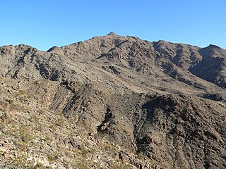
Mount Wilson is a mountain in Mohave County, Arizona, U.S. At 5,456 feet (1,663 m), it is the second highest point of the Black Mountains after Mount Perkins.
Gibraltar Mountain Wilderness is a protected wilderness area on the western edge of the Buckskin Mountains in the U.S. state of Arizona. Established in 1990 under the Arizona Desert Wilderness Act the area is managed by the Bureau of Land Management. This desert wilderness is primarily volcanic tuff crossed with deep canyons and sandy washes.
Woolsey Peak Wilderness is a protected wilderness area centered around its namesake Woolsey Peak, rising 2,500 feet to a summit at 3270 feet in the Gila Bend Mountains in the U.S. state of Arizona. Established in 1990 under the Arizona Desert Wilderness Act the area is managed by the Bureau of Land Management. This desert wilderness is best described as "a perfect example of pristine Sonoran Desert."
Signal Mountain Wilderness is a protected wilderness area centered around its namesake Signal Mountain, rising 1,200 feet (370 m) to a summit at 2,057 feet (627 m) in the Gila Bend Mountains in the U.S. state of Arizona. Established in 1990 under the Arizona Desert Wilderness Act, the area is managed by the Bureau of Land Management. The desert wilderness is made up of steep canyons, winding arroyos, and volcanic peaks within a Sonoran Desert ecosystem.
Table Top Wilderness is a protected wilderness area centered around its namesake Table Top Mountain, a summit of 4,373 feet in the Table Top Mountains in the U.S. state of Arizona. Established in 1990 under the Arizona Desert Wilderness Act the area is managed by the Bureau of Land Management. It is located in the Sonoran Desert National Monument south of Interstate 8 between the towns of Casa Grande and Gila Bend. The flat-topped mesa rises from the desert floor in Vekol Valley to the east surrounded by smaller canyons and desert washes with views of the desert plain in all directions. There are two established trails in the wilderness area, one of which leads to the summit.
Tres Alamos Wilderness is a protected wilderness area centered around the southern portion of the Black Mountains and the range high point of Sawyer Peak in the U.S. state of Arizona. The namesake feature, Tres Alamos, is a prominent and colorful monolith in the mountains. Established in 1990 under the Arizona Desert Wilderness Act the area is managed by the Bureau of Land Management.
