
The Kurobe Dam (黒部ダム) or Kuroyon Dam (黒四ダム), is a variable-radius arch dam on the Kurobe River in Toyama Prefecture, Japan. It supports the 335 MW Kurobe No. 4 Hydropower Plant and is owned by Kansai Electric Power Company. At 186 metres (610 ft) in height, it is the tallest dam in Japan. It was constructed between 1956 and 1963 at a cost of ¥51.3 billion yen. The project was a difficult engineering feat for the rapidly growing post–World War II Japan, and claimed the lives of 171 people.

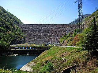
The Arimine Dam is located in Toyama, Toyama Prefecture, Japan built upon the Wada River. The two bends in the middle of the dam is the most defining feature. The Arimine Lake is an artificial lake that was created by construction of the dam.
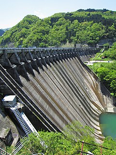
Miboro Dam is a dam on the Shō River in Shirakawa, in Gifu Prefecture Japan. It supports a 256 MW hydroelectric power station. Of the nine dams on the Shō River, it is the furthest upstream.

Sakaigawa Dam is a dam in Nanto, Toyama Prefecture and Shirakawa, Gifu Prefecture, Japan. It is named for the Sakaigawa River, upon which it is built. The dam has an associated 27 MW hydroelectric power station about 2.9 km (1.8 mi) downstream. It was commissioned in June 1993.

Toyama Bay is a bay located on the northern shores of the Hokuriku region Honshu, Japan on the Sea of Japan The bay borders Toyama and Ishikawa prefectures. The bay is known for the mirages on the horizon during the winter months and for being a spawning ground for the firefly squid. It is also one of Japan's three largest bays. Parts of the bay are within the borders of the Noto Hantō Quasi-National Park.
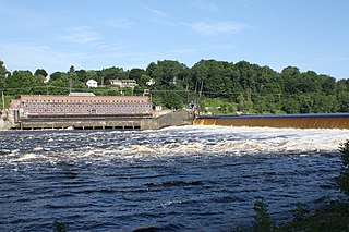
The Veazie Dam was a hydroelectric dam on the Penobscot River between Veazie and Eddington in Penobscot County, Maine. In 2010 the Penobscot River Restoration Trust bought the dam from PPL Corporation based on an agreement that was signed in 2004. Deconstruction of the dam began on July 22, 2013 as a part of an extensive project involving four dams to restore eleven species of sea-run fish to the Penobscot River. The Veazie Dam was the furthest downstream of the dams on the Penobscot River; now the Milford and Orono Dam dams are furthest downstream, albeit on separate side of Marsh Island. The Great Works Dam, which was 8 mi (13 km) upstream of the Veazie Dam, was removed in 2012.
The Komaki Dam is an arch-gravity dam on the Shō River about 2.5 km (1.6 mi) southeast of Shogawa in Toyama Prefecture, Japan. It was constructed between 1925 and 1930. The dam has an associated 90.2 MW hydroelectric power station which was commissioned in 1930. Of the nine dams on the Shō River it is the second-furthest downstream.

The Toga Dam is a gravity dam on the Togagawa River near Omaki village about 11 km (6.8 mi) southeast of Shogawa in Toyama Prefecture, Japan. It was constructed between 1941 and 1943. The dam diverts water to the 17.6 MW Omaki hydroelectric power station 4.3 km (2.7 mi) to the west on the Shō River. It was commissioned in 1944.

The Senzoku Dam is a gravity dam on the Togagawa River about 20 km (12 mi) south of Shogawa in Toyama Prefecture, Japan. It was completed in 1974. The dam sends water to the 32.7 MW Togagawa II hydroelectric power station 5.7 km (3.5 mi) to the west on the Shō River. It was commissioned in 1973.
The Togagawa Dam is a gravity dam on the Togagawa River near Taikanba village about 26 km (16 mi) southeast of Shogawa in Toyama Prefecture, Japan. It was completed in June 1974. The dam has an associated 16.1 MW hydroelectric power station 5.8 km (3.6 mi) downstream near the Senzoku Dam reservoir. It was commissioned in December 1973.

The Soyama Dam is a gravity dam on the Shō River in Soyama village about 13 km (8.1 mi) southeast of Nanto in Toyama Prefecture, Japan. It was constructed between 1927 and 1930. The dam has an associated 128.1 MW hydroelectric power station which was built in two parts. The first part of the power station was commissioned in 1930 and the second part of the power station was commissioned in 1967. Of the nine dams on the Shō River it is the third furthest downstream.

The Ohara Dam is a gravity dam on the Shō River in Ohara village about 17 km (11 mi) south of Nanto in Toyama Prefecture, Japan. It was constructed between 1939 and 1942. The dam has an associated 97.6 MW hydroelectric power station which was built in two parts. The first part of the power station was commissioned in 1942 and the second part of the power station was commissioned in 1980. Of the nine dams on the Shō River it is the fourth furthest downstream.

The Akao Dam is a gravity dam on the Shō River in Nishiakao village about 18 km (11 mi) south of Nanto in Toyama Prefecture, Japan. It was constructed between 1974 and 1978. The dam has an associated 34 MW hydroelectric power station which was commissioned in 1978. Of the nine dams on the Shō River it is the fifth furthest downstream.

The Narude Dam is a gravity dam on the Shō River about 22 km (14 mi) south of Nanto on the border of Toyama and Gifu Prefectures, Japan. It was constructed between 1950 and 1952. The dam has an associated 97 MW hydroelectric power station which was built in two parts. The first part of the power station was commissioned in 1951 and the second part of the power station was commissioned in 1975. Of the nine dams on the Shō River it is the sixth furthest downstream.

The Tsubawara Dam, also known as the Tsubakihara Dam, is a gravity dam on the Shō River about 5 km (3.1 mi) north of Shirakawa in Gifu Prefecture, Japan. It was constructed between 1952 and 1953. The dam has an associated 107 MW hydroelectric power station which was built in two parts. The first part of the power station was commissioned in 1954 and the second part of the power station was commissioned in 1975. Of the nine dams on the Shō River it is the seventh furthest downstream.

The Hatogaya Dam is a gravity dam on the Shō River about 2 km (1.2 mi) south of Shirakawa in Gifu Prefecture, Japan. It was constructed between 1954 and 1956. The dam has an associated 43 MW hydroelectric power station which was commissioned in 1956. Of the nine dams on the Shō River it is the eighth furthest downstream.

The Oshirakawa Dam is a rock-fill dam on the Oshirakawa River about 16 km (9.9 mi) southwest of Shirakawa in Gifu Prefecture, Japan. It was constructed between 1961 and 1963. The dam has an associated 66.3 MW hydroelectric power station located about 7.1 km (4.4 mi) downstream which was commissioned in 1963.
The Okurodani Dam is a rock-fill dam on the Oshirakawa River about 7 km (4.3 mi) west of Shōkawa in Gifu Prefecture, Japan. It was constructed between 1969 and 1971. The dam has an associated 21.2 MW hydroelectric power station located about 3.5 km (2.2 mi) downstream which was commissioned in 1971.


