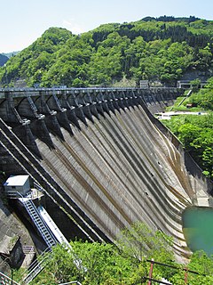
Miboro Dam is a dam on the Shō River in Shirakawa, in Gifu Prefecture Japan. It supports a 256 MW hydroelectric power station. Of the nine dams on the Shō River, it is the furthest upstream.

Sakaigawa Dam is a dam in Nanto, Toyama Prefecture and Shirakawa, Gifu Prefecture, Japan. It is named for the Sakaigawa River, upon which it is built. The dam has an associated 27 MW hydroelectric power station about 2.9 km (1.8 mi) downstream. It was commissioned in June 1993.

Miyashita Dam is a gravity dam on the Tadami River 2 km (1 mi) upstream of Mishima in the Fukushima Prefecture of Japan. It was constructed between 1941 and 1946 for the purpose of hydroelectric power generation. It supplies a 94 MW power station with water.

The Torul Dam is a concrete-face rock-fill dam on the Harşit River located 10 km (6 mi) northwest of Torul in Gümüşhane Province, Turkey. The development was backed by the Turkish State Hydraulic Works. Construction on the dam began in 1998 and was completed in 2007. The dam's hydroelectric power plant was commissioned in 2008. Water is diverted through a tunnel and penstock on the river's north side where it reaches the power plant located about 4 km (2 mi) downstream. It has an installed capacity of 121.5 MW.

The Wadagawa Dam is a gravity dam on the Wadagawa River in Tonami, Toyama Prefecture, Japan. It was constructed between 1962 and 1967. The dam has an associated 7.4 MW hydroelectric power station which was commissioned in 1968. Of the dams in the Shō River system, it is the furthest downstream.

The Shogawa Goguchi Dam is a gravity dam on the Shō River in Shogawa, Toyama Prefecture, Japan. It was constructed between 1934 and 1939. The dam has an associated 23.4 MW hydroelectric power station which was commissioned in two stages, December 1939 and March 1967. Of the nine dams on the Shō River it is the furthest downstream.

The Togagawa Dam is a gravity dam on the Togagawa River near Taikanba village about 26 km (16 mi) southeast of Shogawa in Toyama Prefecture, Japan. It was completed in June 1974. The dam has an associated 16.1 MW hydroelectric power station 5.8 km (3.6 mi) downstream near the Senzoku Dam reservoir. It was commissioned in December 1973.

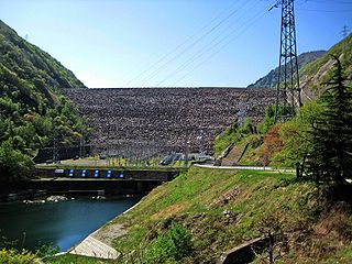
The Soyama Dam is a gravity dam on the Shō River in Soyama village about 13 km (8.1 mi) southeast of Nanto in Toyama Prefecture, Japan. It was constructed between 1927 and 1930. The dam has an associated 128.1 MW hydroelectric power station which was built in two parts. The first part of the power station was commissioned in 1930 and the second part of the power station was commissioned in 1967. Of the nine dams on the Shō River it is the third furthest downstream.

The Ohara Dam is a gravity dam on the Shō River in Ohara village about 17 km (11 mi) south of Nanto in Toyama Prefecture, Japan. It was constructed between 1939 and 1942. The dam has an associated 97.6 MW hydroelectric power station which was built in two parts. The first part of the power station was commissioned in 1942 and the second part of the power station was commissioned in 1980. Of the nine dams on the Shō River it is the fourth furthest downstream.

The Akao Dam is a gravity dam on the Shō River in Nishiakao village about 18 km (11 mi) south of Nanto in Toyama Prefecture, Japan. It was constructed between 1974 and 1978. The dam has an associated 34 MW hydroelectric power station which was commissioned in 1978. Of the nine dams on the Shō River it is the fifth furthest downstream.

The Narude Dam is a gravity dam on the Shō River about 22 km (14 mi) south of Nanto on the border of Toyama and Gifu Prefectures, Japan. It was constructed between 1950 and 1952. The dam has an associated 97 MW hydroelectric power station which was built in two parts. The first part of the power station was commissioned in 1951 and the second part of the power station was commissioned in 1975. Of the nine dams on the Shō River it is the sixth furthest downstream.

The Tsubawara Dam, also known as the Tsubakihara Dam, is a gravity dam on the Shō River about 5 km (3.1 mi) north of Shirakawa in Gifu Prefecture, Japan. It was constructed between 1952 and 1953. The dam has an associated 107 MW hydroelectric power station which was built in two parts. The first part of the power station was commissioned in 1954 and the second part of the power station was commissioned in 1975. Of the nine dams on the Shō River it is the seventh furthest downstream.

The Hatogaya Dam is a gravity dam on the Shō River about 2 km (1.2 mi) south of Shirakawa in Gifu Prefecture, Japan. It was constructed between 1954 and 1956. The dam has an associated 43 MW hydroelectric power station which was commissioned in 1956. Of the nine dams on the Shō River it is the eighth furthest downstream.

The Oshirakawa Dam is a rock-fill dam on the Oshirakawa River about 16 km (9.9 mi) southwest of Shirakawa in Gifu Prefecture, Japan. It was constructed between 1961 and 1963. The dam has an associated 66.3 MW hydroelectric power station located about 7.1 km (4.4 mi) downstream which was commissioned in 1963.
The Okurodani Dam is a rock-fill dam on the Oshirakawa River about 7 km (4.3 mi) west of Shōkawa in Gifu Prefecture, Japan. It was constructed between 1969 and 1971. The dam has an associated 21.2 MW hydroelectric power station located about 3.5 km (2.2 mi) downstream which was commissioned in 1971.

The Kukule Ganga Dam is a 110 m (360 ft) gravity dam built across the Kukule River in the Sabaragamuwa Province of Sri Lanka. The run-of-river-type dam feeds an underground hydroelectric power station located approximately 5 kilometres (3.1 mi) away, via tunnel.

The Shimokotori Dam is a rock-fill dam on the Shimokotori River about 15 km (9.3 mi) west of Hida in Gifu Prefecture, Japan. The primary purpose of the dam is hydroelectric power generation and water from its reservoir is diverted via a 8.5 km (5.3 mi) long headrace tunnel to a 142 MW power station northeast of the dam. The power station discharges the water into the Jinzū River. Construction on the dam began in 1970 and it was completed in 1973. The power station went operational in May 1973 and is owned by Kansai Electric Power Company.