
Gökçekaya Dam is 43 km (27 mi) north of Alpu town 45 km (28 mi) east of province of Eskişehir in central Turkey and located 60 km (37 mi) downstream of Sarıyar Dam on the Sakarya River which runs into the Black Sea. The Yenice Dam is located downstream.

The Ranapratap Sagar Dam is a gravity masonry dam of 53.8 metres (177 ft) height built on the Chambal River at Rawatbhata in Rajasthan in India. It is part of integrated scheme of a cascade development of the river involving four projects starting with the Gandhi Sagar Dam in the upstream reach in Madhya Pradesh and the Jawahar Sagar Dam on the downstream with a terminal structure of the Kota Barrage in Rajasthan for irrigation.

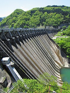
Sakaigawa Dam is a dam in Nanto, Toyama Prefecture and Shirakawa, Gifu Prefecture, Japan. It is named for the Sakaigawa River, upon which it is built. The dam has an associated 27 MW hydroelectric power station about 2.9 km (1.8 mi) downstream. It was commissioned in June 1993.

Yanaizu Dam is a gravity dam on the Tadami River 2 km (1 mi) upstream of Yanaizu in the Fukushima Prefecture of Japan. It was constructed between December 1952 and August 1953 for the purpose of hydroelectric power generation. It supplies a 75 MW power station with water.

Miyashita Dam is a gravity dam on the Tadami River 2 km (1 mi) upstream of Mishima in the Fukushima Prefecture of Japan. It was constructed between 1941 and 1946 for the purpose of hydroelectric power generation. It supplies a 94 MW power station with water.
Kığı Dam is a rock-fill embankment dam on the Peri River in Bingöl Province, Turkey. Its primary purpose is hydroelectric power generation and is the first dam in the Peri River cascade, serving as the headwaters. Construction began in 1998 and is backed by the Turkish State Hydraulic Works. When commissioned, it will support a 180 MW power station. Water from the reservoir will be diverted to an underground power station downstream via an 8.5 km (5.3 mi) long tunnel. In August 2015, suspected Kurdistan Workers' Party militants set fire to three cement trucks associated with the dam construction site. In January 2016, the dam was completed and the reservoir began to impound water.

The Upper Kotmale Dam is located in Talawakele, within the Nuwara Eliya District, in the Central Province of Sri Lanka. The dam feeds the third largest hydroelectric power station in the country.

The Okutadami Dam (奥只見ダム) is a concrete gravity dam on the Tadami River, 26 km (16 mi) east of Uonuma on the border of Niigata and Fukushima Prefectures, Japan. The primary purpose of the dam is hydroelectric power generation and it supports a 560 MW power station which is the largest conventional hydroelectric power station in Japan. The dam also forms the second largest reservoir in Japan, next to that of the Tokuyama Dam.
The Komaki Dam is an arch-gravity dam on the Shō River about 2.5 km (1.6 mi) southeast of Shogawa in Toyama Prefecture, Japan. It was constructed between 1925 and 1930. The dam has an associated 90.2 MW hydroelectric power station which was commissioned in 1930. Of the nine dams on the Shō River it is the second-furthest downstream.

The Toga Dam is a gravity dam on the Togagawa River near Omaki village about 11 km (6.8 mi) southeast of Shogawa in Toyama Prefecture, Japan. It was constructed between 1941 and 1943. The dam diverts water to the 17.6 MW Omaki hydroelectric power station 4.3 km (2.7 mi) to the west on the Shō River. It was commissioned in 1944.

The Senzoku Dam is a gravity dam on the Togagawa River about 20 km (12 mi) south of Shogawa in Toyama Prefecture, Japan. It was completed in 1974. The dam sends water to the 32.7 MW Togagawa II hydroelectric power station 5.7 km (3.5 mi) to the west on the Shō River. It was commissioned in 1973.

The Soyama Dam is a gravity dam on the Shō River in Soyama village about 13 km (8.1 mi) southeast of Nanto in Toyama Prefecture, Japan. It was constructed between 1927 and 1930. The dam has an associated 128.1 MW hydroelectric power station which was built in two parts. The first part of the power station was commissioned in 1930 and the second part of the power station was commissioned in 1967. Of the nine dams on the Shō River it is the third furthest downstream.

The Ohara Dam is a gravity dam on the Shō River in Ohara village about 17 km (11 mi) south of Nanto in Toyama Prefecture, Japan. It was constructed between 1939 and 1942. The dam has an associated 97.6 MW hydroelectric power station which was built in two parts. The first part of the power station was commissioned in 1942 and the second part of the power station was commissioned in 1980. Of the nine dams on the Shō River it is the fourth furthest downstream.

The Akao Dam is a gravity dam on the Shō River in Nishiakao village about 18 km (11 mi) south of Nanto in Toyama Prefecture, Japan. It was constructed between 1974 and 1978. The dam has an associated 34 MW hydroelectric power station which was commissioned in 1978. Of the nine dams on the Shō River it is the fifth furthest downstream.

The Narude Dam is a gravity dam on the Shō River about 22 km (14 mi) south of Nanto on the border of Toyama and Gifu Prefectures, Japan. It was constructed between 1950 and 1952. The dam has an associated 97 MW hydroelectric power station which was built in two parts. The first part of the power station was commissioned in 1951 and the second part of the power station was commissioned in 1975. Of the nine dams on the Shō River it is the sixth furthest downstream.

The Tsubawara Dam, also known as the Tsubakihara Dam, is a gravity dam on the Shō River about 5 km (3.1 mi) north of Shirakawa in Gifu Prefecture, Japan. It was constructed between 1952 and 1953. The dam has an associated 107 MW hydroelectric power station which was built in two parts. The first part of the power station was commissioned in 1954 and the second part of the power station was commissioned in 1975. Of the nine dams on the Shō River it is the seventh furthest downstream.

The Hatogaya Dam is a gravity dam on the Shō River about 2 km (1.2 mi) south of Shirakawa in Gifu Prefecture, Japan. It was constructed between 1954 and 1956. The dam has an associated 43 MW hydroelectric power station which was commissioned in 1956. Of the nine dams on the Shō River it is the eighth furthest downstream.

The Oshirakawa Dam is a rock-fill dam on the Oshirakawa River about 16 km (9.9 mi) southwest of Shirakawa in Gifu Prefecture, Japan. It was constructed between 1961 and 1963. The dam has an associated 66.3 MW hydroelectric power station located about 7.1 km (4.4 mi) downstream which was commissioned in 1963.
The Okurodani Dam is a rock-fill dam on the Oshirakawa River about 7 km (4.3 mi) west of Shōkawa in Gifu Prefecture, Japan. It was constructed between 1969 and 1971. The dam has an associated 21.2 MW hydroelectric power station located about 3.5 km (2.2 mi) downstream which was commissioned in 1971.


