Related Research Articles

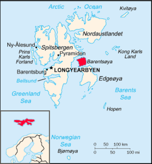
Svalbard ( SVAHL-bar, Urban East Norwegian: [ˈsvɑ̂ːɫbɑr]; previously known as Spitsbergen, or Spitzbergen, is a Norwegian archipelago in the Arctic Ocean. Situated north of mainland Europe, it is about midway between the northern coast of Norway and the North Pole. The islands of the group range from 74° to 81° north latitude, and from 10° to 35° east longitude. The largest island is Spitsbergen, followed by Nordaustlandet and Edgeøya, and the largest settlement is Longyearbyen.

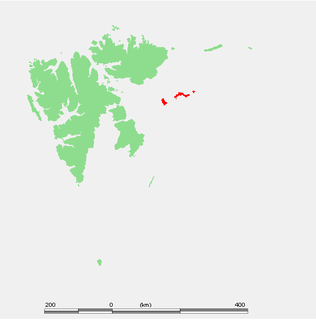
Svalbard is an archipelago in the Arctic Ocean roughly centered on 78° north latitude and 20° east longitude. The archipelago is the northernmost part of the Kingdom of Norway. The three main islands in the group consist of Spitsbergen, Nordaustlandet and Edgeøya. There are also a number of smaller islands, such as Barents Island (Barentsøya), Kvitøya, Prins Karls Forland, Kongsøya, Bear Island, Svenskøya, Wilhelm Island and other smaller islands or skerries.

Norway is a country located in Northern Europe on the northern and western parts of the Scandinavian Peninsula. The majority of the country borders water, including the Skagerrak inlet to the south, the North Sea to the southwest, the North Atlantic Ocean to the west, and the Barents Sea to the north. It has a land border with Sweden to the east and a shorter border with Finland and an even shorter border with Russia to the northeast.
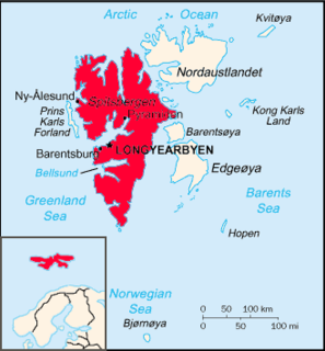
Spitsbergen is the largest and only permanently populated island of the Svalbard archipelago in northern Norway. Constituting the westernmost bulk of the archipelago, it borders the Arctic Ocean, the Norwegian Sea, and the Greenland Sea. Spitsbergen covers an area of 37,673 km2 (14,546 sq mi), making it the largest island in Norway and the 36th-largest in the world. The administrative centre is Longyearbyen. Other settlements, in addition to research outposts, are the Russian mining community of Barentsburg, the research community of Ny-Ålesund, and the mining outpost of Sveagruva. Spitsbergen was covered in 21,977 km2 (8,485 sq mi) of ice in 1999, which was approximately 58.5% of the island's total area.

Svalbard and Jan Mayen is a statistical designation defined by ISO 3166-1 for a collective grouping of two remote jurisdictions of Norway: Svalbard and Jan Mayen. While the two are combined for the purposes of the International Organization for Standardization (ISO) category, they are not administratively related. This has further resulted in the country code top-level domain .sj being issued for Svalbard and Jan Mayen, and ISO 3166-2:SJ. The United Nations Statistics Division also uses this code, but has named it Svalbard and Jan Mayen Islands.

Longyearbyen is the largest settlement and the administrative centre of Svalbard, Norway. It stretches along the foot of the left bank of the Longyear Valley and on the shore of Adventfjorden, the short estuary leading into Isfjorden on the west coast of Spitsbergen, the island's broadest inlet. Since 2002 Longyearbyen Community Council has had many of the same responsibilities as a Norwegian municipality, including utilities, education, cultural facilities, fire brigade, roads and ports. The town is the seat of the Governor of Svalbard. It is the world's northernmost settlement of any kind with more than 1,000 permanent residents. Since 2015 Arild Olsen has served as Mayor.

Nordaustlandet is the second-largest island in the archipelago of Svalbard, Norway, with an area of 14,443 square kilometres (5,576 sq mi). It lies north east of Spitsbergen, separated by Hinlopen Strait. Much of Nordaustlandet lies under large ice caps, mainly Austfonna and Vestfonna, the remaining parts of the north being tundra inhabited by reindeer and walruses. The island is uninhabited and lies entirely within Nordaust-Svalbard Nature Reserve.

The extreme points of Norway include the coordinates that are farther north, south, east or west than any other location in Norway; and the highest and the lowest altitudes in the country. The northernmost point is Rossøya on Svalbard, the southernmost is Pysen in Mandal, the easternmost is Kræmerpynten on Svalbard, and the westernmost is Hoybergodden on Jan Mayen. The highest peak is Galdhøpiggen, standing at 2,469 m (8,100 ft) above mean sea level, while the lowest elevation is sea level at the coast.

The Svalbard Treaty recognises the sovereignty of Norway over the Arctic archipelago of Svalbard, at the time called Spitsbergen. The exercise of sovereignty is, however, subject to certain stipulations, and not all Norwegian law applies. The treaty regulates the demilitarisation of the archipelago. The signatories were given equal rights to engage in commercial activities on the islands. As of 2012, Norway and Russia are making use of this right.

The Norwegian Polar Institute is Norway's central governmental institution for scientific research, mapping and environmental monitoring in the Arctic and the Antarctic. The NPI is a directorate under Norway's Ministry of Climate and Environment. The institute advises Norwegian authorities on matters concerning polar environmental management and is the official environmental management body for Norwegian activities in Antarctica.
Barentsøya, sometimes anglicized as Barents Island, is an island in the Svalbard archipelago of Norway, lying between Edgeøya and Spitsbergen. Barents Island has no permanent human inhabitants. Named for the Dutch explorer Willem Barents, it is a part of Søraust-Svalbard Nature Reserve.

The Svalbard Global Seed Vault is a secure seed bank on the Norwegian island of Spitsbergen in the remote Arctic Svalbard archipelago. Conservationist Cary Fowler, in association with the Consultative Group on International Agricultural Research (CGIAR), started the vault to preserve a wide variety of plant seeds that are duplicate samples, or "spare" copies, of seeds held in gene banks worldwide. The seed vault is an attempt to ensure against the loss of seeds in other genebanks during large-scale regional or global crises. The seed vault is managed under terms spelled out in a tripartite agreement among the Norwegian government, the Crop Trust, and the Nordic Genetic Resource Center (NordGen).

Svalbard Airport, Longyear is the main airport serving Svalbard in Norway. It is 5 km (3.1 mi) northwest of Longyearbyen on the west coast, and is the northernmost airport in the world with scheduled public flights. The first airport near Longyearbyen was constructed during World War II. In 1959, it was first used for occasional flights, but could only be used a few months a year. Construction of the new airport at Hotellneset started in 1973, and the airport was opened on 2 September 1975. It is owned and operated by state-owned Avinor.
Kongsøya is an island in Svalbard, Norway. It is the largest of the islands in King Charles Land. Its area is 191 square kilometres (74 sq mi). The other main island in the chain is Svenskøya.
Indre Wijdefjorden National Park is located in a steep fjord landscape in northern Spitsbergen in Svalbard, Norway. It covers the inner part of Wijdefjorden—the longest fjord on Svalbard. The national park was established on 9 September 2005 and covers 1,127 km2 (435 sq mi), of which 745 km2 (288 sq mi) is on land and 382 km2 (147 sq mi) is sea. The marine environment changes vastly from the mouth of the fjord, through a still, cold, water basin, becoming deeper before reaching the glacier Mittag-Lefflerbreen at the inner-most sections of the fjord.
Novelists, screenwriters and filmmakers have set their works in Svalbard, an archipelago in the Arctic, the northernmost part of Norway yet closer to Greenland. Such works often make use of its Arctic climate, polar bears, isolation and the natural beauty of its dominant glaciers, mountains and fjords.

Oscar II Land is the land area between Isfjorden and Kongsfjorden on Spitsbergen, Svalbard. The 30 km (19 mi) long glacier Sveabreen divides Oscar II Land from James I Land.
Haakon VII Land is a land area at the northwestern part of Spitsbergen, Svalbard, between Woodfjorden and Kongsfjorden.
Nathorst Land is the land area between Van Keulenfjorden and Van Mijenfjorden on Spitsbergen, Svalbard.
Uniquely, the Norwegian archipelago of Svalbard, located in the High Arctic, is an entirely visa-free zone. However, travelers who have a visa requirement to enter mainland Norway/the Schengen area must have a visa if they travel via mainland Norway/the Schengen Area. This must be a double-entry visa so they can return to mainland Norway/the Schengen area. Those traveling to and from Svalbard must bring a passports or national ID-card, as identity control is performed for all. Passports or national identity cards satisfies the Schengen regulatory requirements for identity verification. Due to a transitional arrangement, Norwegian citizens can also prove their identity with a document issued in Norway which includes at least name, photo and date of birth, such as a Norwegian driving licence issued after 1998. The transitional period ends on 31 December 2021.
References
- ↑ "Wahlenbergfjellet (Svalbard)". Norwegian Polar Institute . Retrieved 12 June 2014.
- ↑ Lauritzen, Per Roger, ed. (2009). "Wahlenbergfjellet". Norsk Fjelleksikon (in Norwegian). Arendal: Friluftsforlaget. ISBN 978-82-91-49547-7.
| This Spitsbergen mountain, mountain range, or peak related article is a stub. You can help Wikipedia by expanding it. |