Related Research Articles

The Taupō Volcanic Zone (TVZ) is a volcanic area in the North Island of New Zealand that has been active for the past two million years and is still highly active. Mount Ruapehu marks its south-western end and the zone runs north-eastward through the Taupo and Rotorua areas and offshore into the Bay of Plenty. It is part of the larger Central Volcanic Region that extends further westward through the western Bay of Plenty to the eastern side of the Coromandel Peninsula and has been active for four million years. The Taupo Volcanic Zone is widening east–west at the rate of about 8 mm per year. It is named after Lake Taupo, the flooded caldera of the largest volcano in the zone, the Taupo Volcano.
The Ahuroa River is a river in the Northland Region of the North Island of New Zealand.
The North River is both a stream and a small settlement on that stream, in Northland Region. The stream flows through limestone caves before entering the Pohuenui River, which in turn flows into the Waipu River before this emerges into Bream Bay near Waipu.
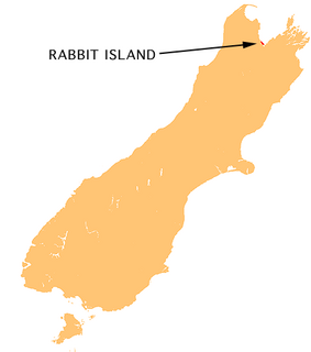
Moturoa / Rabbit Island is a small island that lies across the southernmost part of Tasman Bay / Te Tai-o-Aorere, on the northern coast of New Zealand's South Island. The long narrow island runs east–west for 8 kilometres (5 mi), and covers 15 km2 (5.8 sq mi).
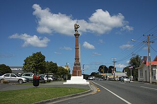
Waipu is a small town established in the rohe of the Patuharakeke hapū, in Te Tai Tokerauthe Northland Region of New Zealand. The town is celebrated for its settlement by Nova Scotians and other settlers of Scottish heritage. A highlight of the town's calendar is the annual Highland Games held at New Year. Near the town are the Waipu Caves, which contain a significant population of glow worms.

The Orongorongo River runs for 32 kilometres (20 mi) southwest through the Orongorongo Valley in the southern Remutaka Ranges of the North Island of New Zealand. The river and its associated catchments lie within the bounds of the Remutaka Forest Park, which is administered by the Department of Conservation.
The Waipu River is a river in the Northland Region of the North Island of New Zealand. It runs close to the town of Waipu. The river is popular with birdwatchers as species such as the New Zealand dotterel, oystercatchers and fairy terns live near it.

Whangarei District is a territorial authority district in the Northland Region of New Zealand that is governed by the Whangarei District Council. The district is made up in area largely by rural land, and includes a fifth of the Northland Region. It extends southwards to the southern end of Bream Bay, northwards to Whangaruru and almost to the Bay of Islands, and westwards up the Mangakahia River valley past Pakotai and almost to Waipoua Forest. It includes the Hen and Chicken Islands and the Poor Knights Islands.
The Kekerengu River is a river of New Zealand's northeastern South Island. It flows mainly through the area of rough hill country immediately to the north of the end of the Seaward Kaikoura Range, reaching the Pacific Ocean at Kekerengu, a small settlement halfway between the township of Ward and the mouth of the Clarence River.
The Omaumau River is a middle order stream in the Auckland Region of New Zealand's North Island. It flows northwest to reach the Kaipara Harbour 20 kilometres (12 mi) northeast of Helensville. The catchment consists of rural pasture and fragmented native forest.
The Papakanui River is a river of the Auckland Region of New Zealand's North Island. This short wide river forms part of the lower Kaipara Harbour system, adding its waters to the harbour close to the settlement of Tauhoa.
The Pohuenui River is a river of the Northland Region of New Zealand's North Island. It flows southeast, reaching the Waipu River close to the latter's mouth, immediately north of the town of Waipu.
The Waitoetoe River is a small river of the Taranaki Region of New Zealand's North Island. It flows close to the town of Urenui.
The Wharehine River is a river in New Zealand. Located west of Wellsford, it is a tributary of the Oruawharo River.

The Whitcombe River is a river of the West Coast Region of New Zealand's South Island. It flows north to reach the Hokitika River 30 kilometres south of Hokitika.

Bream Bay is a locality and bay on the east coast of New Zealand. Captain James Cook named this area to include the bay itself, but also some surrounding locations, stretching north to Whangārei and south to Mangawhai. However, 'Bream Bay' is loosely used as a collaboration of the three major towns that satellite the main metropolitan area which are Ruakākā, One Tree Point and Waipu. The physical bay itself geographically spreads from the mouth of Whangārei Harbour, 22 kilometers south, to the southernmost point of Waipu Cove. The area also inhabits 3 native reserve islands, located just off the coast of Bream Bay: the Hen and Chicken Islands and Sail Rock Island.
The Waipu Lagoons is a series of small coastal lagoons near the city of New Plymouth in the Taranaki Region of New Zealand. They consist of three lakelets with a combined surface area of about 2 hectares, located 0.5 kilometres (0.31 mi) from the Tasman Sea, immediately to the east of Bell Block. The lagoons plus surrounding wetlands totalling 7.9 hectares are a local purpose conservation reserve owned by the New Plymouth District Council.

State Highway 12 is a New Zealand state highway in the far north of the North Island. It connects with SH 1 at both its northern and southern end. It runs close to the west coast of the Northland Region of New Zealand.
Waipu may refer to:
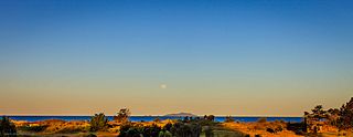
Uretiti Beach is a stretch of beach between Ruakākā and Waipu on Bream Bay to the south of Whangarei in Northland, New Zealand. It comprises the coastal side of the Uretiti Recreation Reserve and Uretiti Scenic Reserve, and is served by a Department of Conservation (DOC) campground within the Recreation Reserve. Uretiti Beach is popular for swimming, surfing, and fishing, and a well-known clothing-optional beach and gay cruising site.
References
"Place name detail: Waihoihoi River". New Zealand Gazetteer. New Zealand Geographic Board . Retrieved 12 July 2009.
Coordinates: 36°01′S174°25′E / 36.017°S 174.417°E