This article's factual accuracy may be compromised due to out-of-date information. Please help update this article to reflect recent events or newly available information.(May 2012)
Waikohu County was constituted in October, 1908. About two-thirds of the 2,300-square-kilometre (900sqmi) area was then in productive use. Much of the remainder was in heavy bush. Practically all the roads — 303 kilometres (188mi) — were unmetalled, many of them being only 2.7-metre (9ft) tracks. The council first met on 3 March 1909, its personnel being: W. D. S. MacDonald, A. M. Lewis, H. E. Tiffen, M. Campbell, H. Telford and E. M. Hutchinson. Mr. MacDonald was elected chairman.
The county took over a loan of NZ£4,941 from the Waikohu Road Board, also loans amounting to £25,907 from Cook County. It had, up to 31 March 1947, raised loans amounting, in the aggregate, to £88,815, all the money being borrowed in New Zealand. Debentures amounting to £42,000 were converted in 1935, and the conversion loan will expire in 1960. The net public debt at 31 March 1947, was £49,894. Approximately one-half will be paid off by 1950. Of the loans raised by the county, £8,500 was for bridges, £9,500 for homes for county employees, £6,600 towards the cost of building Cook Hospital (1914), and £63,455 for the construction of, and the metalling of, roads.
By 1947, 3.6 kilometres (2+1⁄4mi) of roads had been sealed, 478.8 kilometres (297+1⁄2mi) metalled, and 163 kilometres (101mi) formed to a width of 4.9 metres (16ft), but not metalled. The bridges then numbered 66, with an aggregate length of 2,104 metres (6,903ft). Te Karaka (the headquarters) was constituted a town district in 1916. Its board controls sanitation, a library, the side roads and footpaths. The main road is a State highway.
Statistics.—Rates: 1909–10, £7,813; 1946–7, £29,572. Ratepayers: 1909–10, 335; 1946–7, 623. Rateable properties: 1909–10, 637; 1946–47, 1,239. Capital value of the county: 1909–10, £1,407,172; 1949, £3,829,879.
Chairmen: W. D. S. MacDonald, 1909–11; E. M. Hutchinson, 1911–14; Cyril White, 1914–17; L. B. Tulloch, 1917–20; T. B. Spence, 1920–29; A. A. Fraser, 1929–. G. Warren was clerk from 1908 until 1915; J. G. Appleton (1915–49); then N. W. McCormick. Engineers: W. S. Charlesworth, 1909–10; J. Mouat, 1910–14; F. C. Hay, 1915–16; W. Whittaker, 1916–17; A. H. Benham, 1917–22; A. G. M. Lucas, 1922–45; S. R. Currie, 1945–.
There were 96 Europeans in the Waikohu Road District in 1878. The number of Maoris then is not officially known. In 1906, the combined population was 1858. By 1926, the European population was: County, 2,604; Te Karaka T.D., 321; Maoris, 488 and 48 respectively; grand total, 3,461. In 1945 the figures were: Europeans—County, 1,912; Te Karaka T.D., 262; Maoris—County, 919; Te Karaka T.D., 109; grand total, 3,202, plus 3 per cent. to make up for residents absent on war activities.
Te Karaka township site was covered with scrub and surrounded by heavy bush in the early 1880s. Its first white resident was George Burgess, a “bullocky.” A shepherd named McKinnon then built an hotel, the Isle of Mull, in thick bush near the river. In 1883, Mr. Hutton erected a sawmill at the back of the site on which the school now stands. A saddler's shop and a store followed. The sawmill was taken over by W. King in 1884. His manager (Alfred H. Salmon) and his wife were the first European married residents. A school, with only five pupils, was opened by C. E. Bolton in 1886. William Hunter was the first mailman.
Related Research Articles
Gisborne is a city in northeastern New Zealand and the largest settlement in the Gisborne District. It has a population of 37,700. The district council has its headquarters in Whataupoko, in the central city.
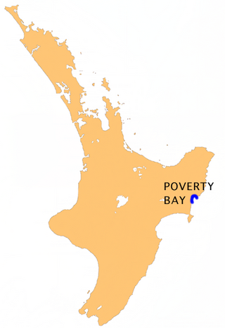
Poverty Bay is the largest of several small bays on the east coast of New Zealand's North Island to the north of Hawke Bay. It stretches for 10 kilometres (6 mi) from Young Nick's Head in the southwest to Tuaheni Point in the northeast. The city of Gisborne is located on the northern shore of the bay and the small settlement of Muriwai is located at the bay's southern end. The name is often used by extension to refer to the entire area surrounding the city of Gisborne. Poverty Bay is the home of the Māori iwi (tribes) Te Aitanga-a-Māhaki, Rongowhakaata and Ngāi Tāmanuhiri.
Mount Hikurangi is a 1,752 m (5,748 ft) peak in the eastern corner of New Zealand's North Island, about 80 kilometres (50 mi) north of Gisborne, and 50 kilometres (31 mi) southwest of the East Cape Lighthouse. On a spur of the Raukumara Range in the Waiapu Valley, it is the North Island's highest non-volcanic peak.
William Donald Stuart MacDonald was a New Zealand politician, Cabinet Minister, and briefly Leader of the Opposition.
Lake Mahinapua is a shallow lake on the West Coast of New Zealand's South Island. Once a lagoon at the mouth of the Hokitika River, it became a lake when the river shifted its course. Lake Māhinapua was the site of a significant battle between Ngāi Tahu and Ngāti Wairangi Māori, and is regarded by them as a sacred site where swimming and fishing are prohibited. In European times it was part of an inland waterway that carried timber and settlers between Hokitika and Ross until the building of the railway. Today it is protected as a scenic reserve for boating, camping, and hiking.
Gisborne District or the Gisborne Region is a local government area of northeastern New Zealand. It is governed by Gisborne District Council, a unitary authority. It is named after its largest settlement, the city of Gisborne. The region is also commonly referred to as the East Coast.
Wiremu "Wi" Pere, was a Māori Member of Parliament in New Zealand. He represented Eastern Māori in the House of Representatives from 1884 to 1887, and again from 1893 to 1905. Pere's strong criticism of the government's Māori land policies and his involvement in the turbulent land wars in the 1860s and 1870s made him a revered Māori leader and he was known throughout his career as an contentious debator and outstanding orator in the use of the Māori language.
The Waipaoa River is a river of the northeast of New Zealand's North Island. It rises on the eastern slopes of the Raukumara Range, flowing south for 80 kilometres (50 mi) to reach Poverty Bay and the Pacific Ocean just south of Gisborne. For about half of this distance its valley is followed by State Highway 2. The river has several important tributaries, among them the Wharekopai, Waikohu, Mangatu, Waingaromia and Waihora rivers. Major settlements along the banks of the river include Te Karaka, Ormond, and Patutahi.
The Wharekōpae River is located in the northeast of New Zealand's North Island. A tributary of the Waikohu River, it rises on the slopes of Maungatapere, a 1,050-metre (3,440 ft) peak at the northeastern end of the Huiarau Range, and flows east, reaching the Waikohu River at the settlement of Waikohu, west of Te Karaka.
Ruapani was a rangatira (chief) of the Māori in Tūranganui-a-Kiwa in the 15th and 16th century.
The Waihuka River is a river of the Gisborne Region of New Zealand's North Island. It flows generally east to reach the Waikohu River 10 kilometres (6 mi) west of Te Karaka. State Highway 2 follows the course of the Waihuka for part of its route between Te Karaka and Matawai.
Cook County was one of the counties of New Zealand in the North Island. It was established in 1876 and comprised the areas which today form the counties of Cook, Waikohu, Uawa, Waiapu and Matakaoa County, extending from Cape Runaway in the north to Paritu in the south. It was disestablished in 1989.
Gisborne District Council is the unitary authority for the Gisborne District of New Zealand. The council consists of a mayor and 13 ward councillors. The district consists of the city of Gisborne and a largely rural region on the east coast of the North Island.
Te Kani-a-Takirau was a notable New Zealand tribal leader. Of Māori descent, he identified with Hapu Matua of the Te Aitanga A Hauiti Iwi. He was born in on the East Coast of New Zealand. He is well known for having refused to sign the Treaty of Waitangi in 1840.
Iharaira Te Houkamau (?–1875) was a notable New Zealand tribal leader. Of Māori descent, he identified with the Ngati Porou iwi.
Waipiro Bay is a small coastal settlement in the Gisborne District on the East Coast of the North Island of New Zealand. The name also refers to the bay that the settlement is built on. It was named Waipiro by Chief Paoa, which translates literally to "putrid water", referring to the area's sulphuric properties. It is in the Waiapu ward, along with nearby towns Te Puia Springs, Tokomaru Bay, and Ruatoria. It is located 15 km (9 mi) south of Ruatoria, 77 km (48 mi) north-east of Gisborne, and 41 km (25 mi) south-west of the East Cape Lighthouse, the easternmost point of mainland New Zealand. By road, it is 103 km (64 mi) from Gisborne, and 231 km (144 mi) from Ōpōtiki. Waipiro Bay is governed by the Gisborne District Council, and is in the East Coast electorate.
Waiapu Valley, also known as the Waiapu catchment, Waiapu River valley or simply Waiapu, is a valley in the north of the Gisborne Region on the East Coast of the North Island of New Zealand. It is the catchment area for the Waiapu River and its tributaries, and covers 1,734 square kilometres (670 sq mi). The Raukumara Range forms the western side of the valley, with Mount Hikurangi in the central west. The towns of Ruatoria and Tikitiki are in the north-east of the valley.
Waiapu County was one of the counties of New Zealand on the North Island.
Matakaoa County was one of the counties of New Zealand in the North Island.
Akuaku, also known as Aku Aku, was a settlement approximately halfway between Waipiro Bay and Whareponga in the East Coast region of New Zealand's North Island. A traditional landing point for waka taua, the town is most notable now as the former home of Major Ropata Wahawaha, N.Z.C, as well as the ancestral home of Te Whānau-a-Rākairoa.
This page is based on this Wikipedia article Text is available under the CC BY-SA 4.0 license; additional terms may apply. Images, videos and audio are available under their respective licenses.