The national parks of New Zealand are protected natural areas administered by the Department of Conservation (DOC). The first national parks established in the country were all focused on mountain scenery. Since the 1980s the focus has been on developing a more diverse representation of New Zealand landscapes. The parks are all culturally significant and many also contain historic features. Tongariro National Park is one of the World Heritage Sites that are of both cultural and natural significance, while four of the South Island national parks form Te Wahipounamu, another World Heritage Site. There are currently 13 national parks; a 14th, Te Urewera National Park, was disestablished in 2014.

Agathis australis, commonly known by its Māori name kauri, is a coniferous tree in the family Araucariaceae, found north of 38°S in the northern regions of New Zealand's North Island.

The Northland Region is the northernmost of New Zealand's 16 local government regions. New Zealanders sometimes refer to it as the Winterless North because of its mild climate all throughout the year. The main population centre is the city of Whangārei, and the largest town is Kerikeri. At the 2018 New Zealand census, Northland recorded a population growth spurt of 18.1% since the previous 2013 census, placing it as the fastest growing region in New Zealand, ahead of other strong growth regions such as the Bay of Plenty Region and Waikato.

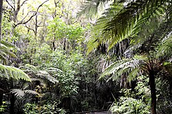
Waipoua Forest is a forest, on the west coast of the Northland Region of New Zealand's North Island. It preserves some of the best examples of kauri forest remaining in New Zealand. It is notable for having two of the largest living kauri trees, Tāne Mahuta and Te Matua Ngahere.

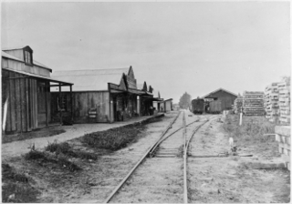
Dargaville is a town located in the North Island of New Zealand. It is situated on the bank of the Northern Wairoa River in the Kaipara District of the Northland region. The town is located 55 kilometres southwest of Whangārei. Dargaville is 174 kilometres north of Auckland.

Kaipara Harbour is a large enclosed harbour estuary complex on the north western side of the North Island of New Zealand. The northern part of the harbour is administered by the Kaipara District and the southern part is administered by the Auckland Council. The local Māori tribe is Ngāti Whātua.
Tāne Mahuta, also called "God of the Forest", is a giant kauri tree in the Waipoua Forest of Northland Region, New Zealand. Its age is unknown but is estimated to be between 1,250 and 2,500 years. It is the largest living kauri tree known to stand today. It is named for Tāne, the Māori god of forests and of birds.

Te Matua Ngahere is a giant kauri coniferous tree in the Waipoua Forest of Northland Region, New Zealand. The tree's Māori name means "Father of the Forest". Although not as massive or tall as its neighbour Tāne Mahuta, Te Matua Ngahere is stouter, with a girth just over 16 metres (52 ft). It is believed to be the second largest living kauri tree, and to have the biggest girth of any kauri in the country. According to The New Zealand Herald, it has the biggest girth of any tree in New Zealand.
Ngāti Mahuta is a sub-tribe of the Waikato tribe of Māori in the North Island of New Zealand. The territory (rohe) of Ngāti Mahuta is the Kawhia and Huntly areas of the Waikato region.
Mangamuka is a district in Northland, New Zealand, at the junction of the Mangamuka and Opurehu Rivers. State Highway 1 runs through the area, and the settlement of Mangamuka Bridge lies at the point where the highway crosses the Mangamuku River. The river runs into the upper Hokianga Harbour. Just to the north west, the highway runs through Mangamuka Gorge in the Maungataniwha Range. Umawera lies to the south east.
Aranga is a locality in Northland, New Zealand. State Highway 12 passes through it. Ōmāpere is 47 km northwest, and Dargaville is 42 km southeast. The Waipoua Forest is to the north. Maunganui Bluff and the Tasman Sea are to the west, with the small settlement of Aranga Beach lying at the northern end of Ripiro Beach.
Arapohue is a locality in Northland, New Zealand, approximately 16 km south east of Dargaville
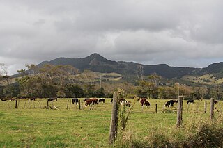
Kaihu is a locality and settlement in Northland, New Zealand. The Kaihu River runs through the Kaihu Valley into the Wairoa River near Dargaville, approximately 32 km south east. State Highway 12 runs along the valley and passes through Kaihu settlement. Aranga is about 10 km north west. The Kaihu Forest is to the east and the Marlborough Forest is to the north.

Te Roroa is a Māori iwi from the region between the Kaipara Harbour and the Hokianga Harbour in Northland, New Zealand. They are part of the Ngāti Whātua confederation of tribes.
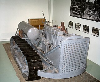
The Kauri Museum is in the west coast village of Matakohe, Northland, New Zealand. The museum, to the south of the Waipoua Forest, contains many exhibits that tell the story of the pioneering days when early European settlers in the area extracted kauri timber and kauri gum.
Waimamaku is a village and rural community, based along the banks of the Waimamaku River south of the Hokianga Harbour on the west coast of New Zealand's North Island. It is located in the Far North District and Northland Region on State Highway 12, south of Ōmāpere and north of Waipoua.
Takahiwai is a rural community west of Marsden Bay, in the Whangarei District and Northland Region of New Zealand's North Island.

Tākou Bay is a bay and rural community in the Far North District and Northland Region of New Zealand's North Island, beside the Tākou River. Tākou Bay is an official name, gazetted on 16 July 2020.
Northland Conservation Park is a group of protected areas in the Northland Region of New Zealand's North Island.
A sanctuary area is a type of New Zealand protected area. They exist to preserve populations of important forest types, like the remnants of kauri forests in Northland.