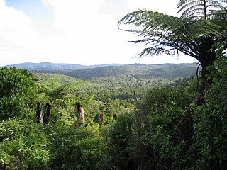
The Waitākere Ranges is a mountain range in New Zealand. Located in West Auckland between metropolitan Auckland and the Tasman Sea, the ranges and its foothills and coasts comprise some 27,720 hectares of public and private land. The area, traditionally known to Māori as Te Wao Nui o Tiriwa, is of local, regional, and national significance. The Waitākere Ranges includes a chain of hills in the Auckland Region, generally running approximately 25 kilometres (16 mi) from north to south, 25 km west of central Auckland. The ranges are part of the Waitākere Ranges Regional Park.

The Brecon Mountain Railway is a 1 ft 11+3⁄4 in narrow gauge tourist railway on the south side of the Brecon Beacons in Wales. It climbs northwards from Pant along the full length of the Pontsticill Reservoir and continues past the adjoining Pentwyn Reservoir to Torpantau railway station. The railway's starting point at Pant is located two miles (3 km) north of the town centre of Merthyr Tydfil, Merthyr Tydfil County Borough, South-East Wales.

The Clifton Rocks Railway was an underground funicular in Bristol, England, linking Clifton at the top to Hotwells and Bristol Harbour at the bottom of the Avon Gorge in a tunnel cut through the limestone cliffs.

Waitākere railway station is a disused station on the North Auckland Line located in the village of Waitākere, to the north-west of Auckland, New Zealand. It served as the western terminus of the Western Line of the Auckland suburban network until July 2015, when services were restricted to Swanson and Waitakere Station was closed.

Swanson railway station is a station on the North Auckland Line in Auckland, New Zealand.

Avondale railway station is on the Western Line of the Auckland railway network. Relocated in 2008, the station can be accessed from St Jude St, Layard St, and Crayford St.

The Upper Nepean Scheme is a series of dams and weirs in the catchments of the Cataract, Cordeaux, Avon and Nepean rivers of New South Wales, Australia. The scheme includes four dams and two weirs, and a gravity-fed canal system that feeds into a large storage reservoir to provide water to the Macarthur and Illawarra regions, the Wollondilly Shire, and metropolitan Sydney. The four dams and associated infrastructure are individually listed on the New South Wales State Heritage Register.

Beacons Reservoir is the northernmost of the three reservoirs in the Taff Fawr valley in South Wales. It was built by Cardiff Corporation Waterworks between 1893 and 1897, and the water is impounded by an earth dam with a clay core. Since 1973 it has been owned by Welsh Water. As its name suggests, it is located in the Brecon Beacons National Park in the Powys unitary authority area and within the historic county boundaries of Breconshire.

Cantref Reservoir is the middle of the three reservoirs in the Taff Fawr valley in Wales. It was built by Cardiff Corporation Waterworks between 1886 and 1892, but since 1973 has been owned by Welsh Water. It is located in the Brecon Beacons National Park, mostly in the Powys unitary authority area and within the historic county boundaries of Breconshire. Part of the south west corner is in the Rhondda Cynon Taff unitary authority area.

The former Victorian Railways, the state railway authority in Victoria, Australia, built a number of experimental 2 ft 6 in narrow-gauge lines around the beginning of the 20th century. Although all were closed by the early 1960s, parts of two have been reopened as heritage railways.

The Wee Georgie Wood Railway is a 2 ft narrow gauge tourist tramway running from Tullah, on a 1.9 km short track by the edge of Lake Rosebery in the West Coast Municipality of Tasmania.

The Lochaber Narrow Gauge Railway was a 3 ft narrow-gauge industrial railway. It was a relatively long line, built for the construction and subsequent maintenance of a 15-mile-long (24-kilometre) tunnel from Loch Treig to a factory near Fort William in Scotland. The tunnel was excavated to carry water for the Lochaber hydroelectric scheme in connection with aluminium production by British Aluminium. The railway came to be known colloquially as the 'Old Puggy Line'.

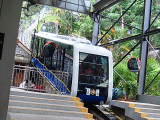
The Penang Hill Railway is a one-section funicular railway which climbs the Penang Hill from Air Itam, on the outskirts of the city of George Town in the Malaysian state of Penang. The railway first opened in 1923 as a two-section railway, but was overhauled in 2010 into a one-section system. It is a single-track railway with a passing loop, and it passes through a tunnel which is the steepest in the world. The total journey time can take between five and twenty minutes. The funicular train coach travels directly from the lower station to the top, but may stop at other intermediate stations upon request.

The Cowlyd Tramway was a 2 ft narrow gauge railway line used to convey men and materials to Llyn Cowlyd Reservoir, near Trefriw in northern Wales during the enlargement of the dam, and thereafter for maintenance purposes.

The Lower Nihotupu Reservoir is one of five reservoirs in the Waitākere Ranges that supply water to Auckland. Built between 1945 and 1948, the reservoir covers an area of 52.9 hectares and has a capacity of 4.6 million cubic metres. The reservoir is managed by Watercare Services, a council-owned company.

Waitākere Reservoir is a reservoir on the Waitakere River in the Waitākere Ranges, west of Auckland in New Zealand. The dam was completed in 1910 and is a concrete gravity dam with a slight curvature. It has a lake area of 25.1 hectares and a capacity of 1.76 million cubic metres. The dam is accessible from the Montana Heritage Trail, a bush hike in the region.

Nidd Valley Light Railway was a light railway in upper Nidderdale in the West Riding of Yorkshire, England. It was owned by Bradford Corporation Waterworks Department and the corporation also operated its public passenger services. Power & Traction Ltd of London obtained a Light Railway Order for the 6.5-mile (10.5 km) railway from Pateley Bridge to Lofthouse in 1900, but these powers were taken over by Bradford Corporation. A contract to build Angram Reservoir was awarded to John Best & Son in 1903, and he also won the contract to build the public railway and a 6.5-mile (10.5 km) private extension to the reservoir site. This was initially built to 3 ft gauge but was converted to standard gauge by 1907, when the public railway opened. Best had his own locomotives, and Bradford Corporation equipped the public railway with second hand locomotives and carriages from the Metropolitan Railway.

The Waitākere River is a river of the Auckland Region of New Zealand's North Island. It flows north then west from its sources in the Waitākere Ranges, reaching the Tasman Sea at Te Henga / Bethells Beach, to the south of Muriwai Beach. The upper reaches of the river are dammed to form the Waitākere Reservoir. The Waitākere Falls, just below the dam, are 95 metres (312 ft) high and the third highest waterfall in the North Island.

The Upper Nihotupu Reservoir is one of five reservoirs in the Waitākere Ranges that supply water to Auckland, New Zealand. Completed in 1923, the concrete gravity dam and its reservoir are managed by Watercare Services, a council-owned company.

The Nihotupu Tramline is a 6.5 kilometres (4.0 mi) long industrial narrow gauge railway at Nihotupu in the Waitākere Ranges south-west of Auckland in New Zealand, which since 1907 has been used for building and maintaining the dam and water pipeline at the Upper Nihotupu Reservoir. It was used until 24 November 2014 also by the Rainforest Express for tourist excursions, which have been indefinitely ceased due to a risk assessment.


