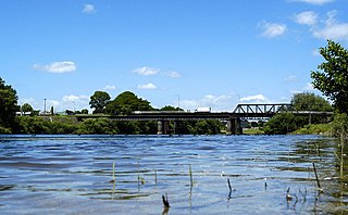
Ngāruawāhia is a town in the Waikato region of the North Island of New Zealand. It is located 20 kilometres (12 mi) north-west of Hamilton at the confluence of the Waikato and Waipā Rivers, adjacent to the Hakarimata Range. Ngāruawāhia is in the Hamilton Urban Area, the fourth largest urban area in New Zealand. The location was once considered as a potential capital of New Zealand.
Waipukurau is the largest town in the Central Hawke's Bay District on the east coast of the North Island of New Zealand. It is located on the banks of the Tukituki River, 7 kilometres south of Waipawa and 50 kilometres southwest of Hastings.

The Buller River is a river in the South Island of New Zealand. The Buller has the highest flow of any river in the country during floods, though it is only the 13th longest river; it runs for 177 km (110 mi) from Lake Rotoiti through the Buller Gorge and into the Tasman Sea near the town of Westport. A saddle at 710 m (2,330 ft) separates the Buller from the Motupiko River and that is divided from the Wairau River by a 695 m (2,280 ft) saddle, both aligned along the Alpine Fault, as is the top of the Buller valley.

Waipawa is the second-largest town in Central Hawke's Bay in the east of the North Island of New Zealand. It has a population of 2,400.
The Waihou River is located in the northern North Island of New Zealand. Its former name, Thames River, was bestowed by Captain James Cook in November 1769, when he explored 14 mi (23 km) of the river from the mouth. An older Māori name was "Wai Kahou Rounga". A 1947 Geographic Board enquiry ruled that the official name would be Waihou.

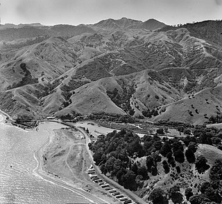
The Stillwater Ngākawau Line (SNL), formerly the Stillwater–Westport Line (SWL) and the Ngakawau Branch, is a secondary main line, part of New Zealand's national rail network. It runs between Stillwater and Ngakawau via Westport on the West Coast of the South Island. It was one of the longest construction projects in New Zealand's history, with its first section, at the south end, opened in 1889, and the beginnings of the Ngākawau Branch, at its Westport end, in 1875. The full line was completed in 1942. The only slower railway projects were Palmerston North to Gisborne, 1872 to 1942, and the Main North Line to Picton, 1872 to 1945.

The Moehau Range is the northernmost range on the Coromandel Peninsula, extending from the settlement of Colville, New Zealand northwards to the tip of the peninsula. Mount Moehau is the highest point of the range, at 892m above sea level.

Hikutaia is a locality on the Hauraki Plains of New Zealand. It lies on State Highway 26, south east of Thames and north of Paeroa. The Hikutaia River runs from the Coromandel Range through the area to join the Waihou River.

Matatoki is a locality on the Hauraki Plains of New Zealand. It lies on State Highway 26, south east of Thames and north of Paeroa. The Matatoki Stream runs from the Coromandel Range through the area to join the Waihou River.

The Manaia River is a river of the Coromandel Peninsula in New Zealand's North Island. It flows north from its sources in the Coromandel Range, reaching the Hauraki Gulf at Manaia Harbour, 10 kilometres (6 mi) southwest of Coromandel.
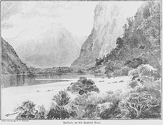
The Seaforth River is a river in New Zealand, flowing into Dusky Sound. About 9 km (5.6 mi) and 41 m (135 ft) up from Supper Cove in Dusky Sound is Lake Maree. The river rises about another 20 km (12 mi) to the north, on the slopes of the Black Giants, at about 1,300 m (4,300 ft). Like many former British Empire locations, it and its lakes have Scottish names.

The Tapu River is a river of the Coromandel Peninsula in New Zealand's North Island. It flows west from the Coromandel Range, reaching the Firth of Thames at the settlement of Tapu, approximately halfway between Thames and Coromandel.

The Te Mata River is a river of the Coromandel Peninsula in New Zealand's North Island. It flows west to reach the Firth of Thames at the small settlement of Te Mata, 25 kilometres (16 mi) south of Coromandel.
The Waitawheta River is a river of the Waikato Region of New Zealand's North Island. It flows from a point south-east of Mount Te Aroha in the Kaimai Range to the Karangahake Gorge at the foot of the Coromandel Peninsula to reach the Ohinemuri River at Karangahake, five kilometres east of Paeroa.
The Ngatapa Branch was a secondary branch line railway 18.5 kilometres (11.5 mi) long that for a short time formed part of the national rail network in Poverty Bay in the North Island of New Zealand. The Ngatapa branch diverged from the Moutohora branch line about 6 kilometres (3.7 mi) from Gisborne and ran a further 12.5 kilometres (7.8 mi) across the coastal flat to a terminus at Ngatapa. It was sometimes referred to as the Ngapata branch.
The Waikawau River is the name of two rivers of the Coromandel Peninsula in New Zealand's North Island. The more southerly flows generally west from its sources in the Coromandel Range, reaching the Firth of Thames at Waikawau Beach, almost 6 km (3.7 mi) north of Tapu. The other flows south east off the Moehau Range to join the Pacific at Waikawau. Both rivers were officially named on 21 June 2019.

Ngāruawāhia railway station was at the junction of the North Island Main Trunk line and its Glen Massey branch, serving Ngāruawāhia in the Waikato District of New Zealand, 74 mi (119 km) south of Auckland and 10 mi (16 km) north of Hamilton. It was opened with a special train from Auckland on Monday 13 August 1877. The next stations were Taupiri 6.5 km (4.0 mi) to the north and Horotiu 5.5 km (3.4 mi) to the south.
Okauia is a rural settlement and community located east of Matamata, in the Waikato region of New Zealand's North Island.
Ormondville is a locality in the Manawatū-Whanganui region of New Zealand's North Island. It is located inland, south of Waipukurau and west of Flemington, Hawke's Bay.

George Holdship (1839–1923) emigrated to Auckland in 1855 and became a businessman, mainly involved in timber logging and sawmills. His companies removed much of North Island’s native forest, initially kauri and later kahikatea. He moved to Sydney in 1913.

