
Arequipa is a department in southwestern Peru. It is bordered by the departments of Ica, Ayacucho, Apurímac and Cusco in the north, the Department of Puno in the east, the Department of Moquegua in the south, and the Pacific Ocean in the west. Its capital, also called Arequipa, is Peru's second-largest city.
Camaná is a province in the Arequipa Region, Peru. It borders the provinces of Caravelí, Condesuyos, Castilla, Caylloma, Arequipa and Islay.
Machucocha is a lake in Peru located in the Arequipa Region, Castilla Province, in the districts of Chachas and Orcopampa. It is situated at a height of about 4,659 m (15,285 ft), about 6.77 km long and 1.89 km at its widest point. Machucocha lies southeast of Huajrahuire and northwest of Pillune.

Puca Mauras is a volcano in the Andes of Peru, about 4,262 metres (13,983 ft) high. It is situated at the "Valley of the Volcanoes" in the Arequipa Region, Castilla Province, on the border of the districts of Andagua and Chilcaymarca. Puca Mauras lies in the western extensions of the Chila mountain range, northeast of the Ticsho and Yanamauras volcanoes.

Chilcayoc Grande is a volcano in the Andes of Peru, about 3,243 metres (10,640 ft) high. It is situated in the "Valley of the Volcanoes" in the Arequipa Region, Castilla Province, Andagua District. Chilcayoc Grande lies south-west of the Chachas Lake and south-east of the volcanoes Chilcayoc and Jechapita.
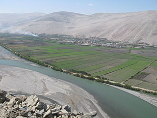
Andamayo River or Capiza is a river in Peru located in the Arequipa Region, Castilla Province, in the districts Aplao and Tipan. Its direction is mainly to the south where it meets Colca River as a right affluent. The confluence is north of the village Andamayo.
Qullpa is a mountain in the Andes of Peru, about 5,226.4 metres (17,147 ft) high. It is situated in the Arequipa Region, Castilla Province, on the border of the districts Ayo and Uñón. Qullpa lies south of the mountain Yanqha.

P'aqu Urqu is a mountain in the Andes of Peru, about 5,000 metres (16,404 ft) high. It is located in the Arequipa Region, Castilla Province, in the south of the Andagua District. P'aqu Urqu lies north-west of Yanawara and north of Huch'uy Yanawara.
Chuqllu Chuqllu or Chhuxllu Chhuxllu is a mountain in the Wansu mountain range in the Andes of Peru, about 5,000 metres (16,404 ft) high. It is situated in the Arequipa Region, Castilla Province, Orcopampa District.
Huayllatarpuna is a mountain in the Chila mountain range in the Andes of Peru, about 5,300 metres (17,388 ft) high. It is situated in the Arequipa Region, Castilla Province, Chachas District. Huayllatarpuna lies in a remote, mountainous area east of Orcopampa.la primera ascencion fue realizada por Rolando Huamani Cueva en agosto del 2017.
Condorcacha is a mountain in the Chila mountain range in the Andes of Peru, about 5,200 metres (17,060 ft) high. It is located in the Arequipa Region, Castilla Province, Chachas District. Condorcacha lies in a remote, mountainous area east of Orcopampa. It is situated southeast of Huayllatarpuna.
Huayllayoc is a mountain in the Chila in the Andes of Peru, about 5,300 metres (17,388 ft) high. It is located in the Arequipa Region, Castilla Province, Chachas District. Huayllayoc lies at the river Cacamayo which later is named Collpamayo. Its waters flow to the Colca River.
Usqullu is a mountain in the Andes of Peru, about 5,000 metres (16,404 ft) high. It is situated in the Arequipa Region, Castilla Province, Andagua District. Usqullu lies northwest of the peak of Wakapallqa (Huagapalca) and northeast of Puma Ranra and Usqullu Lake.
Puma Ranra is a mountain in the Andes of Peru, about 5,000 metres (16,404 ft) high. It is situated in the Arequipa Region, Castilla Province, Andagua District, and in the Condesuyos Province, Salamanca District. Puma Ranra lies southwest of Usqullu and Wakapallqa and Usqullu Lake, and northeast of the Coropuna volcano.
Llallawi is a mountain in the Andes of Peru, about 5,000 metres (16,404 ft) high. It is located in the Arequipa Region, Castilla Province, Andagua District. Llallawi lies west of Wakapallqa and southeast of Usqullu.
Minasniyuq is a mountain in the Andes of Peru, about 4,800 metres (15,748 ft) high. It is located in the Arequipa Region, Castilla Province, Andagua District. Minasniyuq lies south of Wakapallqa, southwest of Llallawi and southeast of Puma Ranra. It is situated at the Q'illu Q'illu valley (Jellojello).
P'isqi P'isqi is a mountain in the Andes of Peru, about 4,600 metres (15,092 ft) high. It lies in the Arequipa Region, Castilla Province, Andagua District. P'isqi P'isqi is situated west of Wakapallqa and Llallawi.
Posoco is a mountain in the Chila mountain range in the Andes of Peru, about 5,000 m (16,404 ft) high. It is situated in the Arequipa Region, Castilla Province, on the border of the districts of Chachas and Choco.

Puca Mauras is a 4,955-metre-high (16,257 ft) volcano in the Andes of Peru. It is situated in the Arequipa Region, Castilla Province, Chachas District. Puca Mauras lies in the western extensions of the Chila mountain range, west of a lake named Cochapunco.


