
Shimla is the capital and the largest city of the northern Indian state of Himachal Pradesh. In 1864, Shimla was declared the summer capital of British India. After independence, the city became the capital of East Punjab and was later made the capital city of Himachal Pradesh. It is the principal commercial, cultural and educational centre of the state.

Solan is a city in the Indian state of Himachal Pradesh and the district headquarters of Solan district. It is located 45.5 kilometres (28 mi) south of the state capital, Shimla. Solan has an average elevation of 1,550 metres (5,090 ft). The city is situated between Chandigarh and Shimla on the Kalka-Shimla National Highway-5. The narrow-gauge Kalka-Shimla railway passes through Solan. Located on the Punjab-Himachal Border, Solan is nestled in the Shivalik hills of the Himalayas.
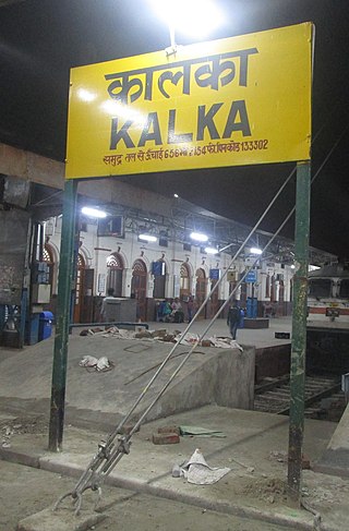
Kalka is a town in the Panchkula district of Haryana, India. It is near Panchkula city. The name of the town is derived from the Hindu goddess Kali. Kalka is situated in the foothills of the Himalayas and is a gateway to the neighbouring state of Himachal Pradesh; it is located on the National Highway 5 between Chandigarh and Shimla, and it is the terminus of the Kalka-Shimla Railway. To the south of Kalka is Pinjore, and the industrial village of Parwanoo is to the north on NH 22. Railways and Industrial development have led to a continuous urban belt from Pinjore to Parwanoo, but Kalka gained major economic benefits due to being the only highway destination until 2010 from Shimla. It is the tehsil of 253 nearby sub-villages. Nearby is Chandimandir Cantonment, where the Western Command of the Indian army is based. In 2013, the municipal committee of Kalka was dissolved and the administration was reassigned to Panchkula Municipal Corporation.

Manali is a resort town, near Kullu town in Kullu district in the Indian state of Himachal Pradesh. It is situated in the northern end of the Kullu Valley, formed by the Beas River. The town is located in the Kullu district, approximately 270 kilometres (170 mi) north of the state capital of Shimla and 544 kilometres (338 mi) northeast of the national capital of New Delhi. With a population of 8,096 people recorded in the 2011 Indian census Manali is the beginning of an ancient trade route through Lahaul (H.P.) and Ladakh, over the Karakoram Pass and onto Yarkand and Hotan in the Tarim Basin of China. Manali is a popular tourist destination in India and serves as the gateway to the Lahaul and Spiti district as well as the city of Leh in Ladakh.
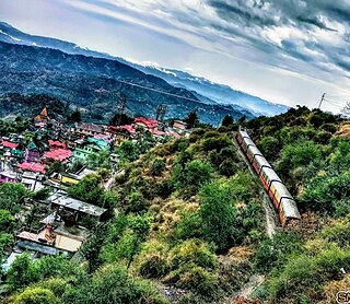
The Kalka–Shimla Railway is a 2 ft 6 in narrow-gauge railway in North India which traverses a mostly mountainous route from Kalka to Shimla. It is known for dramatic views of the hills and surrounding villages. The railway was built under the direction of Herbert Septimus Harington between 1898 and 1903 to connect Shimla, the summer capital of India during the British Raj, with the rest of the Indian rail system.

Barog is a hill station, near City of Solan in Solan district in the Indian state of Himachal Pradesh. The station lies on UNESCO World Heritage Site Kalka–Shimla Railway. Set in the mountains Barog is just 60 km (37 mi) from Chandigarh on the Kalka-Shimla highway.

Chail is a hill station in Solan district of Himachal Pradesh, India. It is 45 kilometres (28 mi) from Solan city and 44 kilometres (27 mi) from Shimla. It is known for its salubrious beauty and virgin forests. The Chail Palace is well known for its architecture: the palace was built as a summer retreat by the Maharaja of Patiala during the British Raj, on the land allotted to him by the British for the former's assistance in the Anglo-Nepalese War. The cricket ground and a polo ground which is there at an altitude of 2,444 m are owned by the erstwhile royal family of Patiala. It is the world's highest cricket ground.

Parwanoo or Parwanu is a municipal council in Solan district in the Indian state of Himachal Pradesh. It is an industrial town. It has Himachal's biggest wholesale market. First in 3rd-category of Swachh Vayu Sarvekshan award 2023. It borders Panchkula district of Haryana, and is after the towns of Pinjore and Kalka on the Chandigarh Simla Highway. In fact it is separated by a river bed from the town of Kalka. Pinjore to Parwanoo is almost a continuous urban belt. From Pinjore there is also a road to Baddi, another nearby industrial town of Himachal.
Sundar Nagar is a town and a municipal council in Mandi district in the Indian state of Himachal Pradesh. It was formerly a princely state, known as Suket.

Jaypee University of Information Technology (JUIT) is a private university in Solan, Himachal Pradesh. Established in 2002, Jaypee University of Information Technology is one of the four universities established by the Jaypee Group.
Himachal Pradesh, although railways and airways serve very limited transport needs, the road network of the state serves the transport needs of the people. Although, the geography of Himachal presents considerable challenge to the development of transport infrastructure, it has the highest road density among all the Hill States of India. Himachal also has 3 airports, 2 narrow gauge rail tracks and couple of other under-construction broad gauge railway tracks, but roads remain the main mode of transport.

Kasauli Brewery and Distillery, at Kasauli in Solan district of Himachal Pradesh state of India, was established in late 1920s during the British Raj by Edward Abraham Dyer. It started producing Asia's first beer brand, the "Lion Beer", and India's first single malt whisky, the ""Solan No. 1". Both of these brands are still in production. After the swap of brewery at Kasauli to Solan distillery and vice versa in 1835, presently Lion beer is produced at Solan and Solan No.1 whisky is produced at the Kasauli distillery using some of the original equipment including the copper pot still. The production of Lion beer was moved 25 km east to Solan Brewery at Solan, due to water scarcity, after civilian Kasauli hill station resort town came up around the brewery. Lion beer was originally an India Pale Ale (IPA), but the beer style was changed to lager in 1960s.
Junga is a tehsil in the Shimla district of Himachal Pradesh, India. Its original name is Jūnga.

Kandaghat is a small town and tehsil (sub-district), near Solan city in the Solan district of Himachal Pradesh, India which is on the Kalka-Shimla National Highway No. 22. The road to the famous tourist destination of Chail turns from Kandaghat which is at a distance of 29 km. The capital of Himachal Pradesh, Shimla is at a distance of 30 km.

The Shimla Chandigarh Expressway is an under construction 120 kilometres (75 mi) long expressway connecting Chandigarh to Shimla stretch of National Highway 5 (India).The four laning project involves the creation of 11 tunnels between Maliana (Shimla) and Kothi to help reduce the distance by 19 km. The total length of the tunnels will be 9.5 km. The two longest tunnels will be of 2.27 km each between Taradevi and Shogi and Kandaghat and Solan. The state government wants that the highway be realigned and include more tunnels to reduce the distance by another 20 km. The Himalayan expressway stretch of it was opened in June 2021.
Kiarighat, Himachal Pradesh, India, is a small hill station situated at Kalka-Shimla National Highway, where tourists can stay for a while or stay overnight. The JP university is located at about 8 km from here.

Dharampur is a town located in Solan district of Himachal Pradesh. It is located in Kasauli tehsil, about 65 km from Shimla and 15 km from Kasauli on the National Highway 22. It is also connected by the Kalka Shimla Railway Line. It houses the first tuberculosis sanatorium in North India. C R.P.F. camp on N.H. 22 on Shimla Road.
Totu is one of the major suburbs of Shimla city, in the state of Himachal Pradesh, India. It is under the administration of the Shimla Municipal Corporation.

National Highway 5 (NH5) is a primary national highway in India, running from West to East, connecting Firozpur in Punjab to the Sino-Indian border at Shipki La. The highway passes through Moga, Jagraon, Ludhiana, Mohali, Chandigarh, Panchkula, Kalka, Solan, Shimla, Theog, Narkanda, Kumarsain, Rampur Bushahr and continues along the Sutlej River till its terminus near the Tibet border.

Barog Railway Station is a small railway station in the Solan district in the Indian state of Himachal Pradesh. The station lies on UNESCO World Heritage Site Kalka–Shimla Railway. The station is located at an altitude of 1,531 metres (5,023 ft) above mean sea level, 42.14 km from Kalka.


