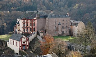
The Eifel is a low mountain range in western Germany, eastern Belgium and northern Luxembourg. It occupies parts of southwestern North Rhine-Westphalia, northwestern Rhineland-Palatinate and the southern area of the German-speaking Community of Belgium.
The Eifelkreis Bitburg-Prüm is a district in Rhineland-Palatinate, Germany. It is bounded by Luxembourg, Belgium and the districts of Euskirchen, Vulkaneifel, Bernkastel-Wittlich and Trier-Saarburg.
Vulkaneifel is a district (Kreis) in the northwest of the state Rhineland-Palatinate, Germany. It is the least densely populated district in the state and the fourth most sparsely populated district in Germany. The administrative centre of the district is in Daun. Neighboring districts are Euskirchen, Ahrweiler, Mayen-Koblenz, Cochem-Zell, Bernkastel-Wittlich, and Bitburg-Prüm.

Bitburg is a city in Germany, in the state of Rhineland-Palatinate approximately 25 km (16 mi.) northwest of Trier and 50 km (31 mi.) northeast of Luxembourg city. The American Spangdahlem Air Base is nearby.

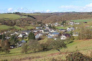
Meisburg is an Ortsgemeinde – a municipality belonging to a Verbandsgemeinde, a kind of collective municipality – in the Vulkaneifel district in Rhineland-Palatinate, Germany. It belongs to the Verbandsgemeinde of Daun, whose seat is in the like-named town. In Meisburg, a Moselle Franconian dialect is spoken.
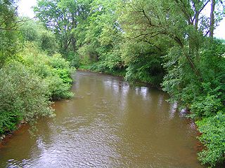
The Kyll, noted by the Roman poet Ausonius as Celbis, is a 128-kilometre-long (80 mi) river in western Germany, left tributary of the Moselle. It rises in the Eifel mountains, near the border with Belgium and flows generally south through the towns Stadtkyll, Gerolstein, Kyllburg and east of Bitburg. It flows into the Moselle in Ehrang, a suburb of Trier.

Speicher is a town in the county of Bitburg-Prüm, in Rhineland-Palatinate, Germany. It is situated in the Eifel, on the river Kyll, approximately 10 km south-east of Bitburg and 29 km north of Trier. It has 3,624 inhabitants and is next to the Spangdahlem Air Base which is home of the 52d Fighter Wing. There is a small monument to the men who died in the First and Second World Wars at the western end of the town. East of the monument is an open area for shopping and other events. Directly to the south is the parish church of St. Philip and St. James.
Dahlem is a municipality in the district of Euskirchen. It has the lowest population density and population of all municipalities of in the state of North Rhine-Westphalia, Germany. It is located in the Eifel hills, approx. 35 km south-west of Euskirchen. The small medieval town Kronenburg is part of the municipality.
Kyllburg is a town in the Waldeifel region in the district of Bitburg-Prüm, in Rhineland-Palatinate, Germany. It is situated in the Eifel mountains, on the river Kyll, approximately 10 km north-east of Bitburg.
The Éislek, also known by its German name Ösling or Oesling, is a region covering the northern part of both the Grand Duchy of Luxembourg and Eifelkreis Bitburg-Prüm, within the greater Ardennes area that also covers parts of Belgium and France. The Éislek covers 32% of the territory of Luxembourg; to the south of the Éislek lies the Gutland, which covers the remaining 68% of the Grand Duchy as well as the southern part of the Eifelkreis Bitburg-Prüm.

Biersdorf am See is a municipality in the district of Bitburg-Prüm, in Rhineland-Palatinate, western Germany.
Utscheid is a municipality in the district of Bitburg-Prüm, in Rhineland-Palatinate, western Germany.
The Schnee Eifel is a heavily wooded landscape in Germany's Central Uplands, up to 699.1 m above sea level (NHN), that forms part of the western Eifel in the area of the German-Belgian border. The name may have been derived in the 19th century from the Schneifel chain of hills, which had nothing to do with snow (Schnee), but with the name for a forest swathe (Schneise).

The Volcanic Eifel or Vulkan Eifel, also known as the East Eifel Volcanic Field (EEVF), is a region in the Eifel Mountains in Germany that is defined to a large extent by its volcanic geological history. Characteristic of this volcanic field are its typical explosion crater lakes or maars, and numerous other signs of volcanic activity such as volcanic tuffs, lava streams and volcanic craters like the Laacher See. The Volcanic Eifel is still volcanically active today. One sign of this activity is the escaping gases in the Laacher See.

Windsborn Crater Lake is a water-filled volcanic crater in the Eifel mountains in Germany. It is located near Bettenfeld in the county of Bernkastel-Wittlich and in the state of Rhineland-Palatinate, and belongs to a group of four craters known as the Mosenberg Crater Row, named after the village of Mosenberg.
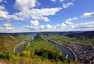
The Moselle Eifel forms the southeastern strip of the East Eifel to the left of the Moselle from the city of Trier downstream as far as Moselkern; in the southeast it does not reach as far as the Moselle Valley. It lies exclusively within the German state of Rhineland-Palatinate and is a truncated highland, roughly half of which is forested.

Bitburg-Erdorf station is a station on the Eifel Railway in Bitburg in the German state of Rhineland-Palatinate. The Nims–Sauer Valley railway (Nims-Sauertalbahn) branched off here to the now closed Bitburg Town station, the remaining part of which is only used for freight traffic and occasional excursion trains. Today Bitburg-Erdorf station is the only station in Bitburg that is served by regular passenger services.

Ehrang station is, after Trier Hauptbahnhof, the second most important station in the city of Trier in the German state of Rhineland-Palatinate. The station forms a railway junction with a former marshalling yard that is still partly used as a freight yard. At the station, the Eifel Railway from Cologne connects with the Koblenz–Trier railway. Until 1983, Ehrang station was also the starting point of the Trier West Railway to Igel that connected with Wasserbillig / Luxembourg.

The Burberg, also called the Buerberg and Bürberg, is a hill, 528.5 m above sea level (NHN), in the Eifel mountains in Germany. It rises near Schutz in the county of Vulkaneifel in the state of Rhineland-Palatinate.

The Bundesstraße 257 is a German federal highway which leads from the connection to the A 565 near the Kreuz Meckenheim in a south-westerly direction through the Eifel to the border with Luxembourg in Echternacherbrück.