
The Snoqualmie River is a 45-mile (72 km) long river in King County and Snohomish County in the U.S. state of Washington. The river's three main tributaries are the North, Middle, and South Forks, which drain the west side of the Cascade Mountains near the town of North Bend and join near the town of Snoqualmie just above the Snoqualmie Falls. After the falls the river flows north through rich farmland and the towns of Fall City, Carnation, and Duvall before meeting the Skykomish River to form the Snohomish River near Monroe. The Snohomish River empties into Puget Sound at Everett. Other tributaries of the Snoqualmie River include the Taylor River and the Pratt River, both of which enter the Middle Fork, the Tolt River, which joins at Carnation, and the Raging River at Fall City.

The Nooksack River is a river in the northwest part of the U.S. state of Washington. It drains an area of the Cascade Range around Mount Baker, near the Canada–US border. The lower river flows through a fertile agricultural area before emptying into Bellingham Bay and, via the Strait of Juan de Fuca and the Strait of Georgia, the Pacific Ocean. The river begins in three main forks, the North Fork, Middle Fork, and South Fork. The North Fork is sometimes considered the main river. Including the North Fork, the Nooksack is approximately 75 miles (121 km) long. All three forks originate in the Mount Baker Wilderness.

The Sauk River is a tributary of the Skagit River, approximately 45 miles (72 km) long, in northwestern Washington in the United States. It drains an area of the high Cascade Range in the watershed of Puget Sound north of Seattle. The river is a popular destination for fly fishing. It is a National Wild and Scenic River.
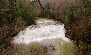
The Falling Water River is a 46.8-mile-long (75.3 km) stream in the east-central portion of Middle Tennessee in the United States. It rises just west of Monterey at the edge of the Cumberland Plateau, and traverses the Eastern Highland Rim before dropping off to the Nashville Basin and emptying into Center Hill Lake along the Caney Fork. The river is noted for the 136-foot (41 m) Burgess Falls, which it spills over near the end of its course.
Eagle Creek is a creek located in Hood River County, Oregon, in the Columbia River Gorge. A tributary of the Columbia River, the creek flows for approximately 15 miles (24 km) from the Thrush Pond between Eagle Butte and Tanner Butte to its mouth near Bonneville Dam. The East Fork Eagle Creek is a major tributary that begins at Wahtum Lake and joins the main stem approximately 2/3 the way between the Thrush Pond and the Columbia River, separated by Indian Mountain.

The Quinault River is a 69-mile (111 km) long river located on the Olympic Peninsula in the U.S. state of Washington. It originates deep in the Olympic Mountains in the Olympic National Park. It flows southwest through the "Enchanted Valley" to opposite Quinault Canyon. Several miles above Lake Quinault the river is joined by its main tributary, the North Fork Quinault River. The main stem Quinault River above this confluence is sometimes called the East Fork Quinault River. Below the confluence the river marks the boundary of Olympic National Park for several miles before emptying into Lake Quinault. After the lake, the Quinault River flows southwest, reaching the Pacific at Taholah. From Lake Quinault to the ocean, the river is contained within the Quinault Indian Reservation.
The Salmon River is a tributary of the Queets River in U.S. state of Washington.

The Sultan River is a river in Snohomish County in the U.S. state of Washington. It is a tributary of the Skykomish River, which it joins at the town of Sultan, Washington. The river is dammed in its upper third by Culmback Dam to form Spada Lake.
The Taylor River is a river in King County in Washington.

The Miller River is a river in King County, Washington. Named for 1890s prospector John Miller, it is a tributary of the Skykomish River, which it joins near the community of Miller River. The Miller River is about 3.5 miles (5.6 km) long from the confluence of its main tributaries, the East Fork and West Fork. Miller River Campground is located just downriver from the confluence.
The Little Mashel River is a river in Pierce County, Washington. It is a tributary of the Mashel River, and enters the Mashel just 380 feet (116 m) downstream from the Eatonville, Washington, city limits. It is noted for its canyon and the three waterfalls.
The Moclips River is a river in the U.S. state of Washington. It is about 12 miles (19 km) long. Its main tributary, the North Fork Moclips River, is longer than the main stem. The length of the North Fork, along with the lower main stem below the North Fork's confluence, is 17 miles (27 km). The drainage basin of the Moclips River is 22.4 square miles (58 km2) in area.
The Tye River is a river in the U.S. state of Washington. It rises near Stevens Pass in the Cascade Mountains and flows west, joining the Foss River to form the South Fork Skykomish River. Its waters eventually empty into Puget Sound near Everett via the Skykomish River and Snohomish River. U.S. Route 2 follows the river's entire length. A BNSF Railway line follows most of the river except near the pass where the tracks use the Cascade Tunnel. Powerlines run by the Bonneville Power Administration (BPA) follow the Tye River west of Tunnel Creek.

The Beckler River is a tributary of the South Fork Skykomish River in the U.S. state of Washington in the United States.
The Rapid River is a tributary of the Beckler River in the U.S. state of Washington in the United States. It is 13 miles (21 km) long, with a drainage basin of 41 square miles (106 km2).
Muddy Boggy Creek, also known as the Muddy Boggy River, is a 175-mile-long (282 km) river in south central Oklahoma. The stream headwaters arise just east of Ada in Pontotoc County. It is a major tributary of the Red River in south central Oklahoma. Clear Boggy Creek is a major tributary which enters the Muddy Boggy at a location known as River Mile 24 in Choctaw County. The river is inhabited by over one hundred species of fish.

The Middle Fork Kings River is a 37.2-mile (59.9 km) tributary of the Kings River in Kings Canyon National Park, California, in the southern Sierra Nevada. Draining 318 square miles (820 km2) – almost all of it wilderness – the Middle Fork is one of the largest wholly undeveloped watersheds in the state, with no dams or paved roads within its basin. The entire length of the Middle Fork is designated a National Wild and Scenic River.

Poso Creek or Posey Creek is an 87.9-mile (141.5 km) intermittent stream in Kern County, California.

The East Fork Kaweah River is a 22.5-mile (36.2 km) tributary of the Kaweah River in Tulare County, California. The river begins below Farewell Gap at the head of the Mineral King Valley in Sequoia National Park. It flows north through mountain meadows then turns west through a steep canyon, where it forms a waterfall about 200 feet (61 m) high known alternately as "Mineral King Falls" or "Three-Falls-Below-The-Gate". It then receives its largest tributary, Horse Creek, from the left before leaving the national park and turning northwest. It joins the Kaweah River about 2 miles (3.2 km) upstream of Three Rivers.


