
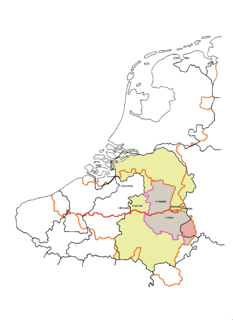
Flanders is the Dutch-speaking northern portion of Belgium and one of the communities, regions and language areas of Belgium. However, there are several overlapping definitions, including ones related to culture, language, politics and history, and sometimes involving neighbouring countries. The demonym associated with Flanders is Fleming, while the corresponding adjective is Flemish. The official capital of Flanders is the City of Brussels, although the Brussels-Capital Region has an independent regional government. The government of Flanders only oversees the community aspects of Flanders life in Brussels, such as Flemish culture and education.
Limburg is the southernmost of the 12 provinces of the Netherlands. The province is in the southern part of the country, stretched out from the north, where it touches the province of Gelderland. Its northern part has the province of North Brabant to its west. Its long eastern boundary is the international border with the German state of North Rhine-Westphalia. Much of the western and southern boundary is the international border with the Belgium, much of it delineated by the Meuse river, across from the Belgian Liège Province and the Belgian province also named Limburg. The Vaalserberg is on the extreme south-eastern point, marking the tripoint of the Netherlands, Germany and Belgium.
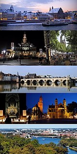
Maastricht is a city and a municipality in the southeastern Netherlands. It is the capital and largest city of the province of Limburg. Maastricht is located on both sides of the Meuse, at the point where the Jeker joins it. It is adjacent to the border with Belgium.

The Meuse or Maas is a major European river, rising in France and flowing through Belgium and the Netherlands before draining into the North Sea from the Rhine–Meuse–Scheldt delta. It has a total length of 925 km.

The United Kingdom of the Netherlands is the unofficial name given to the Kingdom of the Netherlands as it existed between 1815 and 1839. The United Netherlands was created in the aftermath of the Napoleonic Wars through the fusion of territories that had belonged to the former Dutch Republic, Austrian Netherlands, and Prince-Bishopric of Liège in order to form a buffer state between the major European powers. The polity was a constitutional monarchy, ruled by William I of the House of Orange-Nassau.

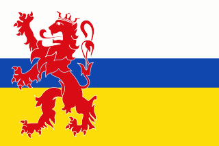
Limburg is a province in Belgium. It is the easternmost of the five Dutch-speaking provinces that together form the Region of Flanders, one of the three main political and cultural sub-divisions of modern Belgium.

The Walloon Region, usually simply referred to as Wallonia, is one of the three Regions of Belgium—alongside Flanders and Brussels.

Roermond is a city, a municipality, and a diocese in the southeastern part of the Netherlands.

Liège is the easternmost province Belgium. It lies in the country's Wallonia region.
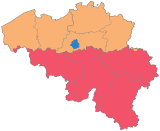
The country of Belgium is divided into three regions. Two of these regions, the Flemish Region or Flanders, and Walloon Region, or Wallonia, are each subdivided into five provinces. The third region, the Brussels Capital Region, is not divided into provinces, as it was originally only a small part of a province itself.

Hasselt is a Belgian city and municipality, and capital and largest city of the province of Limburg in the Flemish Region of Belgium. The Hasselt municipality includes the original city of Hasselt, plus the old communes of Sint-Lambrechts-Herk, Wimmertingen, Kermt, Spalbeek, Kuringen, Stokrooie, Stevoort and Runkst, as well as the hamlets and parishes of Kiewit, Godsheide and Rapertingen.
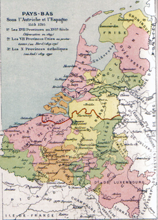
The Southern Netherlands, also called the Catholic Netherlands, was the part of the Low Countries largely controlled by Spain (1556–1714), later Austria (1714–1794), and occupied by France (1794–1815). The region also included a number of smaller states that were never ruled by Spain or Austria: the Prince-Bishopric of Liège, the Imperial Abbey of Stavelot-Malmedy, the County of Bouillon, the County of Horne and the Princely Abbey of Thorn. The Southern Netherlands were part of the Holy Roman Empire until the whole area was annexed by Revolutionary France.

The Jeker is a river in Belgium and in the Netherlands. It is a left-bank tributary to the river Meuse. The source of the Jeker is near the village of Geer, in the Belgian province of Liège. The river is approximately 54 kilometres (34 mi) long, of which about 50 kilometres (31 mi) is in Belgium and 4 kilometres (2.5 mi) in the Netherlands, where it flows into the river Meuse at Maastricht (Netherlands).

The Duchy of Limburg or Limbourg was an imperial estate of the Holy Roman Empire. Much of the area of the duchy is today located within Liège Province of Belgium, with a small portion in the municipality of Voeren, an exclave of the neighbouring Limburg Province. Its chief town was Limbourg-sur-Vesdre, in today's Liège Province.
The Hesbaye, or Haspengouw is a traditional cultural and geophysical region in eastern Belgium. It is a loamy plateau region which forms a watershed between the Meuse and Scheldt drainage basins. It has been one of the main agricultural regions in what is now Belgium since before Roman times, and specifically named in records since the Middle Ages, when it was an important Frankish pagus or gau, called Hasbania in medieval Latin.

The European route E 314 is a road in Europe and a part of the United Nations International E-road network. Approximately 125 kilometers (78 mi) long, it connects the Belgian university city of Leuven with Aachen, Charlemagne's capital during the early ninth century, and today a bustling commercial centre in Germany's North Rhine-Westphalia.

The Meuse–Rhine Euroregion is a Euroregion created in 1976, with judicial status achieved in 1991. It comprises 11.000 km² and has around 3.9 million inhabitants around the city-corridor of Aachen–Maastricht–Hasselt–Liège. The seat of the region has been in Eupen, Belgium since 1 January 2007. Within a wider context, the region is part of what is called the Blue Banana European urbanisation corridor.
The Belgian province of Limburg in Flanders is a region which has had many names and border changes over its long recorded history. Its modern name is a name shared with the neighbouring province of the Netherlands, with which it was for a while politically united. The two provinces received their modern name after 1815, based upon the name of the medieval Duchy of Limburg, which had actually been in what is now neighbouring Wallonia, centred upon the town of Limbourg on the Vesdre.
The Civitas Tungrorum was a large Roman administrative district dominating what is now eastern Belgium and the southern Netherlands. In the early days of the Roman Empire it was in the province of Gallia Belgica, but it later joined the neighbouring lower Rhine River border districts, within the province of Germania Inferior. Its capital was Aduatuca Tungrorum, now Tongeren.
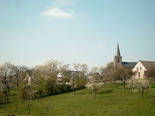
The village of Ében-Émael is a section of the Belgian municipality of Bassenge located in the Wallonia region in Liège Province. The village is located on the French-speaking side of the language border, next to Kanne on the Flemish side and not far from the border with the Netherlands near Maastricht. It is located at an altitude of 70 metres (230 ft) above sea level.