The Lane Cove River, a northern tributary of the Parramatta River, is a tide-dominated, drowned valley estuary west of Sydney Harbour, located in Sydney, New South Wales, Australia. The river is a tributary of the Parramatta River, winding through a bushland valley. It joins Parramatta River at Greenwich and Woolwich, where together they form an arm of Sydney Harbour.

Narrabeen is a beachside suburb in northern Sydney, in the state of New South Wales, Australia. Narrabeen is 23 kilometres north-east of the Sydney central business district, in the local government area of Northern Beaches Council and is part of the Northern Beaches region. This area was named Broken Bay by James Cook as he sailed by.

Macquarie Park is a suburb in northern Sydney, New South Wales, Australia. Macquarie Park is located 15 kilometres north-west of the Sydney central business district in the local government area of the City of Ryde. Macquarie Park is part of the Northern Suburbs region.

East Ryde is a suburb in the Northern Suburbs of Sydney, in the state of New South Wales, Australia. East Ryde is located 12 kilometers north-west of the Sydney central business district, in the local government area of the City of Ryde. East Ryde sits on the western bank of the Lane Cove River. East Ryde shares the postcode of 2113 with adjacent suburb of North Ryde though it does not have a Post Office of its own.

Sheldon Forest is a pocket of urban bushland located 17 kilometres (11 mi) north-west of Sydney, Australia in a narrow valley between Turramurra and Pymble.

The Cumberland Plain is a relatively flat region lying to the west of Sydney CBD in New South Wales, Australia. Cumberland Basin is the preferred physiographic and geological term for the low-lying plain of the Permian-Triassic Sydney Basin found between Sydney and the Blue Mountains, and it is a structural sub-basin of the Sydney Basin.

Newington Armory is a heritage-listed former Royal Australian Navy armament depot, now used for tourism purposes, at Holker Street, Sydney Olympic Park, Cumberland Council, New South Wales, Australia. It was built from 1897 by the Royal Australian Navy. It is also known as Millennium Heritage Parklands Precinct, RAN Armament Depot Newington, Royal Australian Navy Armament Depot (RANAD), Newington Nature Reserve and Sydney Olympic Games. The property is owned by the Sydney Olympic Park Authority. It was added to the New South Wales State Heritage Register on 14 January 2011.

The Northern Suburbs is the metropolitan area on the northern bank of the Parramatta River in Sydney, New South Wales, Australia beginning with suburbs in line with or east of West Pennant Hills and ending with suburbs west of the Lane Cove National Park, south of Hornsby. This area includes suburbs in the local government areas of Hornsby Shire, City of Ryde, the Municipality of Hunter's Hill, and parts of the City of Parramatta.
The Duck River is a perennial stream and southern tributary of the Parramatta River, in Sydney, New South Wales, Australia.
Coxs Creek, a watercourse of the Cooks River catchment, is located in the Inner West of Sydney, in New South Wales, Australia.

The Dalrymple-Hay Nature Reserve is a protected nature reserve that is located in the northerns suburbs of Sydney, New South Wales, Australia. The 10.768-hectare (26.61-acre) reserve is situated in the suburb of St Ives, 15 kilometres (9.3 mi) from the Sydney central business district.
The Blue Gum High Forest of the Sydney Basin Bioregion is one of six main indigenous forest communities of Sydney, Australia. It has been classified as critically endangered, under the New South Wales government's Threatened Species Conservation Act 1995. The principal canopy trees in this forest community are Sydney blue gum and blackbutt which are usually seen between 20 and 40 metres tall. 180 species of indigenous plants have been identified at Dalrymple-Hay Nature Reserve.
The Cooks River/Castlereagh Ironbark Forest (CRCIF) is an area of open forest and low woodland in the Sydney Basin Bioregion, which was gazetted as a critically Endangered Ecological Community on 10 May 2002. There are just 1011 hectares left. It is dominated by Broad-leaved Ironbark and Paperbark. The main threat is further clearing for development, as well as weed invasion, inappropriate fire regime, damage from vehicles, and impacts from surrounding development. Fencing also prevents wildlife movement and increases injuries and deaths. There is also the potential of Clay/shale extraction. Beverly Grove Bushland is 1.87ha of remnant bushland between Canterbury Golf Course and the M5 East Motorway. It is one of the larger patches of the CRCIF and has been preserved as an offset for the construction of the M5 East. Despite this, 1.4ha of the site has been proposed as a construction compound for Stage 2: King Georges Road Interchange and New M5 of WestConnex.
The Cumberland Plain Woodland is one of six main indigenous forest communities of Sydney, New South Wales, Australia. Situated in the Cumberland Plain, it is made up of dry sclerophyll woodlands and forests, reminiscent of the Mediterranean forests. Currently, less than 6% of the Woodlands remain in small parts distributed across the western suburbs of Sydney, totaling only around 6400 hectares.

McKay Reserve is a small tract of remnant urban bushland in Palm Beach, parts of which contain the endangered ecological community (EEC) Pittwater and Wagstaffe Spotted Gum Forest. The reserve lies on a ridge on the Barrenjoey Peninsula and overlooks western Pittwater.

Prospect Nature Reserve is a nature reserve and recreational area that is situated in the western suburbs of Sydney, New South Wales, Australia, which incorporates the Prospect Reservoir, and also features picnic spots, lookouts, walking tracks and BBQ areas within the Australian bush. It is located within the Blacktown City local government area, but is also close to the boundaries of Cumberland Council and the City of Fairfield.

The ecology of Sydney, located in the state of New South Wales, Australia, is diverse for its size, featuring biomes such as wet and dry sclerophyll forests or woodlands, shrublands, subtropical and evergreen temperate rainforests, heathlands, wetlands and grasslands, with the combination of climate, topography, moisture, and soil influencing the dispersion of these ecological communities across a height gradient from 0 to 200 metres. There are many hiking trails, paved and unpaved roads for exploring the many different biomes and ecosystems.

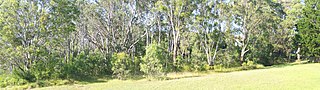
Wallumatta Nature Reserve is a small bushland area in suburban Sydney, Australia. Comprising 6.195 hectares, it is surrounded by the residential suburb of East Ryde. Once part of the Field of Mars of 1804, the reserve is the largest surviving area of Sydney Turpentine-Ironbark Forest, an endangered ecosystem. Soils are based on Ashfield Shale and Hawkesbury Sandstone.