Guildford, New South Wales

Last updated

Guildford
Sydney,  New South Wales
Guildford St Marys Anglican Church.JPG
St Marys Anglican Church
Guildford, New South Wales
Map
Population24,091 (2021 census) [1]
Established1817
Postcode(s) 2161
Elevation29 m (95 ft)
Location27 km (17 mi) west of Sydney CBD
LGA(s) Cumberland City Council
State electorate(s)
Federal division(s)
Suburbs around Guildford:
Woodpark Merrylands West Merrylands
Guildford West Guildford South Granville
Yennora Old Guildford Chester Hill

Guildford is a suburb of Sydney, in the state of New South Wales, Australia. Guildford is located 27 kilometres west of the Sydney central business district, in the local government area of Cumberland City Council. Guildford is part of the Western Sydney region. Guildford is the home of the first KFC in Australia. [2]

Contents

History

Guildford was named in 1837, in honour of the Earl of Guildford. [3]

Aboriginal culture

Prior to colonisation, the Dharug people lived in small groups across the Cumberland Plain, including in the area which is now the Woodville Ward. The Bidjigal clan lived around the area which is now Guildford.

European settlement

Lieutenant Samuel North was granted 640 acres (2.6 km2) in this area in 1817 and named his property Guildford, as he had ties with the Earl of Guildford. A small hamlet developed in the area around Woodville Road and by 1870 a school had opened here and a church was built here in the 1880s. After the railway station opened in 1876, a new settlement developed around it and the former settlement became known as Old Guildford. [3]

Post-war immigration

Guildford is one of a small number of Sydney suburbs which houses the most significant portion of the Arabic-speaking diaspora in Australia. The first arrivals were from Lebanon in the 1970s following its civil war and since then numbers have grown to make Guildford one of Australia's true multicultural places, with many other resident nationalities and identities adding to the harmonious mix.

Heritage listings

Guildford is home to historic house Linnwood, 11–35 Byron Road, which is listed as a building of state significance on the New South Wales Heritage Office State Heritage Register. [4] Linnwood Hall was the Home of George McCredie until his death in 1903. He was a prominent business man (whose brother Arthur was an architect of Sydney's Mark Foy's department store – now Downing Legal Centre), was a Member of Parliament and also Mayor of Municipality of Prospect and Sherwood from 1892–1895.

Sydney's oldest and perhaps most visible above ground water supply pipeline, the heritage-listed Guildford West pipehead and water supply canal which can be seen at Frank Street, [5] skirts most of the southern boundary of Guildford, and stretches from the pipe head at Guildford West to Potts Hill Reservoir near Bankstown. It passes under several streets, as well as Woodville Road (the main arterial road between Liverpool, New South Wales and Parramatta) and over the railway line south of the railway station. The three pipes, each 1.8 metres in diameter were built separately in 1888, 1901 and 1925.

Location

Located in Cumberland Council, Guildford has a variety of schools, parks and sports grounds, pools, a locally significant retail precinct and several neighbourhood shops, a train station with parking, several churches and Turkish mosques and is on bus routes to Bass Hill, Yagoona, Bankstown, Harris Park, Merrylands, Parramatta, Granville, Liverpool, Auburn and Fairfield. The suburb also has notable commercial and industrial areas.

Transport

Guildford Railway Station GuildfordRailwayStation1.JPG
Guildford Railway Station

Guildford railway station is on the Old Main South. Guildford CBD is located around Guildford Railway Station.

Commercial area

Major industrial and commercial areas are located in Guildford Rd, Ferndell St - heading to Chester Hill, Cann St and surrounding streets west side near Guildford Railway Station which run into Yennora (which is 80% industrial). Some buildings in the main streets are in art deco style, as they were constructed in the 1930s.[ citation needed ] Guildford Rd is ornamented by crepe myrtles.

Parks

There are several serviceable parks in Guildford.

McCredie Park

Bounded by Guildford Rd, Tamplin Rd, Fowler Rd and Dennistoun Rd. This park complex consists of the local Swimming Centre and sporting fields. Named after George McCredie and was part of his land grant. He was a prominent local business man, Member of Parliament and Mayor of Municipality of Prospect and Sherwood 1892-1895 (now City of Holroyd).

The Swim Centre consists of an indoor all year round heated pool, outdoor pools, a skateboard track and ample parking. The Sporting fields are run by the Guildford Leagues Club.

Guildford Park

Bounded by Railway Terrace, Bursill St and Marian St and Guildford Overbridge. This complex houses the local Bowling Club and Sports grounds and has a hall to rent. Local football, cricket and soccer teams use the main oval.

Campbell Hill Pioneer Reserve

Only main entry off Campbell Hill Rd. Local Pedestrian access is at end of Dudley Rd. Has an area of 19ha with BBQ with shelters, toilets, a mini wetland, half basketball court, and sculptures. The park has some bush areas.

Named after John Thomas Campbell (1770 – 1830) this park is a part of his original Land Grant of 1823 of 1000ac. He was Secretary to Governor Macquarie from 1810–1820, Provost Marshal from 1812-1822. He was a Founder of the Bank of New South Wales (1816-1817) was first President of the Board of Directors.

Woodville Public Golf Course

Only entry off Rawson Rd. Bounded by Woodville Rd, Water Supply Pipeline and Barbers Rd. This 18 hole golf course was also part of John Thomas Campbells Land Grant of 1000ac.

Demographics

At the 2021 census, there were 24,091 residents in Guildford. 45.3% of people were born in Australia, with the top other countries of birth being Lebanon 10.3%, Afghanistan 4.6%, China 3.2%, Pakistan 2.7% and Iraq 2.2%.

The most common ancestries were Lebanese 24.2%, Australian 12.8%, English 9.2%, Chinese 6.6% and Afghan 3.7%.

The most common responses for religion in Guildford were Islam 39.1%, Catholic 21.4%, No Religion 9.9%, Not stated 10.3% and Buddhism 2.8%.

A total of 25.5% of people spoke only English at home. Other languages spoken at home included Arabic 30.2%, Mandarin 3.2%, Hazaraghi 3.2%, Urdu 2.6% and Dari 2.6%. [1]

Notable people

Related Research Articles

<span class="mw-page-title-main">Granville, New South Wales</span> Suburb of Sydney, New South Wales, Australia

Granville is a suburb in Western Sydney, in the state of New South Wales, Australia. Granville is located 18 kilometres (11 mi) west of the Sydney central business district, split between the local government areas of Cumberland City Council and the City of Parramatta.

<span class="mw-page-title-main">Beverly Hills, New South Wales</span> Suburb of Sydney, New South Wales, Australia

Beverly Hills is a southern suburb of Sydney, in the state of New South Wales, Australia. Beverly Hills is located 15 kilometres southwest of the Sydney central business district and is part of the St George area and is split between the local government areas of the Georges River Council and the City of Canterbury-Bankstown. The postcode is 2209, which it shares with neighbouring Narwee.

<span class="mw-page-title-main">Carlingford, New South Wales</span> Suburb of Sydney, New South Wales, Australia

Carlingford is a suburb of Sydney, in the state of New South Wales, Australia. Carlingford is 22 kilometres north-west of the Sydney central business district in the local government area of City of Parramatta. Carlingford sits at the meeting point of Northern Sydney and Western Sydney sitting on both sides of Pennant Hills Road which generally acts as a divider of the two regions. While being part of City of Parramatta, it is sometimes referred to as being part of the Hills District.

<span class="mw-page-title-main">Greater Western Sydney</span> Region of the metropolitan area of Sydney, Australia

Greater Western Sydney (GWS) is a large region of the metropolitan area of Greater Sydney, New South Wales (NSW), Australia that generally embraces the north-west, south-west, central-west, far western and the Blue Mountains sub-regions within Sydney's metropolitan area and encompasses 11 local government areas: Blacktown, Blue Mountains, Camden, Campbelltown, Cumberland, Fairfield, Hawkesbury,Liverpool, Parramatta, Penrith and Wollondilly. It includes Western Sydney, which has a number of different definitions, although the one consistently used is the region composed of ten local government authorities, most of which are members of the Western Sydney Regional Organisation of Councils (WSROC). The NSW Government's Office of Western Sydney calls the region "Greater Western Sydney".

<span class="mw-page-title-main">Lewisham, New South Wales</span> Suburb of Sydney, New South Wales, Australia

Lewisham is a suburb in the Inner West of Sydney, in the state of New South Wales, Australia. Lewisham is located 7 kilometres south-west of the Sydney central business district, in the local government area of Inner West Council.

<span class="mw-page-title-main">Seven Hills, New South Wales</span> Suburb of Sydney, New South Wales, Australia

Seven Hills is a suburb in the Greater Western Sydney region of Sydney, in the state of New South Wales, Australia, located 33 kilometres North West of the Sydney central business district. Seven Hills is within the local government areas of the City of Parramatta and Blacktown City councils.

<span class="mw-page-title-main">Wentworthville, New South Wales</span> Suburb of Sydney, New South Wales, Australia

Wentworthville is a suburb in Sydney, in the state of New South Wales, Australia. Wentworthville is located 27 kilometres west of the Sydney central business district and is part of the Greater Western Sydney region. Wentworthville is split between the local government areas of the City of Parramatta and the Cumberland Council. Wentworthville is colloquially known as 'Wenty'.

<span class="mw-page-title-main">Villawood, New South Wales</span> Suburb of Sydney, New South Wales, Australia

Villawood, a suburb of local government areas City of Canterbury-Bankstown and City of Fairfield, is 27 kilometres west of the Sydney central business district, in the state of New South Wales, Australia.

<span class="mw-page-title-main">Merrylands, New South Wales</span> Suburb of Sydney, New South Wales, Australia

Merrylands is a suburb in Western Sydney, Australia. Merrylands is located 25 kilometres west of the Sydney central business district and is in the local government area of the Cumberland City Council.

<span class="mw-page-title-main">Regents Park, New South Wales</span> Suburb of Sydney, New South Wales, Australia

Alternate uses: Regents Park (disambiguation)

<span class="mw-page-title-main">Old Guildford</span> Suburb of Sydney, New South Wales, Australia

Old Guildford is a suburb of Sydney, in the state of New South Wales, Australia 28 kilometres west of the Sydney central business district, in the local government area of the City of Fairfield. It is part of the Greater Western Sydney region.

<span class="mw-page-title-main">Chester Hill</span> City in New South Wales, Australia

Chester Hill, a suburb Cumberland Council is located 25 kilometres west of the Sydney central business district, in the state of New South Wales, Australia, and is part of Western Sydney, Chester Hill shares the postcode of 2162 with the neighbouring suburb of Sefton.

<span class="mw-page-title-main">Guildford West, New South Wales</span> Suburb of Sydney, New South Wales, Australia

Guildford West is a suburb of Sydney, in the state of New South Wales, Australia that is located 26 kilometres west of the Sydney central business district, in the local government area of the Cumberland City Council and is part of the Greater Western Sydney region. Guildford West shares the postcode of 2161 with the separate suburbs of Guildford and Old Guildford.

<span class="mw-page-title-main">Linnwood, Guildford</span> Historic site in New South Wales, Australia

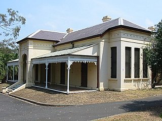
Linnwood is a heritage-listed former residence, school, local history museum and children's home and now historical society located at 11–35 Byron Road, Guildford in the Cumberland Council local government area of New South Wales, Australia. It was designed and built by George McCredie during 1891. It is also known as Linwood Hall, Lynwood Hall and Guildford Truant School. The property is owned by the Cumberland Council and the NSW Office of Environment and Heritage. It was added to the New South Wales State Heritage Register on 21 February 2003.

<span class="mw-page-title-main">Lower Prospect Canal Reserve</span> Australian nature reserve

The Lower Prospect Canal Reserve is a heritage-listed former farm and public water supply canal and now bushy corridor and nature reserve stretching 7.7 kilometres (4.8 mi) through the heart of suburban Sydney, New South Wales, Australia. The lineal corridor stretches from Prospect Reservoir to Sydney Water Pipehead at Albert Street, Guildford with the majority of the reserve located in Greystanes, which is a suburb within the Cumberland Council area.

George McCredie was an Australian politician.

<span class="mw-page-title-main">Cumberland City Council</span> Local government area in New South Wales, Australia

Cumberland Council, trading as Cumberland City Council, is a local government area located in the western suburbs of Sydney in the state of New South Wales, Australia. The Council was formed on 12 May 2016 from the merger of parts of the Cities of Auburn, Parramatta, and Holroyd.

<span class="mw-page-title-main">Guildford West pipehead and water supply canal</span> Historic site in New South Wales, Australia

The Guildford West pipehead and water supply canal is a heritage-listed sewerage infrastructure and water supply canal located at Frank Street, Guildford in the Cumberland Council local government area of New South Wales, Australia. It is also known as Headworks; Industrial Archaeological Site. The property is owned by Sydney Water, an agency of the Government of New South Wales. It was added to the New South Wales State Heritage Register on 15 November 2002.

<span class="mw-page-title-main">Prospect Reservoir Valve House</span> Historic site in New South Wales, Australia

The Prospect Reservoir Valve House is a heritage-listed waterworks located at East of Reservoir, Prospect in the City of Blacktown local government area of New South Wales, Australia. Situated on the grounds of Prospect Nature Reserve, it was designed and built by The Metropolitan Board of Water Supply and Sewerage. The property is owned by Sydney Water and Water NSW, agencies of the Government of New South Wales. It was added to the New South Wales State Heritage Register on 18 November 1999.

<span class="mw-page-title-main">Chatswood Reservoirs No. 1 and No. 2</span> Two reservoirs in New South Wales, Australia

Chatswood Reservoirs No. 1 and No. 2 are two heritage-listed reservoirs located at 559 Pacific Highway in the Sydney suburb of Artarmon in the City of Willoughby local government area of New South Wales, Australia. They were designed and built by the NSW Public Works Department. They are also known as WS024 & WS025 respectively. The reservoirs are owned by Sydney Water, a State-owned statutory corporation of the Government of New South Wales. The reservoirs were added to the New South Wales State Heritage Register on 18 November 1999.

References

  1. 1 2 Australian Bureau of Statistics (28 June 2022). "Guildford (State Suburb)". 2021 Census QuickStats. Retrieved 3 August 2021. OOjs UI icon edit-ltr-progressive.svg
  2. Dixon, Jane. The Changing Chicken: Chooks, Cooks and Culinary Culture. p. 134.
  3. 1 2 The Book of Sydney Suburbs, Compiled by Frances Pollen, Angus & Robertson Publishers, 1990, Published in Australia ISBN   0-207-14495-8, page 117
  4. "Linnwood". New South Wales State Heritage Register . Department of Planning & Environment. H01661. Retrieved 18 May 2018. CC BY icon.svg Text is licensed by State of New South Wales (Department of Planning and Environment) under CC-BY 4.0 licence .
  5. "Pipehead, water supply canal and associated works". New South Wales State Heritage Register . Department of Planning & Environment. H01629. Retrieved 18 May 2018. CC BY icon.svg Text is licensed by State of New South Wales (Department of Planning and Environment) under CC-BY 4.0 licence .

33°51′17″S150°59′3″E / 33.85472°S 150.98417°E / -33.85472; 150.98417