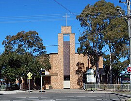
Frank Cefai laying the first stone at St Simon Stock Catholic Church.
In the early years of British settlement the area was known as Prospect Hill and was the site of the first land grants to emancipated convicts in 1791. From 1800 to 1840, the division of Darug lands into 'Crown Land Grants' was awarded to officials, military, free settlers and emancipists to farm.[3] In this period, it was one of several areas of conflict between the Darug people and the settlers, the Darug people being led for many years of guerrilla warfare by Pemulwuy.[3]
Greystanes began as a rural suburb in the 1850s and remained so until the 1880s.[3] The suburb was occupied mainly by large estates designed as rural retreats for gentlemen farmers, including Charles Whalan and Nelson Lawson. The area became differentiated into Prospect to the west of Greystanes Creek, and Greystanes to the east of the Creek.
The name 'Grey Stanes', given by Nelson Lawson, came from the outcrops of basalt on Prospect Hill, "Grey" being its colour and "Stanes" being the Scottish word for stones. The land was originally granted to William Cummings in 1799, before being acquired by the famed Blue Mountains explorer William Lawson in approximately 1810.[4]
The original residence in Grey Stanes, NSW
In 1836, ‘Greystanes House’ was built by Nelson Simmons Lawson, on land given to him by his father, on the eastern side of Prospect Hill.[5] In 1942, Greystanes House was resumed for military use for World War 2. The building was demolished in 1946, but its gates still remain intact on Greystanes Road.[6]
In 1880, the Upper Nepean Scheme commenced to provide Sydney with a reliable water supply. Vast areas of land were resumed for the project including William Lawson's estate. The army of labourers involved in the construction phases camped in a virtual ‘tent city’ at near Hyland Road.[7] The Prospect and Potts Hill Reservoirs, Boothtown Aqueduct and Lower Prospect Canal Reserve were completed in 1888.[7]
Greystanes was officially recognised as a suburb in 1922.[3]
The Greystanes area was used for poultry farming throughout the twentieth century. Frank Cefai, a Maltese migrant, was a well known developer who built hundreds of residential homes and infrastructure throughout Greystanes and its surrounding suburbs.[8] In 1973, Frank was the main contribution to the record year of development applications at Holroyd Council for Greystanes and its surrounding suburbs.[9]
In the early 1950s, the Maltese community, in particular Father Camilleri, raised donations to help Wenthworthville parish purchase the land from a poultry farmer, upon the highest hill of Greystanes to build a new Catholic church, school and parish.[10] Frank Cefai began the construction of St Simon Stock Catholic Church. Dams were filled in and poultry sheds were knocked down. The original St Simon Stock Catholic Church is located where the current science block of St Paul's Catholic High School is. This church was also used as the classrooms for the St Simon Stock Primary and High School.[11]
The St Simon Stock primary school was completed in 1958 and its all boys high school in 1962. As well as parish buildings and a nuns convent. Frank Cefai built and helped fund the Our Lady Queen of Peace Catholic Church and these surrounding primary and secondary schools and parish buildings. In 1975, Frank Cefai completed the construction of Our Lady Queen of Peace church.[12][13]
From 1957 to 1965, the Parish was cared for by the Maltese Carmelite Fathers and Our Lady Queen of Peace Primary School was run by the Sisters of Mercy. From 1965 to 1988, The Dominican Sisters of Malta ran OLQP Primary School. Their Dominican Order coat of arms forms the OLQP logo.[14] The Blessed Imelda Convent at OLQP Primary School was closed in 1988 and moved to St. Dominic Hostel, in Blacktown, Sydney (which was built by Frank Cefai); leaving OLQP a fully staffed lay school.[15]
Pan Pacific Scout Jamboree (1952-53)
An original Commemorative Pan-Pacific Scout Jamboree postage stamp from 1952
Between 29 December 1952 and 9 January 1953, more than 11,000 scouts converged on Greystanes to attend the Pan Pacific Scout Jamboree.[16] Attendees came from all Australian states plus 16 other countries, including New Zealand, United Kingdom, Papua New Guinea, Hong Kong, Iceland, Malaya, Singapore, Ceylon, Philippines, Fiji, Nauru and Malta; to participate in a full camp program.[17]
The Greystanes area was dubbed “Little Malta” by the Sydney Sun newspaper due to the influx of Maltese migrants since the 1910s who had settled in the area and taken up poultry farming or market gardening. By 1932, 30% of the produce sold at the Sydney fruit and vegetable markets was supplied by Maltese market gardeners.[18] Gozo Road, Greystanes is named after Gozo – the second largest Island in Malta.
Baiada Chickens, Cordina Farms and Pace Farm Eggs; were founded and operated by local members of the Greystanes Maltese community.[18][19]
Former Maltese corner shop in front of OLQP Catholic Church, corner of Ettalong Rd & Old Prospect Rd
The Maltese Club, previously owned by the Catholic Church, was located on the current site of Genista Aged Care Facility at 185 Old Prospect Road. The former corner shop across the road from the Catholic church, was one of many Maltese stores in the area, which sold pastizzi, kinnie and ravioli. There was also The Maltese Herald newspaper, founded by Nicholas Bonello, Vincent Pisani and Lawrence Dimech in 1961.[20] The Maltese Herald ran for fifty-two years with its final edition in 2013.[21]
Greystanes still has a large Maltese Australian community. The Maltese began a strong culture of Christmas lights and nativity sets in Greystanes. There are still displays annually, every December throughout Greystanes.[22]
Our Lady of Victories on display for the Maltese Festa, in Our Lady Queen of Peace Church, Greystanes
In 1965, the fourth centenary of the Great Siege of Malta, the statue of Our Lady of Victories (il-Bambina - a patron saint of Malta) arrived in Greystanes to the great joy of the Maltese; not only from the immediate area, but also from many other parts of Sydney. She is the centrepiece of the Greystanes Catholic Community and Our Lady Queen of Peace church, and is the centrepiece of the annual Maltese Festa procession.[23] She is a hand crafted statue from Bolzano, Italy; a replica of il-Bambina from Gozo, commissioned and funded by the Greystanes Maltese Community. Il-Vitorja or Victory Day, is a Maltese public holiday that commemorates the end of the great siege of Malta in 1565 and the end of World War II. It also coincides with the commemoration of the birth of the Virgin Mary (il-Bambina). Hereby giving the traditional name to this statue (Our Lady Queen of Victories) and festival (Festa tal-Vitorja).[24]
The first procession in honour of Our Lady in the parish was held in 1962, under the title of Our Lady of Lourdes.[23] However, since the arrival of the statue, the Maltese community have celebrated an annual Festa (il-Vitorja & il-Bambina) every October since 1965, in and around the Catholic Church (as every village in Malta traditionally does).[25][26]
Our Lady Queen of Peace church and parish was intended to be named and dedicated to Our Lady of Victories, in honour of the aforementioned statue.[27][28] However, despite hundreds of years of tradition surrounding this statue, the clergy of the Roman Catholic Diocese of Parramatta deemed it incorrect to have the moniker Victories attached to Our Lady. The church and parish were to be known as Our Lady Queen of Peace, when Frank Cefai finished construction in 1975. The statue of Our Lady of Victories is on display inside Our Lady Queen of Peace Catholic Church. She is carried by hand, traditionally, at the annual procession of the OLQP Maltese Festa.[29] The statue is accompanied by the Maltese Concert Band of NSW, who also perform the ongoing celebrations.[30]
A pioneer to the Maltese community in Greystanes,[29] the longest serving member and president of the Greystanes Maltese festa, continuously for over 50 years, is Joe Spiteri. Having joined in 1966.[31][32]
A scripted Maltese-Australian horror drama series called Greystanes,[33] was released via 18 short story episodes exclusively on TikTok, in 2024. A recipient of Screen Australia, NZ On Air and TikTok's Every Voice initiative, the series adapts Malta's Ħaddiela stories. The Greystanes series is directed by AACTA nominated filmmaker Ryan Cauchi and co-written by Matt Ferro (The Matrix, Happy Feet).[34][35]
Heritage listings
Greystanes has a number of heritage-listed sites,[36] which include:
Former farm, Widemere post office and inn at Gipps Road and Hyland Road Regional Parklands - built before 1897. The only farm group left in the area, demonstrating the former dairying industry in Greystanes. It was socially significant for its former functions within the local community, as a post office and inn.
Late Victorian suburban cottage with only minor external modifications, located at 15 Bayfield Road
The original gates to Greystanes House, located on Greystanes Road.
Remnant Tree Stands at Damien Avenue (Gallard Reserve Woodland) - one of the six indigenous forest communities in Sydney, this is a small collection of plants and shrubs, mostly Forest Red Gum (E. teraticornis) and Grey Box (E. Moluccana). It has been preserved from regular mowing and urban development for its purpose as an ecological resource to the local wildlife, as well as to preserve a rare endangered ecological community. Currently, less than 6% of the Woodlands remain in small parts distributed across the western suburbs of Sydney. Greystanes has been significantly altered since European colonisation, resulting in the loss of the large majority of this natural habitat. The Gallard Reserve Woodland is an extant, tangible reminder of the former landscape.
Notable residents
Some of the current and former notable residents of Greystanes include:
Greystanes Shopping Centre is a semi-enclosed, single level shopping centre anchored by Woolworths, along with numerous speciality shops and service providers. Greystanes Shopping Centre was refurbished in 2014.[70]
Education
Greystanes is serviced by a number of educational institutions. The Department of Education schools are:
Greystanes Public School (known as The Harper Street School, opened in 1902)
St Pauls Catholic College (1962) (originally St. Simon Stock High School and later Newman High School).
Parks and recreation
Boothtown Aqueduct off Macquarie Rd
Greystanes contains a large number of parks, ovals, and sporting facilities, as well as the famous Cumberland golf course (officially established in 1938).[71]
The south side of Greystanes features the Lower Prospect Canal Reserve what is simply known by residents as the Canal. This reserve is connected to Grey Box Reserve. Many Small neighbourhood parks are scattered around the suburb.
One prominent park is the Canal Road Park, which is 70 metres above sea level and thus features a panoramic lookout of southwest Sydney. Originally it was a water canal once used to transport water from the Prospect Reservoir, but has since been decommissioned and converted into a cycle and walkway.[72] Despite this, it is still referred to by its original function. The Canal features the regionally well-known Boothtown Aqueduct (as its original function was) located on Macquarie Rd, Greystanes.
The south-west of Greystanes contains the Gipps Road Sporting Complex and the Rosford Street Reserve, which consist of multiple ovals suitable for sports such as football and cricket. Around the ovals are large, open fields, suitable for other forms of recreation and a small BMX track in Rosford Street Reserve. The Holroyd Rifle Range and Pigeon Club[73] is located on Hyland Road, near the aforementioned sporting complexes and the Hyland Road Youth Centre and Men's Shed.
Demographics
According to the 2021 census, there were 23,511 residents of Greystanes. Of these:
49.4% were male and 50.6% were female
The median age was 39 years. Children aged 0–14 years made up 21% of the population and people aged 65 years and over made up 18.9% of the population.
62.9% of people were born in Australia. The most common countries of birth were Lebanon 4.5%, India 2.9%, Malta 2.5%, China 1.5% and Philippines 1.3%.
The most common ancestries were Australian 21%, English 16.4%, Lebanese 15.5%, Maltese 6.2% and Italian 6.1%.
55.4% of people only spoke English at home. Other languages spoken at home included Arabic 13%, Maltese 2.3%, Greek 2.1%, Turkish 1.7% and Croatian 1.6%.
The most common responses for religion were Catholic 44.7%, No Religion 13%, Islam 8.3%, Anglican 7.4%, and Eastern Orthodox 5.8%.[74]
Politics
Greystanes political information at a federal, state and local council level as of 2024. [75][76][77][78]
T- Way, Gt Western Hwy, Old Prospect Rd, Pemulwuy MarketPlace
Full week operation from 18 Apr 2021.
811X
Parramatta Stn to Pemulwuy Marketplace
T- Way, Gt Western Hwy, Old Prospect Rd, Bathurst St
Full week operation from 18 Apr 2021.
818
Westmead to Merrylands Stn
Westmead Hospitals, Wentworthville, Old Prospect Rd, Ringrose Ave
Operates on weekdays
Related Research Articles
Campbelltown is a suburb located on the outskirts of the metropolitan area of Sydney, New South Wales, Australia. It is located in Greater Western Sydney 53 kilometres (33 mi) south-west of the Sydney central business district by road. Campbelltown is the administrative seat of the local government area of the City of Campbelltown. It is also acknowledged on the register of the Geographical Names Board of New South Wales as one of only four cities within the Sydney metropolitan area.
Chatswood is a suburb in the Lower North Shore of Sydney, in the state of New South Wales, Australia, 10 kilometres north of the Sydney central business district. It is the administrative centre of the local government area of the City of Willoughby.
Birkirkara is a city in the eastern region of Malta. It is the second most populous on the island, with 24,356 inhabitants as of 2020. The town consists of five autonomous parishes: Saint Helen, Saint Joseph the Worker, Our Lady of Mount Carmel, Saint Mary and San Gorg Preca. The city's motto is In hoc signo vinces, and its coat of arms is a plain red cross, surmounted by a crown.
Greater Western Sydney (GWS) is a large region of the metropolitan area of Greater Sydney, New South Wales (NSW), Australia that generally embraces the north-west, south-west, central-west, far western and the Blue Mountains sub-regions within Sydney's metropolitan area and encompasses 11 local government areas: Blacktown, Blue Mountains, Camden, Campbelltown, Cumberland, Fairfield, Hawkesbury, Liverpool, Parramatta, Penrith and Wollondilly. It includes Western Sydney, which has a number of different definitions, although the one consistently used is the region composed of ten local government authorities, most of which are members of the Western Sydney Regional Organisation of Councils (WSROC). The NSW Government's Office of Western Sydney calls the region "Greater Western Sydney".
Kingsford is a suburb in the Eastern Suburbs of Sydney, in the state of New South Wales, Australia. Kingsford is located 6 kilometres south-east of the Sydney central business district, in the local government area of the City of Randwick.
Toongabbie is a suburb of Sydney, in the state of New South Wales, Australia. One of the oldest suburbs in Sydney, Toongabbie is located approximately 30 kilometres west of the Sydney central business district and is part of the Greater Western Sydney region. Toongabbie is split between the local government areas of the City of Parramatta, the City of Blacktown and Cumberland Council. The suburb is often locally referred to as "Toonie".
Wentworthville is a suburb in Sydney, in the state of New South Wales, Australia. Wentworthville is located 27 kilometres west of the Sydney central business district and is part of the Greater Western Sydney region. Wentworthville is split between the local government areas of the City of Parramatta and the Cumberland Council. Wentworthville is colloquially known as 'Wenty'.
Forestville is a suburb of Northern Sydney, in the state of New South Wales, Australia. Forestville is 12 kilometres north of the Sydney central business district in the local government area of Northern Beaches Council. Forestville is part of the Forest District.
Prospect is a suburb of Sydney, in the state of New South Wales, Australia. Prospect is located 32 kilometres west of the Sydney central business district in the local government area of the City of Blacktown and a small part of Cumberland City Council, is part of the Greater Western Sydney region. One of the oldest suburbs in Sydney, Prospect takes its name from the prominent nearby landmark of Prospect Hill - from the top of which people could get a prospect of the surrounding countryside.
Smithfield is a suburb of Sydney, in the state of New South Wales, Australia. Smithfield is located 31 kilometres (19 mi) west of the Sydney central business district, in the local government areas of the City of Fairfield and Cumberland Council. Located in the Greater Western Sydney region, the suburb is one of the largest in Fairfield City by area.
Pendle Hill is a suburb of Sydney, in the state of New South Wales, Australia. Pendle Hill is located 29 kilometres west of the Sydney central business district, in the local government areas of Cumberland Council and City of Parramatta and is part of the Greater Western Sydney region.
Pemulwuy is a suburb in Greater Western Sydney, in the state of New South Wales, Australia. Pemulwuy is located 30 kilometres west of the Sydney central business district in the local government area of the Cumberland Council. Pemulwuy is home to the highest point between the Blue Mountains and Sydney, the summit of Prospect Hill.
Patrician Brothers' College, Fairfield is an independent Roman Catholic comprehensive single-sex secondary day school for boys, located in Fairfield, a western suburb of Sydney, New South Wales, Australia.
Cumberland High School is a co-educational comprehensive secondary school located in the north-western metropolitan Western Sydney region of New South Wales, Australia. Cumberland High School opened in January 1962. The current principal for Cumberland is Luke Fulwood, who succeeded Mechel Pikoulas in January 2023.
The Lower Prospect Canal Reserve is a heritage-listed former farm and public water supply canal and now bushy corridor and nature reserve stretching 7.7 kilometres (4.8 mi) through the heart of suburban Sydney, New South Wales, Australia. The lineal corridor stretches from Prospect Reservoir to Sydney Water Pipehead at Albert Street, Guildford with the majority of the reserve located in Greystanes, which is a suburb within the Cumberland Council area.
St Pauls Catholic College,, is an independent, fee-paying, Roman Catholic single-sex school for boys, located in Greystanes, a western suburb of Sydney, New South Wales. The college is located on Old Prospect Rd. The college caters for students in years 7-12, with over 1000 students and over 120 teachers.
Prospect Hill, or Marrong Reserve, is a heritage-listed hill in Pemulwuy and Prospect in the greater western region of Sydney, New South Wales, Australia. Situated about 30 kilometres west of central Sydney, the hill is Sydney's largest body of igneous rock and is higher than the ridges of the Cumberland Plain around it, with its present-day highest point being 117 metres high, although before its summit was quarried away it rose to a height of 131 metres above sea level.
The Church of the Nativity of Mary is a Roman Catholic baroque parish church located in Naxxar, Malta.
Cumberland Council, trading as Cumberland City Council, is a local government area located in the western suburbs of Sydney in the state of New South Wales, Australia. The Council was formed on 12 May 2016 from the merger of parts of the Cities of Auburn, Parramatta, and Holroyd.
The Grey Box Reserve, or Greystanes Grey Box Reserve, is a small nature reserve situated in the suburb of Greystanes, New South Wales in Western Sydney, Australia. A remnant bushland of the Cumberland Plain Woodland, it mainly features native vegetation. The reserve is so-named because of its abundance of Eucalyptus moluccana, reflecting the pre-European cultural landscape of the area.
↑ Julia Finn,State Member for Granville (14 September 2017). Parliamentary Debates (Hansard). Parliament of New South Wales: House of Representatives. col.16:57.
↑ "105 volumes: illustrations (chiefly coloured), portraits (chiefly coloured); 30-40 cm.", The bulletin, John Ryan Comic Collection (Specific issues)., Sydney, N.S.W: John Haynes and J.F. Archibald, 1880, ISSN0007-4039, nla.obj-68375465, archived from the original on 24 June 2024, retrieved 23 June 2024– via Trove
↑ Hugh McDermott,State Member for Prospect (15 October 2019). Parliamentary Debates (Hansard). Parliament of New South Wales: House of Representatives. col.19:37:46.
↑ Hugh McDermott,State Member for Prospect (4 August 2016). Parliamentary Debates (Hansard). Parliament of New South Wales: House of Representatives. col.16:08.
This page is based on this Wikipedia article Text is available under the CC BY-SA 4.0 license; additional terms may apply. Images, videos and audio are available under their respective licenses.