Merrylands, New South Wales

Last updated

Merrylands
Sydney,  New South Wales
Holroyd-NSW-CouncilChambers-1.jpg
Chambers of Cumberland City Council (formerly City of Holroyd Council)
Merrylands, New South Wales
Population32,472 (2021 census)
Established1855
Postcode(s) 2160
Elevation27 m (89 ft)
Location25 km (16 mi) west of Sydney CBD
LGA(s) Cumberland City Council
State electorate(s)
Federal division(s)
Suburbs around Merrylands:
Westmead Parramatta Granville
Merrylands West Merrylands Holroyd
Guildford West Guildford South Granville

Merrylands is a suburb in Western Sydney, Australia. Merrylands is located 25 kilometres west of the Sydney central business district and is in the local government area of the Cumberland City Council.

Contents

History

Merrylands was named after the former English home of Arthur Todd Holroyd (1806–1887), who acquired land in this area in 1855 and who gave his name to the adjoining suburb of Holroyd.[ citation needed ]

Commercial area

Merrylands has a commercial area around Merrylands railway station in Merrylands Road, which mainly feature art deco style of buildings constructed in the 1930s and 1940s and is ornamented by a couple of London planetrees. Stockland Merrylands is a shopping centre with supermarkets, discount department stores and specialty shops. [1]

Transport

Merrylands railway station is on the Old Main South. There is unlimited parking for commuters. It is on the bus route from Liverpool to Parramatta. Main transport corridors of Woodville Rd (Parramatta-Hume Hwy, Western Motorway M4 (Mountains to the sea). Other main roads include Coleman St (to Westmead Hospital), Hawkesview Rd (rail overbridge to Woodville Rd), Neil St (rail overbridge to Woodville Rd), Pitt St (to Parramatta), Lois St and Excelsior St (to Granville).

Churches

There are a number of churches in Merrylands, including Merrylands East Presbyterian Church, St Margaret Mary's Catholic Church, Merrylands Anglican Church, Merrylands Baptist Church, Merrylands Uniting Church, Merrylands Presbyterian Church, an Evangelical church and C3 Church Merrylands.

St Raphael's Slovenian Catholic Church

There is also a Heritage Catholic Micro-Cathedral in honour of Saint Raphael the Arch-Angel on the corner of Warwick Road and Merrylands Road, which was not only the first and only Church in Merrylands but also one of the most uniquely designed in Western Sydney being a conventional-modern-neo-Gothic design. The Church of St Raphael was conceived by Fr. Valerijan Jenko, OFM, OAM then soon to be completed and consecrated in 1973, by assistant bishop Dr. Stanislav Lenič from Ljubljana, Slovenija (previously Yugoslavia). The next building project was the church hall. Completed in 1983 the hall became the centre of lively cultural activities. [2]

Parks

Central Gardens

With an entry Merrylands Road and Paton Street along the Cumberland Highway this nature reserve has kangaroos, emus, birdlife and waterfalls around the lake. Pinnaroo (Paton Street) and Yarrabee (Merrylands Road) can be hired for the day from Cumberland Council for a fee. Access is by road or bus from Merrylands Station and is a route of the Liverpool to the Parramatta Transitway.

Ted Burge Reserve

Bounded by Centenary Road, Hollywood, Richmond and Fairmount Streets. Is used as a sporting field for cricket, soccer, softball and netball.

Merrylands Park

Merrylands Swimming Pool MerrylandsNSWpool.jpg
Merrylands Swimming Pool

On the corner of Merrylands Road and Burnett Street this complex has sporting fields, tennis courts, barbecue areas and a swim centre which has several outdoor pools and a grassed areas with a barbecue.

Merrylands Swimming Centre

Merrylands Swimming Centre was opened in 1968 and is owned and operated by Cumberland Council. The Swimming Centre was heated in 2004 and consists of 3 pools. An 8 lane 50m competition pool, a training pool and a babies pool. The water in the competition and training pools is heated to 27 °C. [3] The centre is the home of the Merrylands Amateur Swimming Club – the second largest swimming club in the City of Cumberland and one of the largest in the South West of the Sydney Metropolitan Area. [4]

Granville Park

Bounded by Merrylands Road (east of the railway line), Claremont Street, Montrose Avenue and Woodville Road the park is approximately 13.2ha in area. McDonald's has a restaurant on the corner of the park with access from Merrylands Road and Woodville Road. It has several sporting fields, a barbecue area, basketball court, cricket and nets, and playground equipment. When the circuses arrive they stay here.

During WWII Granville Park was used as US Naval Base Hospital No 10, part of Naval Base Sydney.

Cycleways

Several main cycle routes pass through Merrylands and surrounding suburbs and linking up to Liverpool, Penrith and Sydney Harbour. M4 has an exit in Crown Street, Parramatta for Parrmatta, Merrylands and Holroyd access.

Climate

Merrylands has a temperate climate, with hot summers and mild winters. The average summer maximum temperature is 27.9 °C, but hot north-westerly winds can cause temperatures to rise to +40 °C. The highest temperature recorded in the Merrylands area was 47.0 °C on 4 January 2020. The average winter maximum temperature is 18.1 °C, however, +27 °C days have occurred, mostly in August. The coldest temperature recorded was −1.0 °C on 12 July 2002. The average yearly rainfall is 830.5mm. [5]

Demographics

According to the 2021 census of population, there were 32,472 people in Merrylands.

Notable People

Some of the current and former residents of Merrylands include:

Related Research Articles

<span class="mw-page-title-main">Liverpool, New South Wales</span> Suburb of City of Liverpool, New South Wales, Australia

Liverpool is a suburb of South Western Sydney, in the state of New South Wales, Australia. It is located approximately 31 kilometres (19 mi) south-west of the Sydney CBD. Liverpool is the administrative seat of the local government area of the City of Liverpool and is situated in the Cumberland Plain.

<span class="mw-page-title-main">Carlingford, New South Wales</span> Suburb of Sydney, New South Wales, Australia

Carlingford is a suburb of Sydney, in the state of New South Wales, Australia. Carlingford is 22 kilometres north-west of the Sydney central business district in the local government area of City of Parramatta. Carlingford sits at the meeting point of Northern Sydney and Western Sydney sitting on both sides of Pennant Hills Road which generally acts as a divider of the two regions. While being part of City of Parramatta, it is sometimes referred to as being part of the Hills District.

<span class="mw-page-title-main">Greater Western Sydney</span> Region of the metropolitan area of Sydney, Australia

Greater Western Sydney (GWS) is a large region of the metropolitan area of Greater Sydney, New South Wales (NSW), Australia that generally embraces the north-west, south-west, central-west, far western and the Blue Mountains sub-regions within Sydney's metropolitan area and encompasses 13 local government areas: Blacktown, Blue Mountains, Camden, Campbelltown, Canterbury-Bankstown, Cumberland, Fairfield, Hawkesbury, Hills Shire, Liverpool, Parramatta, Penrith and Wollondilly. It includes Western Sydney, which has a number of different definitions, although the one consistently used is the region composed of ten local government authorities, most of which are members of the Western Sydney Regional Organisation of Councils (WSROC). Penrith, Hills Shire & Canterbury-Bankstown are not WSROC members. The NSW Government's Office of Western Sydney calls the region "Greater Western Sydney".

<span class="mw-page-title-main">Cumberland Highway</span> Highway in Sydney, New South Wales, Australia

Cumberland Highway is a 34-kilometre (21 mi) long urban highway located in Sydney, New South Wales, Australia. The highway links Pacific Highway and Pacific Motorway (M1) at Pearces Corner, Wahroonga in the northeast with Hume Highway at Liverpool in the southwest. This name covers a few consecutive roads and is widely known to most drivers, but the entire allocation is also known – and signposted – by the names of its constituent parts: Pennant Hills Road, James Ruse Drive, Briens Road, Old Windsor Road, Hart Drive, Freame Street, Emert Street, Jersey Road, Betts Road, Warren Road, Smithfield Road, Palmerston Road, (New) Cambridge Street, Joseph Street and Orange Grove Road. The entire length of Cumberland Highway is designated part of route A28.

<span class="mw-page-title-main">Wentworthville, New South Wales</span> Suburb of Sydney, New South Wales, Australia

Wentworthville is a suburb in Sydney, in the state of New South Wales, Australia. Wentworthville is located 27 kilometres west of the Sydney central business district and is part of the Greater Western Sydney region. Wentworthville is split between the local government areas of the City of Parramatta and the Cumberland Council. Wentworthville is colloquially known as 'Wenty'.

<span class="mw-page-title-main">City of Holroyd</span> Former local government area in New South Wales, Australia

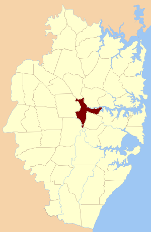
The City of Holroyd was a local government area in the western suburbs of Sydney, in the state of New South Wales, Australia. First proclaimed in July 1872 as the "Municipal District of Prospect and Sherwood", it became the "Municipality of Prospect and Sherwood" from 1906 and in 1927 it was renamed the "Municipality of Holroyd" after Arthur Holroyd, the first mayor. From 1 January 1991, city status was granted, becoming the Holroyd City Council. The administrative centre of the City was located in the suburb of Merrylands, located approximately 25 kilometres (16 mi) west of the Sydney central business district.

<span class="mw-page-title-main">Holroyd, New South Wales</span> Suburb of Sydney, New South Wales, Australia

Holroyd is a small suburb in western Sydney, New South Wales, Australia. Holroyd is located 20 kilometres (12 mi) west of the Sydney central business district in the local government area of the Cumberland Council. The previous local government area of Holroyd City took its name from Arthur Holroyd, first Mayor of the area, local landowner and businessman. The administrative centre is located in nearby Merrylands.

<span class="mw-page-title-main">City of Parramatta</span> Local government area in New South Wales, Australia

The City of Parramatta, also known as Parramatta Council, is a local government area located to the west and north-west of Sydney CBD in the Greater Western Sydney region. Parramatta Council is situated between the City of Ryde and Cumberland, where the Cumberland Plain meets the Hornsby Plateau, approximately 25 kilometres (16 mi) west of the Sydney central business district, in New South Wales, Australia. The city occupies an area of 84 square kilometres (32 sq mi) spanning across suburbs in Greater Western Sydney including the Hills District, and a small section of Northern Sydney to the far north east of its area. According to the 2016 census, City of Parramatta had an estimated population of 226,149. The city houses the Parramatta central business district which is one of the key suburban employment destinations for the region of Greater Western Sydney.

<span class="mw-page-title-main">Smithfield, New South Wales</span> Suburb of Sydney, New South Wales, Australia

Smithfield is a suburb of Sydney, in the state of New South Wales, Australia. Smithfield is located 31 kilometres (19 mi) west of the Sydney central business district, in the local government areas of the City of Fairfield and Cumberland Council. Located in the Greater Western Sydney region, the suburb is one of the largest in Fairfield City by area.

<span class="mw-page-title-main">Merrylands West, New South Wales</span> Suburb of Sydney, New South Wales, Australia

Merrylands West is a suburb in western Sydney, New South Wales, Australia.

<span class="mw-page-title-main">Lidcombe</span> Suburb of Sydney, New South Wales, Australia

Lidcombe is a suburb in western Sydney, in the state of New South Wales, Australia. Lidcombe is located 15 km (9.32 mi) west of the Sydney central business district, in the local government area of Cumberland Council, with a small industrial part in the north in the City of Parramatta. Post code: 2141, sharing it with Berala.

<span class="mw-page-title-main">Greystanes, New South Wales</span> Suburb of Greater Western Sydney, New South Wales, Australia

Greystanes is a suburb in Greater Western Sydney, New South Wales, Australia. Greystanes is located 25 kilometres west of the Sydney central business district in the local government area of Cumberland Council. Founded in the late 1790s, Greystanes is one of the oldest suburbs in Sydney.

<span class="mw-page-title-main">Guildford, New South Wales</span> Suburb of Sydney, New South Wales, Australia

Guildford is a suburb of Sydney, in the state of New South Wales, Australia. Guildford is located 27 kilometres west of the Sydney central business district, in the local government area of Cumberland City Council. Guildford is part of the Western Sydney region. Guildford is the home of the first KFC in Australia.

<span class="mw-page-title-main">Pemulwuy, New South Wales</span> Suburb of Greater Western Sydney, New South Wales, Australia

Pemulwuy is a suburb in Greater Western Sydney, in the state of New South Wales, Australia. Pemulwuy is located 30 kilometres west of the Sydney central business district in the local government area of the Cumberland Council. Pemulwuy is home to the highest point between the Blue Mountains and Sydney, the summit of Prospect Hill.

<span class="mw-page-title-main">Parish of St John</span> Cadastral in New South Wales, Australia

St John Parish is one of the 57 parishes of Cumberland County, New South Wales, a cadastral unit for use on land titles. It is named after St John's Cathedral in Parramatta, New South Wales which opened in 1803, on which the civil parish is roughly centred. The parish is shaped like a "T", with the northern part stretching from Toongabbie to the western shore of Homebush Bay. The southern end is at Prospect Creek near Yennora. Woodville Road and Parramatta Road form the boundaries to the south-east. The Old Prospect Road is part of the boundary in the west.

<span class="mw-page-title-main">Arthur Holroyd</span> Australian lawyer and politician

Arthur Todd Holroyd was an Australian lawyer and politician. He was a member of the New South Wales Legislative Council between 1851 and 1856. He was also a member of the New South Wales Legislative Assembly for two periods between 1856 and 1857 and again between 1861 and 1864.

<span class="mw-page-title-main">Central Gardens Nature Reserve</span>

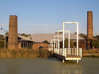
The Central Gardens Nature Reserve, also called Central Gardens, is a protected nature reserve located in the western suburbs of Sydney, New South Wales, Australia. Established in 1976, the 12-hectare (30-acre) reserve, garden and fauna and wildlife park is situated in the suburb of Merrylands and is managed by Cumberland Council. The park is regionally important and it attracts visitors outside the Cumberland local government area. The bushland contains remnants of Cumberland Plain Woodland and is approximately 3.5 hectares.

<i>The Broadcaster</i>

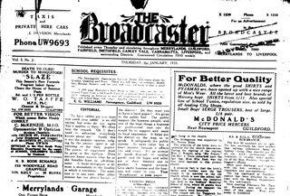
The Broadcaster was an English language local community tabloid newspaper published by several owners in Western Sydney, New South Wales, Australia that principally covered the Municipality of Holroyd and surrounding districts. It was first published in Guildford in 1932, but became a title of The Biz newspaper publishing company located in Fairfield, in 1935. The Broadcaster eventually came under the control of Cumberland Newspapers in 1958 and was retitled the Merrylands Broadcaster from April 1975. The newspaper ceased publication around 1978.

<span class="mw-page-title-main">Cumberland City Council</span> Local government area in New South Wales, Australia

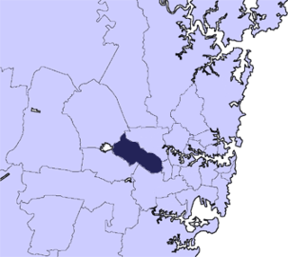
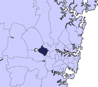
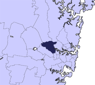
Cumberland Council, trading as Cumberland City Council, is a local government area located in the western suburbs of Sydney in the state of New South Wales, Australia. The Council was formed on 12 May 2016 from the merger of parts of the Cities of Auburn, Parramatta, and Holroyd.

The M4 cycleway is a 15-kilometre-long (9.3 mi) shared use path for cyclists and pedestrians that is generally aligned with the M4 Motorway in Sydney, New South Wales, Australia. The eastern terminus of the cycleway is in Sydney Olympic Park, while the western terminus is in South Wentworthville.

References

  1. Stockland Merrylands Mall
  2. neuropolitan. "Slovenian Community". thezaurus.com. Retrieved 26 May 2017.
  3. "Merrylands Swimming Centre". Merrylands Amateur Swimming Club. Retrieved 8 August 2014.
  4. "Swimming NSW Annual Report 2013/2014" (PDF). Swimming NSW. Retrieved 8 August 2014.
  5. http://www.bom.gov.au/jsp/ncc/cdio/weatherData/av?p_nccObsCode=139&p_display_type=dataFile&p_stn_num=067017 [ bare URL ]
  6. "2021 Merrylands, Census All persons QuickStats | Australian Bureau of Statistics". abs.gov.au. Retrieved 20 April 2023.

33°50′15″S150°59′30″E / 33.83750°S 150.99167°E / -33.83750; 150.99167