
The Harvard Bridge is a steel haunched girder bridge carrying Massachusetts Avenue over the Charles River and connecting Back Bay, Boston with Cambridge, Massachusetts. It is the longest bridge over the Charles River at 2,164.8 feet.

Transportation in Philadelphia involves the various modes of transport within the city and its required infrastructure. In addition to facilitating intracity travel, Philadelphia's transportation system connects Philadelphia to towns of its metropolitan area and surrounding areas within the Northeast megalopolis.
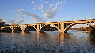
The Francis Scott Key Bridge, more commonly known as the Key Bridge, is a six-lane reinforced concrete arch bridge conveying U.S. Route 29 (US 29) traffic across the Potomac River between the Rosslyn neighborhood of Arlington County, Virginia, and the Georgetown neighborhood of Washington, D.C. Completed in 1923, it is Washington's oldest surviving road bridge across the Potomac River.

The Schuylkill Expressway, locally known as "the Schuylkill", is a freeway through southern Montgomery County and the city of Philadelphia. It is the easternmost segment of Interstate 76 (I-76) in the U.S. state of Pennsylvania. It extends from the Valley Forge interchange of the Pennsylvania Turnpike in King of Prussia, paralleling its namesake Schuylkill River for most of the route, southeast to the Walt Whitman Bridge over the Delaware River in South Philadelphia. It serves as the primary corridor into Philadelphia from points west. Maintenance and planning for most of the highway are administered through Pennsylvania Department of Transportation (PennDOT) District 6, with the Delaware River Port Authority (DRPA) maintaining the approach to the Walt Whitman Bridge.

Pennsylvania Route 3 is a 24.3-mile (39.1 km) state highway located in the southeastern portion of Pennsylvania. The route runs from U.S. Route 322 Business in West Chester east to PA 611 in Philadelphia.

The Schuylkill River Trail is a multi-use trail along the banks of the Schuylkill River in southeastern Pennsylvania. Partially complete as of 2018, the trail is ultimately planned to run about 140 miles (230 km) from the river's headwaters in Schuylkill County to Fort Mifflin in Philadelphia.

The Chestnut Street Bridge is a bridge across the Schuylkill River that carries Chestnut Street in Philadelphia, Pennsylvania. The original 1861 bridge was "a bridge whose scale and use of cast iron made it singular in the United States and throughout the world". The 1957 bridge, now one way, helps connect West Philadelphia with the rest of the city.
Walnut Street is located in Center City Philadelphia and extends to the Delaware River waterfront and West Philadelphia. Walnut Street has been characterized as "the city's premier shopping district" by The Philadelphia Inquirer.
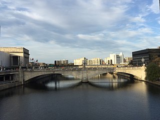
The Market Street Bridge carries Market Street, the primary east-west street in Philadelphia, Pennsylvania, across the Schuylkill River. The current bridge is the fifth permanent structure built at the site.
Mill Creek rises in Montgomery County, Pennsylvania; runs southeasterly to West Philadelphia, where it enters 19th-century sewer pipes; and debouches roughly five miles later in the Schuylkill River near The Woodlands Cemetery. It starts near Narberth, where its source is buried, then runs free for a mile or so before entering Philadelphia at the Overbrook station.

The Walnut Lane Bridge is a concrete arch bridge located in Northwest Philadelphia that connects the Germantown and Roxborough neighborhoods across the Wissahickon Creek in Fairmount Park. While drivers may cross the bridge too quickly to notice, the view from underneath the bridge has inspired many artists and writers, such as Christopher Morley. The design was copied from Pont Adolphe in Luxembourg.

The Mont Clare Bridge is a crossing of the Schuylkill River between Mont Clare and Phoenixville in Pennsylvania, USA. The bridge was also referred to as the Intercounty Bridge, as it connects Montgomery and Chester counties. The bridge abuts a shorter county bridge across the Schuylkill Canal and towpath on the Mont Clare side to complete the crossing. The crossing carries Bridge Street and the Schuylkill River Trail.

The Falls Bridge is a steel Pratt truss bridge that spans the Schuylkill River in Fairmount Park in Philadelphia, Pennsylvania. It connects Kelly Drive at Calumet Street with Martin Luther King, Jr. Drive at Neill Drive. It replaced a wooden covered bridge at the same site.

The Wilmington Rail Viaduct is a series of fills and bridges, about 4 miles (6.4 km) long, that carries the Northeast Corridor through the city of Wilmington, Delaware, above street level. Constructed between 1902 and 1908, the structure consists principally of fills supported by heavy stone retaining walls, punctuated with plate girder bridges over streets, and augmented by a few sections of brick arch viaduct. Its construction is typical of the Pennsylvania Railroad's architectural practices at the time, and the viaduct has been documented by the Historic American Engineering Record and listed on the National Register of Historic Places. Built by the Pennsylvania Railroad (PRR) as part of a series of grade crossing eliminations along the Northeast Corridor, the elevation of the rail line necessitated several other changes to rail infrastructure in Wilmington, including the construction of the Wilmington Shops at the east end of the viaduct, and the construction of the Wilmington Station and adjacent Pennsylvania Railroad Office Building along the elevated right-of-way.

Gray's Ferry Bridge has been the formal or informal name of several floating bridges and four permanent ones that have carried highway and rail traffic over the Schuylkill River in Philadelphia. The bridge today is a four-lane divided highway bridge, built in 1976, that carries Grays Ferry Avenue from the Grays Ferry neighborhood on the east bank, over the river and the Northeast Corridor railroad tracks, to the Southwest Philadelphia neighborhood of Kingsessing.

Pennsylvania Railroad, Connecting Railway Bridge is a stone arch bridge in Philadelphia, Pennsylvania, that carries Amtrak Northeast Corridor rail lines and SEPTA and NJT commuter rail lines over the Schuylkill River. It is located in Fairmount Park, just upstream from the Girard Avenue Bridge.

The East River Greenway is an approximately 9.44-mile-long (15.19 km) foreshoreway for walking or cycling on the east side of the island of Manhattan on the East River. It is part of the Manhattan Waterfront Greenway. The largest portions are operated by the New York City Department of Parks and Recreation. It is separated from motor traffic, and many sections also separate pedestrians from cyclists. The greenway is parallel to the Franklin D. Roosevelt East River Drive for a majority of its length.
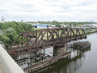
Philadelphia, Wilmington and Baltimore Railroad Bridge No. 1 was a swing steel through truss that spanned the Schuylkill River between Philadelphia, Pennsylvania's Kingsessing and Grays Ferry neighborhoods.

The Margaret McDermott Bridge is a conventional concrete pier-and-beam freeway bridge with cable-stayed bike lines over the Trinity River in Dallas, Texas. It replaced the late-1950s to early-1960s Interstate 30 (I-30) bridge, which reached its end of life. It was partially designed by Santiago Calatrava, and is part of the Trinity River Project and the Horseshoe Project. It was named for Margaret McDermott, an area philanthropist.

The Penn Street Bridge, also known as the Penn Street Viaduct, is a historic bridge crossing the Schuylkill River into Reading, Pennsylvania, the largest city in Berks County and fourth-largest city in the state. The bridge is considered to be the primary gateway to downtown Reading, leading directly onto Penn Street, the main thoroughfare of the city. The opposite end of the bridge leads into the borough of West Reading and connects with an interchange onto the West Shore Bypass section of U.S. Route 422. As a result of the bridge's prominent location, it has an average daily traffic volume of nearly 34,000. Constructed in 1913, the bridge is one of the oldest examples in the region of an open-spandrel concrete arch bridge, and it retains good historic integrity including original ornate concrete railings; it was determined eligible for listing in the National Register of Historic Places in 2007 and reevaluated in 2019.


