
Cahir is a town in County Tipperary in Ireland. It is also a civil parish in the barony of Iffa and Offa West.

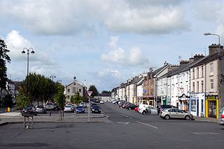
Nenagh meaning “The Fair of Ormond” or simply "The Fair", is the county town and second largest town in County Tipperary in Ireland. Nenagh used to be a market town, and the site of the East Munster Ormond Fair.
The N8 road is a national primary road in Ireland, connecting Cork with Dublin via the M7. The N8 is further classified by the United Nations as the entirety of the European route E 201, part of the trans-Europe International E-road network. The road is motorway standard from junction 19 on the M7 to the Dunkettle interchange in Cork City and is designated as the M8 motorway. From here the route continues into City city centre and terminates at the N22 road at St. Patrick's Street. The M8 motorway was completed in May 2010, replacing the single carriageway sections of the old N8 and bypassing towns on the main Cork to Dublin road. It is now possible to travel from Cork to Dublin on the M/N8 in about 2 hours 30 minutes. The route commences just south of Portlaoise, and reaches Cork via the midlands and the Golden Vale of Ireland, through Counties Laois, Kilkenny, Tipperary, Limerick and Cork.
Templemore is a town in County Tipperary, Ireland. It is a civil parish in the historical barony of Eliogarty. It is part of the parish of Templemore, Clonmore and Killea in the Roman Catholic Archdiocese of Cashel and Emly.

Roscrea is a market town in County Tipperary, Ireland, which in 2016 had a population of 5,446. Roscrea is one of the oldest towns in Ireland, having developed around the 7th century monastery of Saint Crónán of Roscrea, parts of which remain preserved today.

Borrisokane is a town in County Tipperary, Ireland. It is situated at the junction of the N52 and N65 national secondary roads. At the 2016 census, it had a population of 942. The Ballyfinboy River flows through the town on its way to Lough Derg, 12 km (7 mi) to the west. It is also a civil parish in the historical barony of Ormond Lower and an Ecclesiastical parish in the Roman Catholic Diocese of Killaloe.

Horse and Jockey is a village in County Tipperary, Ireland. It lies on the R639 road, where it meets the N62 road to Thurles. It lies just off junction 6 of the M8 motorway, which by-passed the village in December 2008. It is in the parish of Moycarkey in the barony of Eliogarty.

Ballylooby is a village in County Tipperary in Ireland. It is in the barony of Iffa and Offa West, and is also a parish in the Roman Catholic Diocese of Waterford and Lismore.

The R639 road is one of Ireland's regional roads. Once designated the N8 national primary road, it was reclassified in stages as the R639 following the progressive opening of sections of the M8 motorway, which rendered the single carriageway N8 redundant as a national primary road. By-passed sections of the old N8 were generally reclassified as R639 as soon as a new section of M8 opened, thereby increasing the length of the R639. With the completion of the M8 on 28 May 2010, the R639 now stretches from Durrow, County Laois to Cork, running through counties Laois, Kilkenny, Tipperary, Limerick and Cork.

Moneygall is a small village on the border of counties Offaly and Tipperary, in Ireland. It is situated on the R445 road between Dublin and Limerick. There were 313 people living in the village as of the 2016 census. Moneygall has a Catholic church, motorway service station, a car sales and repair centre, a national school, a Garda station and two pubs. The nearest Church of Ireland church, Borrisnafarney, is 2 km from the village beside the former Loughton Demesne.
Rathcabbin often Rathcabban is a small village and an electoral district situated at the very north of County Tipperary in Ireland. The village is located off the R489 regional road between Portumna, County Galway and Birr, County Offaly. It is 5 km east of the River Shannon and Lough Derg.

The R489 road is a regional road in Ireland linking the N52 at Riverstown, County Tipperary with the N65 east of Portumna bridge.
Modreeny is a townland and a civil parish in the historical barony of Ormond Lower, County Tipperary in Ireland situated on the R490 road between the towns of Borrisokane and Cloughjordan. Ormond Foxhounds are based at kennels at Modreeny.

Abbeville is a townland in the Barony of Ormond Lower, County Tipperary, Ireland. It is located in the Civil parish of Lorrha.

The Little Brosna River rises near Dunkerrin, County Offaly, Ireland. It flows for 36 miles before joining the River Shannon.
The Ballyfinboy River rises close to Moneygall in County Offaly, Ireland and flows in a generally northwesterly direction into Lough Derg at Drominagh. It forms part of the boundary between County Tipperary and County Offaly. The river flows through the towns of Cloughjordan and Borrisokane west of which it flows past Ballyfinboy Castle, a ruined tower house with a Sheela na gig in the townland of Ballyfinboy.
Aglish is a small settlement in County Tipperary in Ireland. It is in the Civil parish and electoral division of Aglishcloghane in the historical barony of Ormond Lower. It is located approximately 7 km north of Borrisokane, 1 km east of the R438 road.
Ballinderry is a village and a townland in the historical Barony of Ormond Lower, County Tipperary, Ireland. It is located between Terryglass and Nenagh where the R493 road crosses the Ballyfinboy River.

The Nenagh River rises in the Silvermine Mountains in County Tipperary, Ireland. It flows east of Nenagh and into Lough Derg just north of Dromineer.
Marian Tobin ran a safe house in Ireland during the Irish War of Independence and was known particularly for sheltering Dan Breen and Seán Treacy after the Soloheadbeg ambush, the incident which sparked the war.
