Related Research Articles

Toledo Bend Reservoir is a reservoir on the Sabine River between Texas and Louisiana. The lake has an area of 185,000 acres (750 km2), the largest man-made body of water partially in both Louisiana and Texas, the largest in the South, and the fifth largest by surface acre in the United States. The dam is capable of generating 92 megawatts of electrical power. The dam itself is located in the northeast corner of Newton County, Texas; however, that county includes very little of the reservoir, as most of it extends northward into parts of Sabine and DeSoto parishes in Louisiana, and Sabine, Shelby, and Panola counties in Texas.

The Coosa River is a tributary of the Alabama River in the U.S. states of Alabama and Georgia. The river is about 280 miles (450 km) long.

Lake Allatoona is a U.S. Army Corps of Engineers reservoir on the Etowah River in northwestern part of the State of Georgia. This reservoir is mostly in southeastern Bartow County and southwestern Cherokee County. A small portion is located in Cobb County near Acworth.

Lake Martin is located in Tallapoosa, Elmore and Coosa counties in Alabama. It is a 44,000-acre (178 km2) reservoir with over 750 miles (1,200 km) of wooded shoreline. Lake Martin is a reservoir, enlarged by the construction of Martin Dam on the Tallapoosa River. The Martin Dam powerhouse is used to generate hydroelectric power for the Alabama Power Company. Construction on Martin Dam began in 1923 and was completed in 1926, creating what was, at that time, the largest human-made body of water in the world. Originally known as Cherokee Bluffs for the geological formation upon which it was built, the dam was renamed in 1936 in honor of Thomas Martin, the then-president of Alabama Power Company. Alabama Power and Russell Lands own some of the shoreline.

Lake Chelan Dam officially known as the Lake Chelan Hydroelectric Project is located approximately 32 miles (51 km) north of the city of Wenatchee in Chelan County. The dam is located at the lower or southeasterly end of 50.4 miles long Lake Chelan, and is within the limits of the city of Chelan. The powerhouse is located near the community of Chelan Falls. The reservoir has 677,400 acre-feet (835,600,000 m3) of usable water storage. The 10-year average generation for the Project is 365,000 megawatt hours.

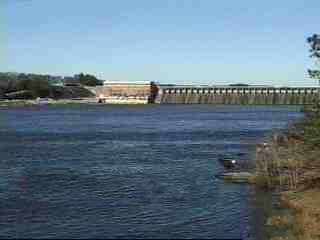
Logan Martin Lake is a reservoir located in east central Alabama on the Coosa River approximately 30 miles (48 km) east of Birmingham, Alabama. This 17,000-acre (69 km2) reservoir was built in 1965 by Alabama Power Company. The lake, nicknamed Lake of a Thousand Coves by locals, has 275 miles (443 km) of shoreline along its 48.5-mile (78.1 km) length sandwiched between Logan Martin Dam on the south and Neely Henry Dam on the north. The depth of the lake is 35 to 110 feet (34 m) with only five feet average water level variance.
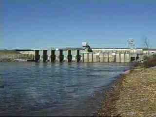
Neely Henry Lake is located on the Coosa River near Gadsden, Alabama. The lake was formed by the Neely Henry Dam, built in 1966 by Alabama Power Company for hydroelectric power and recreation.

Bankhead Lake is a reservoir along the Black Warrior River that begins in Walker County in the state of Alabama. The lake forms the border between Jefferson and Tuscaloosa County, as well as the border dividing Jefferson and Walker County. It eventually empties into Holt Lake.

Lake Qaraoun is an artificial lake or reservoir located in the southern region of the Beqaa Valley, Lebanon. It was created near Qaraoun village in 1959 by building a 61 m-high (200 ft) concrete-faced rockfill dam in the middle reaches of the Litani River. The reservoir has been used for hydropower generation, domestic water supply, and for irrigation of 27,500 ha.
Weiss Lake in northeastern Alabama is owned and operated by the Alabama Power Company. At full summer pool, Weiss Lake sits 564 feet (172 m) above sea level. The lake covers 30,200 acres (122 km2) from the Coosa River, Chattooga River (Alabama–Georgia) and Little River, offering over 447 miles (719 km) of shoreline and shallow flats, large coves, under-water drop offs and deep channels. Weiss Lake also has privately owned hotels, marinas, campground and bait and tackle stores. There are 11 bridges that cross Weiss Lake.
R.E. "Bob" Woodruff Lake is a lake on the Alabama River in central Alabama. Woodruff Lake stretches along 80 miles (130 km) of the Alabama River and has an area of about 20 square miles (52 km2).
Martin Dam is a concrete arch gravity dam on the Tallapoosa River in Alabama in the United States, about 10 miles (16 km) southwest of Dadeville. Impounding the 40,000-acre (16,000 ha) Lake Martin, the dam was built in the 1920s to provide flood control, hydroelectric power generation and water supply. Originally known as the Cherokee Bluffs dam, the dam is named in honor of Thomas Wesley Martin, president of the Alabama Power Company during the dam's construction. The African American community of Kowaliga was submerged by Lake Martin.
Winder Dam is a proposed small, low-head, earth core rockfill, hydroelectric power generation dam of 0.3 megawatt (MW) generation capacity, located across Winder River about 100 km from Karachi in Lasbela District, Balochistan province of Pakistan.
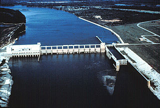
Lay Dam is a hydroelectric power dam on the Coosa River in Chilton County and Coosa County, near Clanton, Alabama.

Jordan Lake is a lake in Elmore County, Alabama. The closest city is Wetumpka.

Jocassee Dam is an embankment dam on the Keowee River, straddling the border of Pickens and Oconee counties in South Carolina in the United States. The dam forms Lake Jocassee, which is fed by the Toxaway, Thompson, Horsepasture and Whitewater Rivers, and serves primarily for hydroelectric power generation and flood control. The dam and reservoir are part of the Keowee-Toxaway Hydroelectric Project, owned and operated by Duke Energy.
Soda Dam, also known as Alexander Dam, is a dam in Caribou County, Idaho, directly west of the town of Soda Springs.
Donnells Dam is a concrete arch dam located on the Middle Fork of the Stanislaus River in Tuolumne County, California. The water impounded by the 291-foot (89 m) high dam forms Donnell Lake in Stanislaus National Forest. The dam and reservoir are co-owned by the Oakdale Irrigation District and South San Joaquin Irrigation District, and the dam is one of three in the Tri-Dam Project. The other two dams in the project are Beardsley Dam and Tulloch Dam.

The Upper North Fork Feather River Project is a hydroelectric scheme in the Sierra Nevada of California, within Lassen and Plumas Counties. The project consists of three dams, five power plants, and multiple conduits and tunnels in the headwaters of the North Fork Feather River, a major tributary of the Feather—Sacramento River systems. The total installed capacity is 362.3 megawatts (MW), producing an annual average of 1,171.9 gigawatt hours (GWh). The project is also contracted for the delivery of irrigation water between March 31 and October 31 of each year. The project is owned and operated by Pacific Gas and Electric Company.
Northfield Mountain is a pumped-storage hydroelectric plant and reservoir located on and under the similarly named Northfield Mountain in Erving and Northfield, Massachusetts. It is currently owned by FirstLight Power Resources, which purchased the facility from Northeast Utilities in 2006.
References
- ↑ "Walter Bouldin". findlakes.com. Archived from the original on 2011-08-26.
- ↑ "Walter Bouldin Dam - Alabama Power". www.alabamapower.com. Archived from the original on 2008-05-15.
- ↑ "Lake Jordan Statistics".
- ↑ "Coosa Project - Alabama Power". www.alabamapower.com. Archived from the original on 2007-05-03.
- ↑ "584 F2d 750 Alabama Power Company v. Federal Energy Regulatory Commission". 27 November 1978. p. 750.