Kalyan-Dombivli is a twin city and it comes under Mumbai Metropolitan Region and it is a municipal corporation with its headquarters located in Kalyan in Thane district in the Indian state of Maharashtra. It was formed in 1982 to administer the twin townships of Kalyan and Dombivli. Kalyan has a history of over 700 years. Kalyan is also a major Railway Junction for the trains operating in Central Railway.
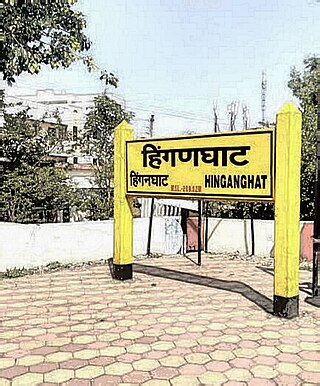
Hinganghat is a city in Wardha district of the Indian state of Maharashtra. The city is administered by a Municipal Council and is located about 35 km (22 mi) from Wardha and 72 km (45 mi) from Maharashtra's second capital Nagpur.

Nagpur district is a district in the Vidarbha region of Maharashtra state in central India. The city of Nagpur is the district administrative centre. The district is part of Nagpur Division.
Bhandara is a village and municipal council which serves the administrative headquarters of eponymous administrative Bhandara Taluka and Bhandara district in the state of Maharashtra, India. It is connected with NH-53 and NH-247.
Dhamangaon is a town and a municipal council in Amravati district in the state of Maharashtra, India. Dhamangaon is one of the three talukas in Chandur (Railway) subdivision in Amravati district. The municipal council is named as Dattapur-Dhamangaon Municipal council.
Erandol is a town and a taluka in Jalgaon district in the Indian state of Maharashtra state. It is situated on the banks of the Anjani River.

Kalameshwar-Bramhani is a city and a municipal council also a major Industrial hub in Nagpur district in the Indian state of Maharashtra. It is connected to National Highways NH-353I, NH-353J & NH-547E.
Katangi is a City and a Municipal Council, near City of Balaghat in Balaghat District in the Indian state of Madhya Pradesh.
Khapa is a city and a municipal council in Nagpur district in the Indian state of Maharashtra.
Mahadula is a census town in Nagpur district in the Indian state of Maharashtra.

Mohpa is a city with a municipal council in Nagpur district in the Indian state of Maharashtra. Although physically located within Kalmeshwar taluka, it is not subject to taluka governance. It is divided in to basically three part
Mowad is a town and a municipal council in Nagpur district of Maharashtra, India. The town is located on the Wardha River.
Narkhed is a town and a municipal council in Nagpur district in the Indian state of Maharashtra. It is about 87 km north-west of Nagpur. It is the administrative headquarters of Narkhed taluka, one of the 14 talukas of this district. It is located in the "orange belt" and is a major center for orange-trading.

Ramtek is a city and municipal council in Nagpur district of Maharashtra, India.

Sausar (Saunsar) is a Municipal Council in the central India in the state of Madhya Pradesh. Sausar lies in Vidharbha region, Nagpur is the center for all the economic activities in this region which is just 72 km from Sausar. More than 90 per cent of farmers produce oranges. Cotton is grown in large quantities in the local area.
Sinnar is a city and a municipal council in Sinnar taluka of Nashik district in the Indian state of Maharashtra. Sinnar is the third largest city in Nashik district after Nashik and Malegaon.
Parola is a city and a municipal council in Jalgaon district in the Indian state of Maharashtra. It is located on the Hajira (Surat)–Dhule–Kolkata national highway 6. The municipal council was established by the British government before the independence of India. This City is centuries old known for the two main features such as the Shree Balaji Temple and The Parola fort Also known as the native of Rani Laxmibai of Jhansi.
Wadi is a city and a municipal council in the Nagpur district of the Indian state of Maharashtra. It connected with National Highway NH-53, National Highway NH-353I, National Highway NH-353J.
Sindi is a city and a municipal council in Wardha district. Sindi is also known as Pola city. Sindi railway station is important stop between Wardha-Nagpur central rail route.
Ashta is a city and a municipal council in Sangli district in the state of Maharashtra, India. It is located at 16.95°N 74.4°E. It has an average elevation of 567 metres (1860 ft). The name "Ashta" comes from the legend that Lord Shri Ram established eight (Asht) Lord Mahadev temples in this area. The city is divided into 19 wards for which elections are held every 5 years. The Ashta Municipal Council has the population of 37,105 of which 19,171 are males while 17,934 are females as per the report released by Census India 2011.
