Jauja Province is a Peruvian province. It is one of the nine provinces of the Junín Region. To the north it borders with the Yauli, Tarma and Chanchamayo Provinces. To the east with the Satipo Province, to the south with the Concepción Province and to the west with the Lima Region. The capital of the Jauja Province is the city of Jauja. The city was founded by Francisco Pizarro as the first capital of Peru.

The Yauyos Province is a province located in the Lima Region of Peru. It is one of the eleven that make up that region.

Laraos District is one of thirty-three districts of the province Yauyos in the Lima Region in Peru.

Huantán District is one of thirty-three districts of the province Yauyos in Peru.
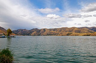
The Nor Yauyos-Cochas Landscape Reserve is a protected area in Peru located in the Lima Region, Yauyos Province and in the Junín Region, Jauja Province. It lies with the Peruvian Yungas and Central Andean wet puna ecoregions.
Chuspicocha is a lake in Peru located in the Lima Region, Yauyos Province, Tanta District. It is situated at a height of about 4,625 metres (15,174 ft), about 1.02 km long and 0.4 km at its widest point. Chuspicocha lies south of the Pariacaca mountain range and Paucarcocha and north of Ticllacocha and Piscococha, near the village of Tanta.
Ñawinpuyku is a lake in Peru located in the Lima Region, Yauyos Province, Tomas District. Ñawinpukyu is situated near the eastern border of the district, southeast of the village Kimsakancha (Quimsacancha) and northwest of the village Yanamach'ay.
Ticllacocha is a lake in Peru located in the Lima Region, Yauyos Province, Tanta District. It is situated at a height of about 4,475 metres (14,682 ft), south of the lakes Paucarcocha, Chuspicocha and Piscococha and northwest of the mountains Ticlla and Huayna Cotoni.
Lake Mullucocha is a lake in Peru located in the Lima Region, Yauyos Province, Tanta District. Mullucocha, situated at a height of about 4,286 metres (14,062 ft), lies southeast of the Pariacaca mountain range, east of P'itiqucha and northeast of Paucarcocha.

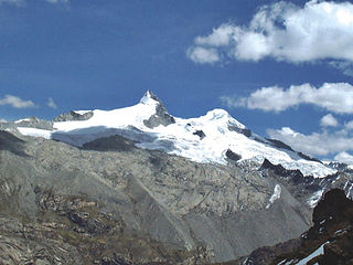
Ticlla or Qutuni, also called Tiklla or Tiqlla, is a 5,897-metre-high (19,347 ft) mountain in the Cordillera Central in the Andes of Peru. Strictly speaking the popular name Ticlla refers to a group of peaks of the Qutuni-Ticlla cirque. The highest mountain of the massif is named Qutuni. It lies in a sub-range of the Cordillera Central named Pichqa Waqra.
Challwaqucha may refer to:
Ch'uspiqucha may refer to:
Suyruqucha is a mountain in the Paryaqaqa or Waruchiri mountain range in the Andes of Peru, about 5,500 metres (18,045 ft) high. It is located in the Junín Region, Jauja Province, Canchayllo District, in the Yauli Province, Suitucancha District, and in the Lima Region, Huarochiri Province, Quinti District. It lies on the western border of the Nor Yauyos-Cochas Landscape Reserve. It is situated northwest of Qullqip'ukru. Wararayuq lies west of it.
Parya Chaka is a mountain in the south of the Paryaqaqa or Waruchiri mountain range in the Andes of Peru, about 5,000 m (16,404 ft) high. It is also the name of a lake near the mountain. The mountain is located in the Lima Region, Huarochirí Province, Quinti District, and in the Yauyos Province, Tanta District. It is situated southwest of Paryaqaqa. It is situated within the borders of the Nor Yauyos-Cochas Landscape Reserve.
Uqsha is a mountain in the Cordillera Central in the Andes of Peru, about 4,800 m (15,748 ft) high. It is located in the Lima Region, Huarochirí Province, Quinti District, and in the Yauyos Province, Tanta District, southwest of the lake named P'itiqucha. Uqsha lies northeast of Waswa Punta and southeast of Hatun Ukru. It is situated on the western border of the Nor Yauyos-Cochas Landscape Reserve.
Altarniyoc is a 5,356-metre-high (17,572 ft) mountain in the Cordillera Central in the Andes of Peru. It is located in the Lima Region, Yauyos Province, on the border of the districts of Miraflores and Tanta. Altarniyoc lies southeast of a lake named Piscococha, southwest of the peak of Uman and northeast of Huayna Cotoni and Ticlla of the Pichcahuajra mountain range.
Chakraqucha is a mountain, lying south of a small lake of the same name in the Cordillera Central in the Andes of Peru, about 4,600 m (15,100 ft) high. It is located in both the Lima Region, Huarochirí Province, Quinti District, and in the Yauyos Province, Tanta District.
Upyanqa is a mountain in the Cordillera Central in the Andes of Peru which reaches an altitude of approximately 5,300 m (17,400 ft). It is located in the Lima Region, Yauyos Province, in the districts of Colonia and Huantan, north and northeast of a lake and a mountain named Wankarqucha. Upyanqaqucha is the name of a small lake northwest of Upyanqa.
Challwaqucha is a lake in Peru located in the Lima Region, Yauyos Province, on the border of the districts of Colonia and Tupe. It lies southeast of the mountain and the lake named Wankarqucha. The Challwamayu originates south of the lake. Its waters flow to the Cañete River.
T'uru is a mountain in the Cordillera Central in the Andes of Peru which reaches an altitude of approximately 5,100 m (16,700 ft). It is situated in the Lima Region, Yauyos Province, in the districts of Colonia and Huantan. T'uru lies southeast of Upyanqa and Wankarqucha east of the lake named Wankarqucha. There is a little lake southeast of the mountain which is named Chullumpiqucha.


