The Wapous River is a tributary of the Gouin Reservoir, flowing in the territory of the town of La Tuque, in the administrative region of Mauricie, in Quebec, in Canada.

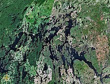
The Gouin Reservoir is a man-made lake, in La Tuque, in Mauricie, in the central portion of the Canadian provinceof Quebec, fully within the boundaries of the City of La Tuque. It is not one contiguous body of water, but the collective name for a series of connected lakes separated by innumerable bays, peninsulas, and islands with highly irregular shapes. It has therefore a relative long shoreline of over 5,600 km compared to its surface area of 1,570 km². It is the source of the Saint-Maurice River.
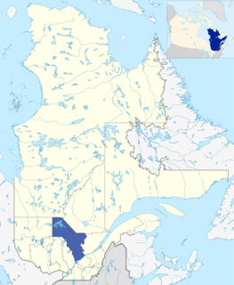
Mauricie is a traditional and current administrative region of Quebec. La Mauricie National Park is contained within the region, making it a prime tourist location. The region has a land area of 35,855.22 km² and a 2006 census population of 258,928 residents. Its largest cities are Trois-Rivières and Shawinigan.

Quebec is one of the thirteen provinces and territories of Canada. It is bordered to the west by the province of Ontario and the bodies of water James Bay and Hudson Bay; to the north by Hudson Strait and Ungava Bay; to the east by the Gulf of Saint Lawrence and the province of Newfoundland and Labrador; and to the south by the province of New Brunswick and the US states of Maine, New Hampshire, Vermont, and New York. It also shares maritime borders with Nunavut, Prince Edward Island, and Nova Scotia. Quebec is Canada's largest province by area and its second-largest administrative division; only the territory of Nunavut is larger. It is historically and politically considered to be part of Central Canada.
The Wapous River flows in the townships of Lindsay, Berlinguet, and Déziel, almost at the north-eastern limit of the territory of La Tuque and near the boundary of the administrative region of Saguenay-Lac-Saint-Jean. Forestry is the main economic activity of this valley; recreational tourism activities, second.
A forest road branch serves the upper part of this watercourse. This road branch connects with route 212 which bypasses the Gouin Reservoir by the north-east and connects the village of Obedjiwan, Quebec and La Tuque.

Obedjiwan is a First Nations reserve and village on the north shore of Gouin Reservoir in the Mauricie region of Quebec, Canada. It belongs to the Atikamekw d'Opitciwan band of the Atikamekw Nation.
The surface of the Wapous River is usually frozen from mid-November to the end of April, however, safe ice circulation is generally from early December to late March.

Maskoskanaw River is a tributary of Frontenac Lake, flowing into the unorganized territory of Lac-Ashuapmushuan, Quebec, in the Regional County Municipality (MRC) of Le Domaine-du-Roy, in the administrative region of Saguenay-Lac-Saint-Jean, in Quebec, in Canada.

The Atimokateiw River is a tributary of the south shore of the Gouin Reservoir, flowing into the territory of the town of La Tuque, in the area of Mauricie, Quebec, Canada.
The Toussaint River is a tributary of the north shore of the Gouin Reservoir, flowing in Quebec, in Canada in the administrative region of:
The Kakospictikweak River is a tributary of the North Shore of Gouin Reservoir, sinking in Quebec, Canada in the administrative region of Mauricie of:
The Pokotciminikew River is a tributary of the North Shore of the Kakospictikweak River, flowing into the territory of the Town of La Tuque, in the administrative region of Mauricie, in Quebec, in Canada. The course of this river successively crosses the cantons of Pfister, Balete and Mathieu.
The Jean-Pierre River is a tributary of the Jean-Pierre Bay, on the south shore of the Gouin Reservoir, flowing into the territory of the town of La Tuque, into the administrative region of Mauricie, in Quebec, in Canada.
The Leblanc River is a tributary of the De La Galette River, flowing on the south shore of the Gouin Reservoir, in the territory of the town of La Tuque, in the Mauricie administrative region, in Quebec, in Canada.
The De La Galette River is a tributary of the southern shore of Gouin Reservoir, flowing into the territory of the town of La Tuque, in the administrative region of the Mauricie, in Quebec, in Canada.
The Kikendatch Bay is a freshwater body that leads to the Gouin Reservoir, in the territory of La Tuque, in Haute-Mauricie, in the administrative region of Mauricie, in the province of Quebec, in Canada.
The Lake Brochu is a vast expanse of freshwater in the south-eastern part of the Gouin Reservoir, in the territory of the town of La Tuque, in the administrative region of Mauricie, in the province of Quebec, in Canada.
The Nemio River is a tributary of the south shore of the Gouin Reservoir, flowing in the town of La Tuque, in the administrative region of Mauricie, in Quebec, in Canada.
The Mistatikamekw River is a tributary of the Oskélanéo River which flows into the South Bay of Bureau Lake, flowing into the town of La Tuque, in the administrative region of Mauricie, in Quebec, in Canada.
The Flapjack River is a tributary of the Mattawa Bay of the Southwest of Gouin Reservoir, flowing into the town of La Tuque, into the administrative area of the Mauricie, in Quebec, in Canada.
The Tessier Lake is a freshwater body located on the south side of the southwestern part of the Gouin Reservoir, in the territory of the town of La Tuque, in the region of Mauricie, in the province of Quebec, in Canada.
The Faucher River is a tributary of Tessier Lake located on the southwestern side of the Gouin Reservoir. This river runs in the town of La Tuque, in the administrative region of Mauricie, in Quebec, in Canada.
Bignell Creek is a tributary of the Adolphe-Poisson Bay located on the southwestern side of the Gouin Reservoir. This stream runs entirely in forest zone in the town of La Tuque, in the administrative region of Mauricie, in Quebec, in Canada.
The Plamondon Creek is a tributary of the Plamondon Bay located in the western part of the Gouin Reservoir. This stream runs entirely in forest zone in the town of La Tuque, in the administrative region of Mauricie, in Quebec, in Canada.
The De la Rencontre Creek is a tributary of the Du Mâle Lake located in the western part of the Gouin Reservoir, flowing entirely into forest area in the town of La Tuque, in the administrative region of Mauricie, Quebec, Canada.
The Piponisiw River is a tributary of Simard Lake located in the western part of the Gouin Reservoir, flowing entirely into the forest zone in the town of La Tuque, in the administrative region of Mauricie, Quebec, Canada.
The Simard Lake is a freshwater body located in the northwestern part of Gouin Reservoir, in the territory of the town of La Tuque, in the administrative region of Mauricie, in the province of Quebec, in Canada.