| Atimokateiw | |
|---|---|
 Plan de la rivière Saint-Maurice | |
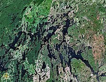 Map of Gouin Reservoir seen from space | |
| Location | |
| Country | Canada |
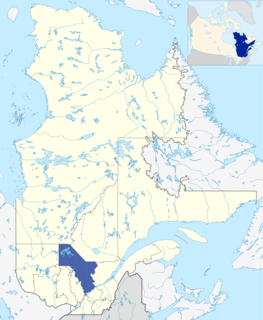
| Province | Quebec |
| Region | Mauricie |
| Physical characteristics | |
| Source | Unidentified Lake |
| ⁃ location | La Tuque, Mauricie, Quebec |
| ⁃ coordinates | 48°24′36″N74°24′20″W / 48.41000°N 74.40556°W |
| ⁃ elevation | 469 m (1,539 ft) |
| Mouth | Gouin Reservoir (Kikendatch Bay) |
⁃ location | La Tuque, Mauricie, Quebec |
⁃ coordinates | 48°22′25″N74°20′20″W / 48.37361°N 74.33889°W Coordinates: 48°22′25″N74°20′20″W / 48.37361°N 74.33889°W |
⁃ elevation | 402 m (1,319 ft) |
| Length | 31.6 km (19.6 mi) [1] |
The Atimokateiw River is a tributary of the south shore of the Gouin Reservoir, flowing into the territory of the town of La Tuque, in the area of Mauricie, Quebec, Canada.

The Gouin Reservoir is a man-made lake, in La Tuque, in Mauricie, in the central portion of the Canadian provinceof Quebec, fully within the boundaries of the City of La Tuque. It is not one contiguous body of water, but the collective name for a series of connected lakes separated by innumerable bays, peninsulas, and islands with highly irregular shapes. It has therefore a relative long shoreline of over 5,600 km compared to its surface area of 1,570 km². It is the source of the Saint-Maurice River.
Mauricie is a traditional and current administrative region of Quebec. La Mauricie National Park is contained within the region, making it a prime tourist location. The region has a land area of 35,855.22 km² and a 2006 census population of 258,928 residents. Its largest cities are Trois-Rivières and Shawinigan.

Quebec is one of the thirteen provinces and territories of Canada. It is bordered to the west by the province of Ontario and the bodies of water James Bay and Hudson Bay; to the north by Hudson Strait and Ungava Bay; to the east by the Gulf of Saint Lawrence and the province of Newfoundland and Labrador; and to the south by the province of New Brunswick and the US states of Maine, New Hampshire, Vermont, and New York. It also shares maritime borders with Nunavut, Prince Edward Island, and Nova Scotia. Quebec is Canada's largest province by area and its second-largest administrative division; only the territory of Nunavut is larger. It is historically and politically considered to be part of Central Canada.
Contents
The Atimokateiw River flows entirely in the township of Aubin, to the south-east of the Gouin Reservoir. Forestry is the main economic activity of this valley; recreational tourism activities, second.
A forest road branch serves the valley of the Atimokateiw River and the peninsula which stretches north on 30.1 kilometres (18.7 mi). This road branch connects to route 400 which bypasses the south-eastern part of the Gouin Reservoir. It connects the village of Parent, Quebec (via the vallée of Bazin River) and the village Wemotaci, Quebec which is located west of La Tuque, Quebec.

Parent is a community in northern Quebec, Canada, located within the City of La Tuque and about 150 kilometres (93 mi) north-west of La Tuque's town centre. In 2011, it had a population of 611.

The Bazin River is a flowing stream in the La Tuque area of the La Tuque administrative authority of Mauricie, and will flow into the Gatineau River in the unorganized territory of Lac-Oscar, in the Regional County Municipality (RCM) of Antoine-Labelle, in Laurentides, in Quebec, in Canada.

La Tuque is a city located in north-central Quebec, Canada, on the Saint-Maurice River, between Trois-Rivières and Chambord. The population was 11,227 at the Canada 2011 Census, most of which live within the urban area.
The surface of the Atimokateiw River is usually frozen from mid-November to the end of April, however, safe ice circulation is generally from early December to late March.


