
The Battle of the Boyne was a battle in 1690 between the forces of the deposed King James II of England and Ireland, VII of Scotland, and those of King William III who, with his wife Queen Mary II, had acceded to the Crowns of England and Scotland in 1689. The battle took place across the River Boyne close to the town of Drogheda in the Kingdom of Ireland, modern-day Republic of Ireland, and resulted in a victory for William. This turned the tide in James's failed attempt to regain the British crown and ultimately aided in ensuring the continued Protestant ascendancy in Ireland.

County Down is one of the six counties of Northern Ireland, one of the nine counties of Ulster and one of the traditional thirty-two counties of Ireland. It covers an area of 961 sq mi (2,490 km2) and has a population of 531,665. It borders County Antrim to the north, the Irish Sea to the east, County Armagh to the west, and County Louth across Carlingford Lough to the southwest.

Carrickfergus Castle is a Norman castle in Northern Ireland, situated in the town of Carrickfergus in County Antrim, on the northern shore of Belfast Lough. Besieged in turn by the Scottish, native Irish, English, and French, the castle played an important military role until 1928 and remains one of the best preserved medieval structures in Northern Ireland. It was strategically useful, with 3/4 of the castle perimeter surrounded by water. Today it is maintained by the Northern Ireland Environment Agency as a state care historic monument, at grid ref: J4143 8725.

Friends' School, Lisburn is a Quaker voluntary grammar school in the city of Lisburn, Northern Ireland, founded in 1774.

Belfast Lough is a large, intertidal sea inlet on the east coast of Northern Ireland. At its head is the city and port of Belfast, which sits at the mouth of the River Lagan. The lough opens into the North Channel and connects Belfast to the Irish Sea.

Cullyhanna is a small village and townland in County Armagh, Northern Ireland. The village extends further over the townlands of Tullynavall and Freeduff. It had a population of 306 in the 2001 Census. It is within the Newry and Mourne District Council area.

Belfast City Hall is the civic building of Belfast City Council located in Donegall Square, Belfast, Northern Ireland. It faces North and effectively divides the commercial and business areas of the city centre. It is a Grade A listed building.

Donaghcloney or Donacloney is a village, townland and civil parish in County Down, Northern Ireland. It lies on the River Lagan between Lurgan and Dromore. In the 2011 Census it had a population of 1701. It is colloquially referred to as "The 'Cloney" by locals.

Gosford Castle is a 19th-century country house situated in Gosford, a townland of Markethill, County Armagh, Northern Ireland. It was built for Archibald Acheson, 2nd Earl of Gosford, and designed in the Norman revival style by London architect Thomas Hopper. It is a Grade A listed building, and is said to be Ulster's largest. The Earls of Gosford occupied the castle until 1921, and the estate was later purchased by the Ministry of Agriculture to form Gosford Forest Park. The building subsequently deteriorated and in 2006 was sold to a development company who converted the castle into private dwellings.

Sir Charles Lanyon DL, JP was an English architect of the 19th century. His work is most closely associated with Belfast, Northern Ireland.

Waringstown is a large village in County Down, Northern Ireland. It lies southeast of Lurgan, within the parish of Donaghcloney, and the barony of Iveagh Lower, Lower Half. In the 2011 Census it had a population of 3,683 people. Over the years, the village has been bestowed numerous awards, including "Best Kept Small Town" for its floral displays and pleasant appearance.

Castle Upton is situated in the village of Templepatrick, in County Antrim, Northern Ireland. It is around 12 miles (19 km) north-west of Belfast. Originally the site of a 13th-century fortified priory of the Knights of St John, the present building was constructed around 1610 by the Norton family who settled here during the Plantation of Ulster. Soon after, it was bought by the Upton family, later the Viscounts Templetown, who remained in possession until the 20th century. The castle was remodelled in the 1780s to designs by Robert Adam, who also designed the stable block now known as 'Adam Yard'. Upton was purchased in 1963 by Sir Robin Kinahan and Coralie de Burgh, by which time it was in a poor state of repair. Following restoration the Adam Yard was converted to housing, and the castle later opened as a wedding venue. In 2016 the property was placed on the market by Kinahan's son Danny Kinahan MP. The property is now owned by the Hughes family.

Broadcasting House, Belfast is the headquarters of BBC Northern Ireland and operates many of its broadcasting services. The building is located on Ormeau Avenue in Belfast city centre, at the junction with Bedford Street. Public tours of the building are available.

Ormeau Road is a road in south Belfast, the capital of Northern Ireland. Ormeau Park is adjacent to it. It forms part of the A24.
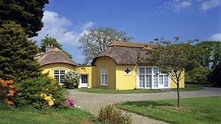
Derrymore House is a National Trust property in Bessbrook, County Armagh, Northern Ireland. The grounds are open to the public most of the year round and the drawing room or "Treaty Room" in the house itself on selected dates only. It is described by the National Trust as a "late 18th-century thatched house in gentrified vernacular style".

Boneybefore is a village near Carrickfergus in County Antrim, Northern Ireland. It lies between the A2 road and Belfast Lough. It is home to the Andrew Jackson Centre, the ancestral home of Andrew Jackson, 7th President of the United States.
The High Sheriff of Down is the Sovereign's judicial representative in County Down. Initially an office for lifetime, assigned by the Sovereign, the High Sheriff became annually appointed from the Provisions of Oxford in 1258. Besides his judicial importance, he has ceremonial and administrative functions and executes High Court Writs.
The NCU Challenge Cup, also called the NCU Senior Challenge Cup and the NCU Senior Cup, is the most important provincial cricket knock-out cup of the NCU jurisdiction in Ireland. The competition began in 1887, with eleven clubs participating in the first competition, North Down eventually beating North of Ireland in the final at Ormeau.

The siege of Carrickfergus took place in August 1689 when a force of Williamite troops under Marshal Schomberg landed and laid siege to the Jacobite garrison of Carrickfergus in Ireland. After a week the Jacobites surrendered, and were allowed to march out with the honours of war.
The Lawn is a cricket ground in Waringstown, County Down, Northern Ireland.
