Related Research Articles

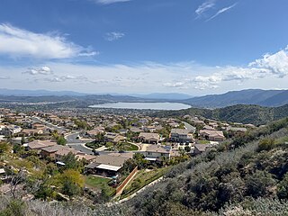
Lake Elsinore is a city in western Riverside County, California, United States. Established as a city in 1888, it is on the shore of Lake Elsinore, a natural freshwater lake about 3,000 acres (1,200 ha) in size. The city has grown from a small resort town in the late 19th and early 20th centuries to a suburban city with over 70,000 residents.

Lake Elsinore is a natural freshwater lake in Riverside County, California, United States, located east of the Santa Ana Mountains and fed by the San Jacinto River. Originally named Laguna Grande by Spanish explorers, it was renamed for the town of Elsinore, established on its northeastern shore on April 9, 1888.

The San Jacinto River is a 42-mile-long (68 km) river in Riverside County, California. The river's headwaters are in Santa Rosa and San Jacinto Mountains National Monument. The lower portion of the 765-square-mile (1,980 km2) watershed is urban and agricultural land. As a partially endorheic watershed that is contiguous with other Great Basin watersheds, the western side of the San Jacinto Basin is a portion of the Great Basin Divide.

The Temecula Valley is a graben rift valley in western Riverside County, California.

San Mateo Creek is a stream in Southern California in the United States, whose watershed mostly straddles the border of Orange and San Diego Counties. It is about 22 miles (35 km) long, flowing in a generally southwesterly direction. Draining a broad valley bounded by the Santa Ana Mountains and Santa Margarita Mountains, San Mateo Creek is notable for being one of the last unchannelized streams in Southern California.

Temescal Creek is an approximately 29-mile-long (47 km) watercourse in Riverside County, in the U.S. state of California. Flowing primarily in a northwestern direction, it connects Lake Elsinore with the Santa Ana River. It drains the eastern slopes of the Santa Ana Mountains on its left and on its right the western slopes of the Temescal Mountains along its length. With a drainage basin of about 1,000 square miles (2,600 km2), it is the largest tributary of the Santa Ana River, hydrologically connecting the 720-square-mile (1,900 km2) San Jacinto River and Lake Elsinore watersheds to the rest of the Santa Ana watershed. However, flowing through an arid rain shadow zone of the Santa Ana Mountains, and with diversion of ground water for human use, the creek today is ephemeral for most of its length, except for runoff from housing developments and agricultural return flows.
Alberhill is an unincorporated community in Riverside County, California. Alberhill is located 5.5 miles (8.9 km) northwest of Lake Elsinore. It lies at an elevation of 1234 feet. Alberhill was named after C.H. Albers and James and George Hill.
The Elsinore Trough is a graben rift valley in Riverside County, southern California. It is created by the Elsinore Fault Zone.

Temescal Mountains, also known as the Sierra Temescal, are one of the northernmost mountain ranges of the Peninsular Ranges in western Riverside County, in Southern California in the United States. They extend for approximately 25 mi (40 km) southeast of the Santa Ana River east of the Elsinore Fault Zone to the Temecula Basin and form the western edge of the Perris Block.
Temescal Valley in California is a graben rift valley in western Riverside County, California, a part of the Elsinore Trough. The Elsinore Trough is a graben between the Santa Ana Mountain Block to the southwest and the Perris Block on the northeast. It is a complex graben, divided lengthwise into several smaller sections by transverse faults. The Temescal Valley is one of these graben, at the northern end of the trough. The Temescal Valley graben is bounded northeast side by the Lee Lake longitudinal fault and similarly on the southeast by the Glen Ivy Fault.
Elsinore Valley is a graben rift valley in western Riverside County, California, a part of the Elsinore Trough. The Elsinore Valley is a graben between the Santa Ana Block to the southwest and the Perris Block on the northeast. It is a complex graben, divided lengthwise into several smaller sections by transverse faults.

The Clevelin Hills are a range of hills in the Peninsular Ranges System, within the Temescal Mountains in western Riverside County, in southern California.
The Perris Block is the central block of three major fault-bounded blocks of the northern part of the Peninsular Ranges. The Perris Block lies between the Santa Ana Block to the west and the San Jacinto Block to the east. The Perris Block, was named by Walter A. English in 1925 for the city of Perris, located near the center of the block.
The Plains of Leon are named for the former gold mining town, Leon once located near the middle of the plain. It is a plain in the Perris Block, contiguous on the south with the Perris Plain including within it the Domenigoni Valley and western Diamond Valley, French Valley, Auld Valley, the upper part of the valley of Warm Springs Creek and connecting tablelands.
Rice Canyon Creek is a tributary creek or arroyo of Temescal Creek in Riverside County, California. Rice Canyon Creek has its source at the head of Rice Canyon at an elevation of 3440 feet in the Santa Ana Mountains at 33°41′54″N117°24′11″W east of the 4313 foot peak on the north south divide of the range. It is a wash that runs down from the canyon mouth 33°41′07″N117°27′08″W at 1631 feet to its mouth at its confluence with Temescal Creek near Alberhill, California at an elevation of 1220 feet. Rice Canyon Creek has a tributary, Bishop Canyon Creek which enters the wash on the left a little below the mouth of Rice Canyon at 33°42′05″N117°24′07″W.
Gavilan Hills, sometimes called the Gavilan Mountains, are a range of the Temescal Mountains, in Riverside County, California. The name given them came from local New Mexican and Californio miners of the mountains and Gavilan Plateau. In Spanish Gavilan, means "sparrow hawk".
Cajalco Canyon Creek is an ephemeral stream that flows through Cajalco Canyon in the Temescal Mountains of Riverside County, California, United States. It is a tributary to Temescal Wash, itself a tributary to the Santa Ana River. Cajalco is thought to be a Hispanic spelling of the word for "quail" in the languages of the Luiseño and Cahuilla who lived in the area. The word Cajalco is an acronym- California Jalisco Land Company of Los Angeles

Walker Canyon is a canyon in the Temescal Mountains, in Riverside County, California. It lies divides Alberhill Summit, on the west and the balance of the range to its east. Temescal Creek flows northward through the canyon from where it heads at 33°42′33″N117°21′43″W in Warm Springs Valley into the upper reach of the Temescal Valley near Alberhill, California. Coming from the Temescal Mountains to the east, Gavilan Wash has its confluence with Walker Canyon near mid way along its length, and Alberhill Canyon has its confluence with Walker Canyon at its mouth.
Eagle Valley is a basin in the Temescal Mountains, of Riverside County, California. It has an elevation of 1,283 feet. The basin is overlooked by summits of the Temescal Mountains on the west, north and east, the tallest is 1,857-foot Arlington Mountain on the northeast. The valley is drained by three streams, the primary one, has its source on the south slope of Arlington Mountain and drains southwestward into Cajalco Canyon and Cajalco Canyon Creek.