You can help expand this article with text translated from the corresponding article in French. (May 2018)Click [show] for important translation instructions.
View a machine-translated version of the French article.
Machine translation, like DeepL or Google Translate, is a useful starting point for translations, but translators must revise errors as necessary and confirm that the translation is accurate, rather than simply copy-pasting machine-translated text into the English Wikipedia.
Do not translate text that appears unreliable or low-quality. If possible, verify the text with references provided in the foreign-language article.
You must provide copyright attribution in the edit summary accompanying your translation by providing an interlanguage link to the source of your translation. A model attribution edit summary is Content in this edit is translated from the existing French Wikipedia article at [[:fr:Warndt]]; see its history for attribution.
You may also add the template {{Translated|fr|Warndt}} to the talk page.
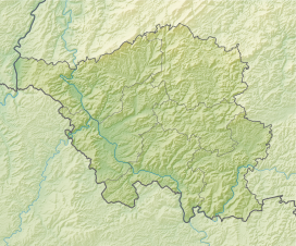
The Warndt (French pronunciation:[vaʁnt]) is an extensive forest area of approximately 5,000 hectares (19sqmi) including parts of the German Saarland and the French region Grand Est west of Saarbrücken. The geology of the Warndt is composed of Buntsandstein permeated by veins of iron ore and deposits of hard coal. Today it is a popular recreational area.
The area is bounded by the Saar and two of its left tributaries, the Bist in the north and the Rossel in the south. It is transected by the Lauterbach, which flows into the Rossel in Geislautern. The name Warndt first appears in a deed of donation from 999AD of the Emperor Otto III.
Off-limits to the general population, the Warndt had been a lordly hunting ground since the Middle Ages. Prince Ludwig of Nassau-Saarbrücken had a hunting lodge built at Karlsbrunn in 1717 and used it frequently for large hunts, often lasting several days. In 1815 the state forestry administration moved into the estate. In the 17th century, the Warndt was a refuge for French Huguenots. Their settlements in the Warndt, in Ludweiler, caused a lasting effect on the area, since they brought the craft of glassblowing and introduced the glass industry to the Saar. The abundance of wood in the Warndt was used to fire the glassworks. Coal mining ended in mid-2005. The art of glassblowing can now be seen in the demonstration factory of Villeroy & Boch in Wadgassen.
Places in the Warndt region
Germany (21): Differten, Dorf im Warndt, Emmersweiler, Fenne, Friedrichweiler, Fürstenhausen, Geislautern, Gersweiler, Großrosseln, Hostenbach, Karlsbrunn, Klarenthal, Lauterbach, Ludweiler-Warndt, Naßweiler, Schaffhausen, St. Nikolaus, Überherrn, Wadgassen, Wehrden, Werbeln
Saarland is a state of Germany in the southwest of the country. With an area of 2,570 km2 (990 sq mi) and population of 990,509 in 2018, it is the smallest German state in area apart from the city-states of Berlin, Bremen, and Hamburg, and the smallest in population apart from Bremen. Saarbrücken is the state capital and largest city; other cities include Neunkirchen and Saarlouis. Saarland is mainly surrounded by the department of Moselle in France to the west and south and the neighboring state of Rhineland-Palatinate in Germany to the north and east; it also shares a small border about 8 kilometres long with the canton of Remich in Luxembourg to the northwest.
Saarbrücken is the capital and largest city of the state of Saarland, Germany. Saarbrücken has 181,959 inhabitants and is Saarland's administrative, commercial and cultural centre. It is located on the Saar River, directly borders the French department of Moselle, and is Germany's second-westernmost state capital after Düsseldorf.
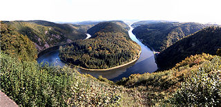
The Saar is a river in northeastern France and western Germany, and a right tributary of the Moselle. It rises in the Vosges mountains on the border of Alsace and Lorraine and flows northwards into the Moselle near Trier. It has two headstreams, that both start near Mont Donon, the highest peak of the northern Vosges. After 246 kilometres (153 mi) the Saar flows into the Moselle at Konz (Rhineland-Palatinate) between Trier and the Luxembourg border. It has a catchment area of 7,431 square kilometres (2,869 sq mi).
Forbach is a commune in the French department of Moselle, northeastern French region of Grand Est.
Saint-Avold is a commune in the Moselle department in Grand Est in north-eastern France.
The Saar Offensive was the French invasion of Saarland, Germany, in the first stages of World War II, from September 7 to October 16, 1939, in response to the German invasion of Poland on 1 September 1939. The original plans called for 40 divisions, and one armored division, three mechanised divisions, 78 artillery regiments and 40 tank battalions to assist Poland, which was then under invasion, by attacking Germany's neglected western front. Despite 30 divisions advancing to the border, the attack did not have the expected result. When the swift victory in Poland allowed Germany to reinforce its lines with homecoming troops, the offensive was halted. French forces then withdrew amid a German counter-offensive on 17 October.
Ensdorf is a municipality in the district of Saarlouis, in Saarland, Germany. It is on the right bank of the river Saar, opposite Saarlouis, approximately 20 km (12 mi) northwest of Saarbrücken.
Wadgassen is a municipality in the district of Saarlouis, in Saarland, Germany. It is situated on the river Saar, approx. 6 km southeast of Saarlouis, and 15 km west of Saarbrücken.
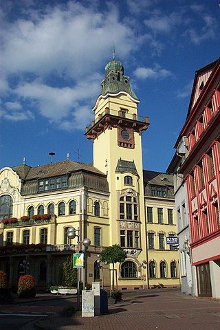
Völklingen is a town in the district of Saarbrücken, in Saarland, Germany. It is situated on the river Saar, approx. 10 km west of Saarbrücken, and directly borders France.
Creutzwald is a commune in the Moselle département in Grand Est in north-eastern France.
The Greater Region, formerly also known as SaarLorLux, is a euroregion of eleven regional authorities located in four European states. The term has also been applied to cooperations of several of these authorities or of their subdivisions, administrations, organisations, clubs and people. Member regions represent different political structures: the Walloon region, comprising the French and German-speaking Communities of Belgium; the former Lorraine part of Grand Est, a region of France, including the French departments Meurthe-et-Moselle, Meuse, Moselle and Vosges; the German federated states of Rhineland-Palatinate and Saarland; and the sovereign state of Luxembourg.
Coal mining regions are significant resource extraction industries in many parts of the world. They provide a large amount of the fossil fuel energy in the world economy.
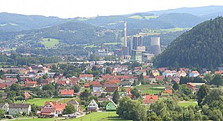
Bärnbach is the smallest city of the district of Voitsberg in the Austrian state of Styria. The city is popular for its church, manual glass manufacturing and coal mining . Today the coal mine is closed, because it is uneconomical.
Karlsbrunn is a German village that is part of the municipality of Großrosseln. It is situated in the district of Saarbrücken, which is part of the federal state of Saarland. Its population is about 1,000 inhabitants.
The Nahe Valley Railway is a two-track, partially electrified main line railway in the German states of Rhineland-Palatinate and Saarland, which runs for almost 100 kilometres along the Nahe. It was built by the Rhine-Nahe Railway Company and connects Bingen am Rhein on the Left Rhine line with Saarbrücken. It was opened between 1858 and 1860 and is one of the oldest railways in Germany. The section south of Bad Kreuznach is part of the regionally important transport corridor between the two major cities of Mainz and Saarbrücken.
The Saarbrücken–Trier railway, known in German as the Saarstrecke in the German states of Rhineland-Palatinate and Saarland. It connects Saarbrücken and Trier. It was opened in 1858 and 1860 and is one of the oldest railways in Germany.
The railway from Rémilly to Saarbrücken is a French and German 55-kilometre long railway line, that connects the French Grand Est region to the German city Saarbrücken. The railway was opened between 1851 and 1852. It is part of the international railway connection between Paris and Frankfurt am Main.
Rossel is a river flowing on the border of the department of Moselle (France) and Saarland (Germany). It rises in Longeville-les-Saint-Avold near the border of France and Germany and flows northwards into the Saar near Völklingen. Its course within France and on the French-German border is 32.8 km (20.4 mi) long.
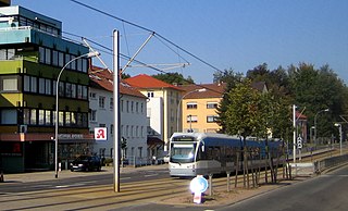
The Saarbahn is a regional Stadtbahn operating on the tram-train principle in the German state of the Saarland. It consists of a core line in Saarbrücken and Riegelsberg operating under tram operating procedures (BOStrab), connected to two lines that are operated under railway operating procedures (EBO), the Lebach–Völklingen railway to the north and the Saarbrücken–Sarreguemines railway in the south. Stadtbahn Saar GmbH is responsible for the infrastructure of the central section of line, while the outer tracks are operated by the national railway infrastructure companies, DB Netz AG in Germany and Réseau Ferré de France in France. The system is operated by Saarbahn GmbH, and integrated in the Saarländischer Verkehrsverbund (SaarVV).
The Carreau Wendel Museum is the museum of the Wendel-Vuillemin coal pit, in Petite-Rosselle on the Saarland, Lorraine border. Though often in Germany, since 1945 it has been in Moselle department France. The museum is an Anchor point on the European Route of Industrial Heritage.
This page is based on this Wikipedia article Text is available under the CC BY-SA 4.0 license; additional terms may apply. Images, videos and audio are available under their respective licenses.