
Warruwi is a town located in the Arnhem Land region in the Northern Territory of Australia. At the 2016 census, Warruwi had a population of 389.
Warruwi is a town located in the Arnhem Land region in the Northern Territory of Australia. At the 2016 census, Warruwi had a population of 389.
The demography of Australia covers basic statistics, most populous cities, ethnicity and religion. The population of Australia is estimated to be 25,560,400 as of 22 December 2019. Australia is the 52nd most populous country in the world and the most populous Oceanian country. Its population is concentrated mainly in urban areas and is expected to exceed 28 million by 2030.
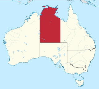
The Northern Territory is a federal Australian territory in the central and central northern regions of Australia. It is the third largest Australian federal division with an area of 1,348,094.3 square kilometres (520,502 sq mi) but the least populous with 247,327 inhabitants as at June 2018. The Northern Territory is divided administratively into 17 Local government areas (LGAs) generally known as Councils who are responsible for providing local government services.

Brisbane is the capital of and the most populated city in the Australian state of Queensland, and the third most populous city in Australia. Brisbane's metropolitan area has a population of approximately 2.5 million, and the South East Queensland metropolitan region, centred on Brisbane, encompasses a population of more than 3.6 million.

Gippsland is a rural region of Victoria, Australia, located in the south-eastern part of that state. It covers an area of 41,556 square kilometres (16,045 sq mi), and lies to the east of the eastern suburbs of Greater Melbourne, to the north of Bass Strait, to the west of the Tasman Sea, to the south of the Black-Allan Line that marks part of the Victorian/New South Wales border, and to the east and southeast of the Great Dividing Range that lies within the Hume region and the Victorian Alps. Gippsland is generally broken down into the East Gippsland, South Gippsland, West Gippsland, and the Latrobe Valley statistical divisions.

North Canberra, also known as the Inner North, is a district of Canberra, the capital city of Australia, comprising 14 suburbs. At the 2016 census, it had 21,555 dwellings housing 53,002 people of the 397,397 people in the Australian Capital Territory. Many of Canberra's oldest dwellings are in this district.

The Hills Shire is a local government area in the Greater Western Sydney region of Sydney, New South Wales, Australia. The suburb is north-west of the Sydney central business district, and encompasses 401 square kilometres (155 sq mi) stretching from the M2 Hills Motorway in the south to Wiseman's Ferry on the Hawkesbury River in the north. The Hills Shire had a population of 157,243 as at the 2016 census.
As of 2018, the world's Core Jewish Population, those identifying as Jews above all else, was 14.6 million. The Connected Jewish Population, including those who say they are partly Jewish or that have Jewish background from at least one Jewish parent, in addition to the Core Jewish Population, was 17.8 million. The Enlarged Jewish Population, including those who say they have Jewish background but not a Jewish parent, and all non-Jewish household members who live in households with Jews, in addition to the Jewish Connected Population, was 20.7 million. And the Law of Return Jewish Population, which counts all those eligible to immigration to Israel under its Law of Return, 23.5 million.
The Goulburn Islands are a group of small islands and islets in the Arafura Sea off the coast of Arnhem Land in Northern Territory of Australia. The largest islands are the North and South Goulburn Islands where the climate is slightly cooler than in Darwin. The Maung Aboriginal people are the traditional owners of the Goulburn Islands.
Although Australia has no official languages, English has been entrenched as the de facto national language since European settlement. Australian English is a major variety of the language with a distinctive accent and lexicon, and differs slightly from other varieties of English in grammar and spelling. General Australian serves as the standard dialect.

The Iwaidjan or Yiwaidjan languages are a small family of non-Pama–Nyungan Australian Aboriginal languages spoken in the Cobourg Peninsula region of Western Arnhem Land.

Government in the Commonwealth of Australia is exercised on three levels: federal, states and territories, and local government.

Victoria is a state in south-eastern Australia. Victoria is Australia's smallest mainland state and its second-most populous state, making it the most densely populated state. Most of its population lives concentrated in the area surrounding Port Phillip Bay, which includes the metropolitan area of its state capital and largest city, Melbourne, Australia's second-largest city. Victoria is bordered by Bass Strait and Tasmania to the south, New South Wales to the north, the Tasman Sea to the east, and South Australia to the west.

The census in Australia, or officially, the Census of Population and Housing, collects key characteristic data on every person in Australia, and the place they are staying in, on a particular night. The census is the largest statistical collection compiled by the Australian Bureau of Statistics and is held every five years. Participation in the census is compulsory, although answering some questions is optional. The Australian Bureau of Statistics is legislated to collect, hold and disseminate census data under the Australian Bureau of Statistics Act 1975, and the Census and Statistics Act 1905.
The Australian Bureau of Statistics (ABS) is the independent statistical agency of the Government of Australia. The ABS provides key statistics on a wide range of economic, population, environmental and social issues, to assist and encourage informed decision making, research and discussion within governments and the community.

The Grampians is an economic rural region located in the western part of Victoria, Australia. The 48,646-square-kilometre (18,782 sq mi) region lies to the northwest of the western suburbs of Greater Melbourne, to the state's western border with South Australia and includes the Grampians National Park and significant gold mining heritage assets. The Grampians region has two sub-regions, Grampians Central Highlands and Wimmera Southern Mallee.
The Maung, or Warruwi are the indigenous Australian people living on the Goulburn Islands in the Arafura sea off the coast of the Northern Territory.
The 2016 Australian census was the seventeenth national population census held in Australia. The census was officially conducted with effect on Tuesday, 9 August 2016. The total population of the Commonwealth of Australia was counted as 23,401,892 – an increase of 8.8 per cent or 1,894,175 people since the 2011 census. Norfolk Island joined the census for the first time in 2016, adding 1,748 to the population.