
Saxon Switzerland is a hilly climbing area and national park around the Elbe valley south-east of Dresden in Saxony, Germany. Together with the Bohemian Switzerland in the Czech Republic it forms the Elbe Sandstone Mountains.

The Elbe Sandstone Mountains, also called the Elbe Sandstone Highlands, are a mountain range straddling the border between the state of Saxony in southeastern Germany and the North Bohemian region of the Czech Republic, with about three-quarters of the area lying on the German side. In both countries, core parts of the mountain range have been declared a national park. The name derives from the sandstone which was carved by erosion. The river Elbe breaks through the mountain range in a steep and narrow valley.

A rockfall or rock-fall is a quantity/sheets of rock that has fallen freely from a cliff face. The term is also used for collapse of rock from roof or walls of mine or quarry workings. "A rockfall is a fragment of rock detached by sliding, toppling, or falling, that falls along a vertical or sub-vertical cliff, proceeds down slope by bouncing and flying along ballistic trajectories or by rolling on talus or debris slopes."

Rathen is a village in the Elbe Sandstone Mountains, in Saxony, Germany, about 35 kilometres (22 mi) southeast of Dresden. The village occupies both banks of the river Elbe and, as of 2020, has 339 inhabitants. Rathen is a popular tourist destination, the main sights are the Bastei cliffs, the Amselsee, and the outdoor theater "Felsenbühne Rathen".

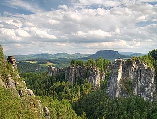
The Bastei is a rock formation rising 194 metres above the Elbe River in the Elbe Sandstone Mountains of Germany. Reaching a height of 305 metres above sea level, the jagged rocks of the Bastei were formed by water erosion over one million years ago. They are situated near Rathen, not far from Pirna southeast of the city of Dresden, and are the major landmark of the Saxon Switzerland National Park. They are also part of a climbing and hiking area that extends over the borders into the Bohemian Switzerland.
Saxon Switzerland National Park, is a national park in the German Free State of Saxony, near the Saxon capital Dresden. It covers two areas of 93.5 km² (36.1 mi²) in the heart of the German part of the Elbe Sandstone Mountains, which is often called (the) Saxon Switzerland.

The Rathen Ferry is a passenger cable ferry across the Elbe river at Rathen in Saxony, Germany. It connects Niederrathen, on the east bank, to Oberrathen, on the west bank. Kurort Rathen railway station, on the Dresden S-Bahn, is about 200 metres (660 ft) from the Oberrathen ferry terminal. The Niederrathen ferry terminal provides access to the famous Bastei cliffs, to the Amselsee lake, and the Felsenbühne Rathen outdoor theatre.

The Nonne is a roughly 18-metre-high, isolated, standing sandstone rock and climbing peak in Saxon Switzerland in Germany. The rock is located southeast of Rathen, east of the rock chain of Rauenstein.

The Lokomotive is a striking climbing rock north of Kurort Rathen in Saxon Switzerland in Germany. The rock, which resembles a steam locomotive in appearance, is also known as Große Ruine, is about 30 metres high and is divided into two parts: known as Lokomotive-Dom and Lokomotive-Esse. The ridge between the two is called the Kesselgrat, the rock teeth next to the Esse as Pfeife ("Whistle"). For a short time there was a weather vane on the dome in the shape of a wheel. The Lokomotive rises on the massif of the Honigsteine.
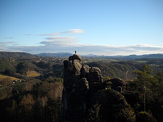
The Mönch is a rock pinnacle and popular climbing peak in Saxon Switzerland in Germany near the spa town of Rathen. The weather vane on the summit, in the shape of a tin monk, is visible from afar and acts as a navigation aid.

Saxon Switzerland is the largest and one of the best-known climbing regions in Germany, located in the Free State of Saxony. The region is largely coterminous with the natural region of the same name, Saxon Switzerland, but extends well beyond the territory of the National Park within it. It includes the western part of the Elbe Sandstone Mountains and is the oldest non-Alpine climbing region in Germany. Its history of climbing dates back to the first ascent in modern times of the Falkenstein by Bad Schandau gymnasts in 1864. Currently, there are over 1,100 summits with more than 17,000 climbing routes in the Saxon Switzerland area.

The Rauenstein is a table hill in Saxon Switzerland in Germany. It rises west of the Elbe inside the Elbe loop near Rathen. It has a height of 304 metres and drops steeply to the north into the Elbe valley. It has a deeply incised structure and is about 600 metres long and 200 metres wide. It thus rises almost 100 metres over the surrounding area. The Rauenstein is almost completely wooded, but has several dominant sandstone rock faces. The sandstone here is very soft and heavily weathered.

The Schwedenturm in East Germany is a 35-metre-high rock formation made of sandstone in the hills of Saxon Switzerland near the spa town of Rathen and the famous Bastei rocks. From the car park for the Bastei, a path runs towards Schwedenlöcher. The Schwedenturm is situated on the right just before the entrance to a narrow ravine. Because it lies in the Saxon Switzerland Climbing Region the free-standing pinnacle may be used for climbing. Currently there are 14 different routes up the rock. It was here that the first grade Xb route in the mountain range was successfully climbed, route 6 (Versuch), by Bernd Arnold. The Schwedenturm was first climbed in 1905 by Rudolf Fehrmann and his brother Arymund.

The Rathen Open Air Stage is a natural stage in Saxon Switzerland in East Germany. It is located in a hollow at the upper end of the Wehlgrund valley between the rocks of Kleine Gans and Großer Wehrturm below the famous Bastei rocks and Neurathen Castle. The entrance to the hollow branches off just above the valley's junction with the Amselgrund.
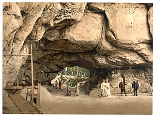
The Kuhstall is the second largest natural arch in the Elbe Sandstone Mountains after the Pravčická brána. It is located on the Neuer Wildenstein, a 337 m high rock outcrop in the hinterland of Saxon Switzerland, south of the Lichtenhain Waterfall and above the Kirnitzsch valley. It is crowned by the 15th-century castle of Wildenstein. The arch is 11 metres high, 17 metres wide and 24 metres deep.
The Amsel Falls are a waterfall in Saxon Switzerland in East Germany, roughly a kilometre north of the famous Bastei crags.

The Amselgrund is the name given to the valley of the Grünbach stream in the heart of Saxon Switzerland in Eastern Germany. It runs from Niederrathen upstream to Rathewalde. The wild and romantic valley takes hikers through the Rathen rock basin with its bizarre rock formations. Its touristic high points are the lake of Amselsee and the Amsel Falls, that trickles over the grotto called the Amselloch. The valley bottom that is densely wooded is surrounded by a backdrop of rocks. To the west tower the rocks of the Gansfelsen, to the south the Feldsteine and the Türkenkopf, and to the east rise the Honigsteine rocks with the striking Lokomotive. The middle of the valley bottom is dominated by the striking Talwächter. Whilst the character of the valley profile in its upper reaches is rather ravine-like, between its entrance to the Schwedenlöcher and Niederrathen it is a steep valley. On the stream bed ripple marks may be seen. Above the Amsel Falls, large, fallen sandstone boulders block the watercourse, so that the rather lower water quantities of the Grünbach have to find their way past them.
The Wehlgrund in Saxon Switzerland in Eastern Germany is a right-hand, side valley of the Amselgrund, between the Bastei massif and the Kleiner Gans. Amongst the steep rock faces of the upper valley and the heavily divided head of the valley is the romantic and natural backdrop for the Rathen Open Air Stage. The Wehlgrundbach flows along the valley bottom and empties into the Grünbach in the Amselgrund valley a short distance above Niederrathen. North of the open air stage near the rocks of the Gänse rises the imposing Wehlnadel and, in its vicinity, are the Wehltürme rock towers. The Bastei may be reached from the Wehlgrund over the Rathen Staircase of 487 steps.

The Kleiner Bärenstein is a 338 metres high table hill in the German region of Saxon Switzerland in the Free State of Saxony. Close by is the Großer Bärenstein which, together with the Kleiner Bärenstein, forms the massif of the Bärensteine.

The Schwedenlöcher is a gorge-like side valley of the Amselgrund near Rathen in Saxon Switzerland.


