Washington Square, Syracuse

Last updated

Neighborhood in Syracuse
Washington Square
Washington Square, Syracuse, New York.jpg
Washington Square Park
Washington Square, Syracuse
CountryUnited States
State New York
County Onondaga County
City Syracuse
Population
 (2020)
  Total
22,833

Washington Square is one of the 26 officially recognized neighborhoods of Syracuse, New York.

Contents

Description

Washington Square encompasses what used to be the old Village of Salina which has a concentration of two, three, and four- family structures, and larger apartments surrounded by single-family homes. The neighborhood contains mixed-use buildings along the North Salina Street corridor. Washington Square has the most historic rooming/boarding houses out of all the city's neighborhoods. Historic multiple residences ranked second highest, and apartment buildings ranked seventh. Almost 50 percent of Washington Square's mixed-use buildings have historic significance.

The North Salina Street Historic District runs from the 500 Block (where Prospect Street meets N. Salina Street), to the end of the 900 block at Union Place. The City of Syracuse hired a consultant to initiate a streetscape enhancement plan, which includes improved sidewalks, new street furniture, improved parking, new landscaping, interpretive historic markers, and a pedestrian friendly atmosphere. This is intended to be a catalyst for store owners to rehabilitate or improve their own storefronts in order to attract more businesses to locate on this once magnificent 19th Century commercial strip.

The Washington Square neighborhood consists of a mix of residential, commercial and industrial sectors. Businesses are concentrated along North Salina, North State Street, East Hiawatha Boulevard, and Wolf Street. Retail, professional, service, wholesale, and industrial type businesses populate the area. Franklin Elementary is the school located in the neighborhood.

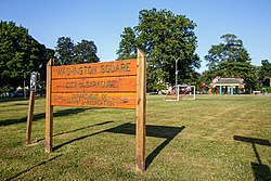
Schiller Park serves the needs for this area. Woodlawn Cemetery, though not a park, is often used for dog walking and strolling by the neighbors. Washington Square Park lies in the far western corner, along North Salina Street.

In addition to the North Salina Street Historic District, the Chapman House and Gang House are listed on the National Register of Historic Places. [1]

Geography

It borders three other Syracuse neighborhoods, with Northside to the east, Near Northeast to the southeast, and Lakefront to the west.

Related Research Articles

<span class="mw-page-title-main">Syracuse, New York</span> City in New York, United States

Syracuse is a city in and the county seat of Onondaga County, New York, United States. With a population of 148,620 and a metropolitan area of 662,057, it is the fifth-most populated city and 13th-most populated municipality in the state of New York.

<span class="mw-page-title-main">Salina, New York</span> Town in New York, United States

Salina is a town in Onondaga County, New York, United States. As of the 2020 census, the population was 33,223. The name of the town is derived from the Latin word for "salt." Salina is a northern suburb of Syracuse.

<span class="mw-page-title-main">Armory Square</span> United States historic place

Armory Square is a small neighborhood on the west side of Downtown Syracuse, New York. It began life as a busy commercial and industrial area just to the west of the central city. After World War II, Syracuse's central city became less and less populated as more housing and business facilities were built in the suburbs. In the 1980s, plans were first made to transform the languishing district into a small shopping/arts/nightlife district surrounding the former Syracuse Armory. These plans came to fruition during the 1990s, when new stores and restaurants opened, and several new buildings were constructed in a compatible style to the middle and late 1800s and early 1900s architecture dominating the district.

<span class="mw-page-title-main">Downtown Syracuse</span>

Downtown Syracuse is the economic center of Syracuse, New York, and Central New York, employing over 30,000 people, and housing over 4,300.

<span class="mw-page-title-main">Westcott, Syracuse</span> Neighborhood in Syracuse, New York, United States

Westcott is a neighborhood in Syracuse, New York, United States. Its proximity to Syracuse University makes for a diverse community, home to Syracuse University students, professors and other faculty and staff, as well as residents at all income levels. Westcott Street is the main retail street of the neighborhood, featuring numerous restaurants, coffee shops, stores and The Westcott Theater performing arts venue. It is the site of the annual Westcott Street Cultural Fair, a one-day event with food, art, live performances and cultural activities. Westcott is also home to Thornden Park, one of the largest parks in Syracuse. The Westcott neighborhood is the boyhood home of renowned banjoist Tony Trischka.

<span class="mw-page-title-main">Washington Square West, Philadelphia</span> United States historic place

Washington Square West is a neighborhood in Center City, Philadelphia, Pennsylvania, United States. The neighborhood roughly corresponds to the area between 7th and Broad Streets and between Chestnut and South Streets, bordering on the Independence Mall tourist area directly northeast, Market East to the north, Old City and Society Hill to the East, Bella Vista directly south, Hawthorne to the southwest, and mid-town Philadelphia and Rittenhouse Square to the west. The area takes its name from Washington Square, a historic urban park in the northeastern corner of the neighborhood. In addition to being a desirable residential community, it is considered a hip, trendy neighborhood that offers a diverse array of shops, restaurants, and coffee houses. Washington Square West contains many gay-friendly establishments, especially in the gay village area of the neighborhood commonly known as the Gayborhood, which hosts annual events celebrating LGBT culture in Philadelphia, including OutFest.

<span class="mw-page-title-main">University Neighborhood, Syracuse</span> Neighborhood of Syracuse, New York

The University Neighborhood is one of Syracuse, New York's 26 officially recognized neighborhoods. It borders the neighborhoods of Westcott to the north, University Hill to the west, Outer Comstock to the southwest, Skytop to the south, and Meadowbrook to the east.

Southside is one of the 26 official neighborhoods in Syracuse, New York.

The Northside is a neighborhood in the city of Syracuse, New York (USA) consisting of a residential area bordered by commercial corridors. As defined by Syracuse's "Tomorrow's Neighborhoods Today" planning system, the Northside is a large section of the city of Syracuse, covering almost four square miles. There are 16 census tracts, within which are 36 census blockgroups. Thus, there are many sub-regions that have developed with their own unique identities, such as the Near Northeast neighborhood, the Little Italy District and the Hawley-Green Historic District.

<span class="mw-page-title-main">Westside, Syracuse</span>

Westside is a Syracuse, New York neighborhood, directly west of Downtown Syracuse. It corresponds to Onondaga County Census Tracts 21 and 22. It is made up of three parts, near West side, far west side and the West side

<span class="mw-page-title-main">Near Northeast, Syracuse</span> Neighorhood in New York, United States

Near Northeast is a Syracuse, New York neighborhood, located northeast of the city's downtown. It corresponds to Onondaga County Census Tract 15, 16, 23, and 24.

<span class="mw-page-title-main">Neighborhoods of Milwaukee</span>

The neighborhoods of Milwaukee include a number of areas in southeastern Wisconsin within the state's largest city at nearly 600,000 residents.

Lakefront is one of the 26 officially recognized neighborhoods of Syracuse, New York. It borders five other Syracuse neighborhoods, with Washington Square and Near Northeast to the east, Downtown Syracuse to the southeast, and Westside and Far Westside to the south.

<span class="mw-page-title-main">Central Troy Historic District</span> Historic district in New York, United States

The Central Troy Historic District is an irregularly shaped, 96-acre (39 ha) area of downtown Troy, New York, United States. It has been described as "one of the most perfectly preserved 19th-century downtowns in the [country]" with nearly 700 properties in a variety of architectural styles from the early 19th to mid-20th centuries. These include most of Russell Sage College, one of two privately owned urban parks in New York, and two National Historic Landmarks. Visitors ranging from the Duke de la Rochefoucauld to Philip Johnson have praised aspects of it. Martin Scorsese used parts of downtown Troy as a stand-in for 19th-century Manhattan in The Age of Innocence.

<span class="mw-page-title-main">Remington, Baltimore</span> Neighborhood of Baltimore in Maryland, United States

Remington is a neighborhood in northern Baltimore bordered to the north by Hampden, Wyman Park, and Johns Hopkins University and to the east by Charles Village. The southernmost boundary is North Avenue and the long southwestern boundary is formed by Falls Road in the I-83 corridor. The neighborhood is split between two Baltimore City Council Districts.

<span class="mw-page-title-main">University Hill, Syracuse</span> Neighborhood and business district in Syracuse, New York

University Hill is a neighborhood and business district in Syracuse, New York, located east and southeast of Downtown Syracuse, on one of the larger hills in Syracuse. The neighborhood is bounded on the west by Almond Street and Interstate 81. It continues east to Ostrom Avenue and Thornden Park, where it borders the Westcott and University neighborhoods. Interstate 690 currently serves as the neighborhood's northern boundary.

<span class="mw-page-title-main">Mount Vernon Triangle</span> Place in the United States

Mount Vernon Triangle is a neighborhood and community improvement district in the northwest quadrant of Washington, D.C. The neighborhood is located adjacent to Mount Vernon Square. Originally a working-class neighborhood established in the 19th century, present-day Mount Vernon Triangle experienced a decline in the mid-20th century as it transitioned from residential to commercial and industrial use.

<span class="mw-page-title-main">Midtown-Edmondson, Baltimore</span> Neighborhood of Baltimore in Maryland, United States

Midtown-Edmondson is a mixed-use neighborhood in western Baltimore City developed mostly between the 1880s and the 1910s. The neighborhood is mainly composed of residential rowhouses, with a mixed-used business district along Edmondson Avenue, and industrial warehouses and buildings dotted along the CSX railroads that bound its western edge.

<span class="mw-page-title-main">Onondaga Creekwalk</span> Trail in New York

The Onondaga Creekwalk is a mostly paved, partly bricked, multi-use trail running 4.8 miles (7.7 km) in Syracuse, New York, which has so far seen more than three decades of planning, construction, and delays, starting in 1988. The trail is designed for bicyclists, skaters, and pedestrians to approximately parallel any desired portion of Onondaga Creek's run connecting Kirk Park on Syracuse's South Side, downstream through downtown at Armory Square, and then on to Onondaga Lake at the creek's ultimate mouth.

<span class="mw-page-title-main">Southwest Portland, Oregon</span>

Southwest Portland is one of the sextants of Portland, Oregon.

References

  1. "National Register Information System". National Register of Historic Places . National Park Service. July 9, 2010.

43°04′12″N76°09′14″W / 43.070°N 76.154°W / 43.070; -76.154