This article needs to be updated.(October 2020) |
Waterplace Park | |
---|---|
Location | Providence, Rhode Island |
Coordinates | 41°49′25″N71°24′27″W / 41.8237113°N 71.4075563°W |
Created | 1994 |
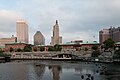
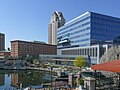
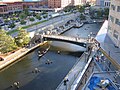
Waterplace Park is an urban park situated along the Woonasquatucket River in downtown Providence, Rhode Island at the original site of the Great Salt Cove. Finished in 1994, Waterplace Park is connected to 3/4 mile of cobblestone-paved pedestrian walkways along the waterfront known as Riverwalk. Venice-styled Pedestrian bridges cross the river. Most of Riverwalk is below street level and automotive traffic. Waterplace Park and Riverwalk together are host to Providence's popular summertime Waterfire events, a series of bonfires lit on the river accompanied by classical and world music.
Waterplace Park was part of Providence's River Relocation Project, which began in the 1980s. [1]
WaterFire is a sculpture by Barnaby Evans presented on the rivers of downtown Providence, RI. It was first created by Evans in 1994 to celebrate the tenth anniversary of First Night Providence, and has since become a free public art installation. WaterFire's symbolism and interpretation reflects on the recognition that individuals must act together to strengthen and preserve their community.
The East Coast Greenway is a 3,000-mile (4,800 km) pedestrian and bicycle route between Maine and Florida along the East Coast of the United States. The nonprofit East Coast Greenway Alliance was created in 1991 with the goal to use the entire route with off-road, shared-use paths; as of 2021, over 1,000 mi (1,600 km) of the route (35%) meets this criteria. In 2020, the Greenway received over 50 million visits.
Olneyville is a neighborhood in Providence, Rhode Island bordered by Atwells Avenue to the north, U.S. Route 6 to the south and Rhode Island Route 10 to the east. The Woonasquatucket River runs through the southern portion of the neighborhood. The area is roughly triangular.
The Moshassuck River is a river in the U.S. state of Rhode Island. It flows 8.9 miles (14.3 km) from the town of Lincoln to the city of Providence. There are six dams along the river's length.
Riverwalk may refer to:
The Woonasquatucket River is a river in the U.S. state of Rhode Island. It flows approximately 15.8 miles (25.4 km) and drains a watershed of 130 km2 (50 sq mi).
Waterplace Towers is the name of a high-rise residential condominium project in Providence, Rhode Island. The project completed construction in Early 2009, and was developed by Intercontinental Real Estate Corporation.
College Hill is a historic neighborhood of Providence, Rhode Island, and one of six neighborhoods comprising the city's East Side. It is roughly bounded by South and North Main Street to the west, Power Street to the south, Governor Street and Arlington Avenue to the east and Olney Street to the north. The neighborhood's primary commercial area extends along Thayer Street, a strip frequented by students in the Providence area.
The Providence River is a tidal river in the U.S. state of Rhode Island. It flows approximately 8 miles (13 km). There are no dams along the river's length, although the Fox Point Hurricane Barrier is located south of downtown to protect the city of Providence from damaging tidal floods.
The East Side is a collection of neighborhoods in the eastern part of the city of Providence, Rhode Island. It officially comprises the neighborhoods of Blackstone, Hope, Mount Hope, College Hill, Wayland, and Fox Point.
Hartford is a neighborhood located along the western edge of Providence, Rhode Island. Route 6 and the Woonasquatucket River separates it from Olneyville.
Downtown is the central economic, political, and cultural district of the city of Providence, Rhode Island, United States. It is bounded on the east by Canal Street and the Providence River, to the north by Smith Street, to the west by Interstate 95, and to the south by Henderson Street. The highway serves as a physical barrier between the city's commercial core and neighborhoods of Federal Hill, West End, and Upper South Providence. Most of the downtown is listed on the National Register of Historic Places as the Downtown Providence Historic District.
Allendale Mill is a historic mill at 494 Woonasquatucket Avenue in North Providence, Rhode Island, on the banks of the Woonasquatucket River.
The Woonasquatucket River Site (RI-163) is a prehistoric archaeological site in Smithfield, Rhode Island. The site contains Late Archaic artifacts, primarily stone flakes indicative of stone toolmaking activity. It is located in the George Washington Grove Wildlife Management Area, near where the Farnum Pike crosses the Woonasquatucket River.
Principal Riverwalk is a recreational park district along the banks of the Des Moines River in downtown Des Moines, Iowa. After eight years of work, it was completed in January 2013.
Providence is the capital and most populous city of the U.S. state of Rhode Island. The county seat of Providence County, it is one of the oldest cities in New England, founded in 1636 by Roger Williams, a Reformed Baptist theologian and religious exile from the Massachusetts Bay Colony. He named the area in honor of "God's merciful Providence" which he believed was responsible for revealing such a haven for him and his followers. The city developed as a busy port, as it is situated at the mouth of the Providence River at the head of Narragansett Bay.
Weybosset is a Narragansett term for a river crossing where three trails met, and the name of a street in Providence, Rhode Island.
The Los Angeles River bicycle path is a Class I bicycle and pedestrian path in the Greater Los Angeles area running from north to east along the Los Angeles River through Griffith Park in an area known as the Glendale Narrows. The 7.4 mile section of bikeway through the Glendale Narrows is known as the Elysian Valley Bicycle & Pedestrian Path. The bike path also runs from the city of Vernon to Long Beach, California. This section is referred to as LARIO, or more formally, the Los Angeles River Bikeway.
The Tampa Riverwalk is a 2.6-mile-long (4.2 km) open space and pedestrian trail along the Hillsborough River in Tampa, Florida. The Riverwalk extends along most of the downtown Tampa waterfront from the Channelside District on the eastern terminus to the mouth of the Hillsborough River and then north along the riverside to Tampa Heights, forming a continuous path that connects a multitude of parks, attractions, public spaces, and hotels. Among the notable points of interest along the Riverwalk are the Tampa Bay History Center, Amalie Arena, the Tampa Convention Center, Rivergate Tower, Curtis Hixon Waterfront Park, Water Works Park, and the Waterfront Arts District which includes the Tampa Museum of Art, Florida Museum of Photographic Arts, Glazer Children's Museum, and the Straz Center for the Performing Arts. Locations along the Riverwalk play host to many community events, most notably the numerous festivals held at Curtis Hixon Park and the arrival of the "pirate ship" Jose Gasparilla, which moors at the Riverwalk behind the Convention Center during the Gasparilla Pirate Festival.
Woodward, Wm Mckenzie. Guide to Providence Architecture. 1st ed. 2003: United States. p 305.
Parks in Providence, Rhode Island |
---|
Burnside Park · India Point Park · Prospect Terrace Park · Roger Williams National Memorial · Roger Williams Park · Waterplace Park |