Watling Chase Community Forest

Last updated
Watling Chase Timberland Trail in Shenley Shenley, Watling Chase Timberland Trail - geograph.org.uk - 1385640.jpg
Watling Chase Timberland Trail in Shenley

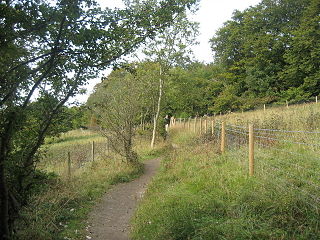
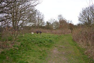
Watling Chase Community Forest is an area of 72 square miles located in north London and south Hertfordshire around the towns of Potters Bar, Radlett, Borehamwood and Barnet. [1] [2] It includes Aldenham Country Park, Scratchwood, Moat Mount Open Space and the Watling Chase Timberland Trail, a waymarked walk of 16 kilometres. [3]

London Capital of the United Kingdom

London is the capital and largest city of both England and the United Kingdom. Standing on the River Thames in the south-east of England, at the head of its 50-mile (80 km) estuary leading to the North Sea, London has been a major settlement for two millennia. Londinium was founded by the Romans. The City of London, London's ancient core − an area of just 1.12 square miles (2.9 km2) and colloquially known as the Square Mile − retains boundaries that follow closely its medieval limits. The City of Westminster is also an Inner London borough holding city status. Greater London is governed by the Mayor of London and the London Assembly.

Hertfordshire County of England

Hertfordshire is one of the home counties in England. It is bordered by Bedfordshire and Cambridgeshire to the north, Essex to the east, Greater London to the south, and Buckinghamshire to the west. For government statistical purposes, it is placed in the East of England region.

Potters Bar town in Hertfordshire, England

Potters Bar is a town in Hertfordshire, England, 13 miles (21 km) north of London. In 2011, it had a population of 21,882.

It was set up in 1991 and is one of twelve community forests in England set up to regenerate the countryside in and around urban areas. They are sponsored by Natural England and the Forestry Commission which work with local authorities and voluntary bodies to manage them. [2]

Natural England is a non-departmental public body in the United Kingdom sponsored by the Department for Environment, Food and Rural Affairs. It is responsible for ensuring that England's natural environment, including its land, flora and fauna, freshwater and marine environments, geology and soils, are protected and improved. It also has a responsibility to help people enjoy, understand and access the natural environment.

The Forestry Commission is a non-ministerial government department responsible for forestry in England. It was formerly also responsible for Forestry in Wales and Scotland, however on 1 April 2013 Forestry Commission Wales merged with other agencies to become Natural Resources Wales, whilst two new bodies were established in Scotland on 1 April 2019. The commission was set up in 1919 to expand Britain's forests and woodland after depletion during the First World War. To do this, the commission bought large amounts of former agricultural land, eventually becoming the largest land owner in Britain. The Commission is divided into three divisions: Forestry England, Forestry Commission and Forest Research.

See also

Related Research Articles

Mio, Michigan Census-designated place & unincorporated community in Michigan, United States

Mio is an unincorporated community in the U.S. state of Michigan. It is the county seat of Oscoda County and is situated along the boundary between Mentor Township on the east, Big Creek Township on the west, and Elmer Township to the northwest.

Icknield Way

The Icknield Way is an ancient trackway in southern and eastern England that goes from Norfolk to Wiltshire. It follows the chalk escarpment that includes the Berkshire Downs and Chiltern Hills.

Lee Valley Park park in the Lee Valley

Lee Valley Regional Park is a 10,000-acre (40 km2) 26 miles (42 km) long linear park, much of it green spaces, running through the northeast of Greater London, Essex and Hertfordshire from the River Thames to Ware, through areas such as Stratford, Clapton, Tottenham, Enfield, Walthamstow, Cheshunt, Broxbourne and Hoddesdon in an area generally known as the Lea Valley. Greater London's largest park, Lee Valley Park is more than four times the size of Richmond Park, extending beyond Greater London's borders into the neighbouring counties of Hertfordshire and Essex.

Capel Manor College

Capel Manor College is a further education college at Bulls Cross, Enfield, London, England.

Aldenham Country Park

Aldenham Country Park is a 175-acre (0.71 km2) parkland and woodland, including Aldenham Reservoir. It is now part of the Watling Chase Community Forest, near Elstree, Hertfordshire, England.

Aldbury Nowers

Aldbury Nowers is a 19.7 hectare biological Site of Special Scientific Interest (SSSI) in the Chiltern Hills, north-east of Tring in Hertfordshire. The site was notified in 1990 under the Wildlife and Countryside Act 1981. It is managed by the Hertfordshire and Middlesex Wildlife Trust. The site, formerly known as "Duchie's Piece," comprises two areas of hillside, linked by The Ridgeway. The calcareous meadow element of the site hosts the flowers of chalk grassland and has butterfly habitats with thirty-four different species of butterfly recently recorded, including the Duke of Burgundy, hairstreaks and the Essex skipper. The site also includes a "beech hanger", a type of upland ancient woodland, and is considered one of the best examples of this feature in Hertfordshire.

Wain Wood

Wain Wood is a 19.2 biological Site of Special Scientific Interest in Preston, North Hertfordshire. The site was notified in 1986 under the Wildlife and Countryside Act 1981. The local planning authority is North Hertfordshire District Council.

Wormley-Hoddesdonpark Wood North

Wormley-Hoddesdonpark Wood North is a 143.9 hectare woodland area in Hertfordshire which has been designated as a biological site of Special Scientific Interest. The site is listed as Grade 1 in A Nature Conservation Review, and is also designated a Special Area of Conservation. It is near Hoddesdon in the borough of Broxbourne, but part of the site is in East Hertfordshire.

Sherrardspark Wood

Sherrardspark Wood is a 74.9 hectare biological site of Special Scientific Interest in Welwyn Garden City, Hertfordshire. The site was notified in 1986 under the Wildlife and Countryside Act 1981.

Westwood Quarry human settlement in United Kingdom

Westwood Quarry is a 0.07 hectare geological site of Special Scientific Interest west of Watford in Hertfordshire. It was notified in 1987 under the Wildlife and Countryside Act 1981. The planning authority is Three Rivers District Council. It is a Geological Conservation Review site.

Forest Way

The Forest Way is a linear Country park providing walking, cycling, horse riding and the quiet enjoyment of the countryside. It runs for around 16 km from East Grinstead to Groombridge.

Forest of Mercia human settlement in United Kingdom

The Forest of Mercia lies within the northernmost boundary of the more ancient and well-known Forest of Arden which covered the area when it formed part of the Kingdom of Mercia, and is one of twelve community forests established close to major towns and cities across England. It covers an area of 92 square miles, and is focused around the town of Cannock in South Staffordshire.

Barnet Gate Wood

Barnet Gate Wood is a public open space in Barnet Gate, Barnet, London. It is owned and managed by the London Borough of Barnet, and is part of the Watling Chase Community Forest.

Whitings Hill Open Space

Whitings Hill Open Space is a large public open space in Chipping Barnet in the London Borough of Barnet.

Copthall South Fields

Copthall South Fields is a six hectare Site of Local Importance for Nature Conservation, next to Fiveways Corner on the A1, in Mill Hill in the London Borough of Barnet.

Saffron Green Meadows

Saffron Green Meadows or Saffron Green Pasture is an area of public open space and farmland north of Arkley in Hertsmere, Hertfordshire, England. It is owned and managed by Hertfordshire County Council, and is part of the Watling Chase Community Forest and the London Green Belt.

Watling Chase Timberland Trail

The Watling Chase Timberland Trail is a 10.5 mile footpath in the Watling Chase Community Forest in Hertfordshire. It starts at Elstree & Borehamwood railway station, where it links with the London Loop, and goes mainly through farmland and parks. It passes through Shenley, London Colney and Colney Heath, finishing in Smallford near St Albans, where it links with the Alban Way.

Bricket Wood Common

Bricket Wood Common is a 70 hectare open space and biological Site of Special Scientific Interest in Bricket Wood in Hertfordshire. It is managed by St Albans City and District Council together with the Countryside Management Service and Bricket Wood Joint Management Committee.

Oughtonhead Common

Oughtonhead Common is a 17.4 hectare Local Nature Reserve in the Westmill district of Hitchin, Hertfordshire. It is owned and managed by North Hertfordshire District Council.

Fishers Field

Fisher's Field is a 1.8 hectare Local Nature Reserve (LNR) in Bushey in Hertfordshire. It is owned and managed by Hertsmere Borough Council.

References

Coordinates: 51°41′38″N0°17′02″W / 51.694°N 0.284°W / 51.694; -0.284

Geographic coordinate system Coordinate system

A geographic coordinate system is a coordinate system that enables every location on Earth to be specified by a set of numbers, letters or symbols. The coordinates are often chosen such that one of the numbers represents a vertical position and two or three of the numbers represent a horizontal position; alternatively, a geographic position may be expressed in a combined three-dimensional Cartesian vector. A common choice of coordinates is latitude, longitude and elevation. To specify a location on a plane requires a map projection.