Watlington Town Hall

Last updated

Watlington Town Hall
Town Hall, Watlington.jpg
Watlington Town Hall
LocationHigh Street, Watlington
Coordinates 51°38′42″N1°00′17″W / 51.6450°N 1.0046°W / 51.6450; -1.0046
Built1665
Architectural style(s) Neoclassical style
Listed Building – Grade II*
Official nameTown Hall
Designated18 July 1963
Reference no.1369012
Oxfordshire UK location map.svg
Red pog.svg
Shown in Oxfordshire

Watlington Town Hall is a municipal building in the High Street in Watlington, Oxfordshire, England. The building, which is used as a community events venue, is a Grade II* listed building. [1]

Contents

History

The building was commissioned by the local lord of the manor, Thomas Stonor of Watlington Park, for the benefit of the town in the wake of the Stuart Restoration. [2] [3] The building was designed in the neoclassical style, built in bricks of various colours and was completed in 1665. [1] [4] The bricks were sourced from a local brickworks owned by the Russell family. [5]

The design involved a symmetrical main frontage with three bays facing south down Couching Street; the central bay, which projected forward, featured a wide round headed archway on the ground floor, a three-light window with ovolo-moulded partitions on the first floor and a two-light window with ovolo-moulded partitions in the gable above. A sundial was installed above the first-floor window on the southern elevation. The east and west elevations were fenestrated and gabled in a similar style. Internally, the principal rooms were a market hall on the ground floor and school room for Watlington Free Grammar School on the first floor, and there was also an undercroft under the building. [6] A clock mechanism for the town hall was designed and manufactured at the studios of Sir Christopher Wren and a clock face was installed in the eastern gable. [7]

Stonor provided an endowment for the schoolmaster's salary and Dame Alice Tipping of Ewelme endowed additional student places in 1731. [2] A three-storey extension was built in the southeast corner to accommodate a staircase to the schoolrooms in the early 19th century. [2] The parish vestry established a National School, which shared the same rooms in the town hall, in 1842. The grammar school was then integrated into the National School under a single headmaster in 1853. However, a school inspection found that the school had inferior facilities compared with others in the area, and it closed in the 1872. [8] The building was also used for meetings of the court leet and for social events until around that time. [2]

By the late 19th century, the building was disused and in a considerable state of disrepair: [9] the then lord of the manor, John Frederic Symonds Jeune, conveyed it to four trustees who raised funds by public subscription to restore it in 1907 and then, after the works had been completed, conveyed it on to the parish council in 1911. [2] The building was subsequently used as a community events venue throughout the rest of the 20th century and it continued in that role into the 21st century. [10] The town hall appeared as a location in an episode of Midsomer Murders entitled "Judgement Day", which starred Timothy West and Hannah Gordon and was broadcast in January 2000. [11]

See also

Related Research Articles

<span class="mw-page-title-main">Thame</span> Human settlement in England

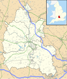
Thame is a market town and civil parish in Oxfordshire, about 13 miles (21 km) east of the city of Oxford and 10 miles (16 km) southwest of Aylesbury. It derives its name from the River Thame which flows along the north side of the town and forms part of the county border with Buckinghamshire. The parish includes the hamlet of Moreton south of the town. The 2011 Census recorded the parish's population as 11,561. Thame was founded in the Anglo-Saxon era and was in the kingdom of Wessex.

<span class="mw-page-title-main">Ickford</span> Human settlement in England

Ickford is a village and civil parish in the unitary authority area of Buckinghamshire, England. It is on the boundary with Oxfordshire, about 4 miles (6.4 km) west of the market town of Thame.

<span class="mw-page-title-main">Hollingbourne</span> Village near Maidstone, Kent, England

Hollingbourne is a village and civil parish in the borough of Maidstone in Kent, England. The parish is located on the southward slope of the North Downs to the east of the county town, Maidstone. The parish population is around 900 and has three conservation areas: Upper Street in the village centre and the outlying hamlets of Broad Street and Eyhorne Street.

<span class="mw-page-title-main">Bletchingley</span> Human settlement in England

Bletchingley is a village in Surrey, England. It is on the A25 road to the east of Redhill and to the west of Godstone, has a conservation area with medieval buildings and is mostly on a wide escarpment of the Greensand Ridge, which is followed by the Greensand Way.

<span class="mw-page-title-main">Watlington, Oxfordshire</span> Human settlement in England

Watlington is a small market town and civil parish about 7 miles (11 km) south of Thame in Oxfordshire, near the county's eastern edge and less than 2 miles (3 km) from its border with Buckinghamshire. The parish includes the hamlets of Christmas Common, Greenfield and Howe Hill, all of which are in the Chiltern Hills. The 2011 Census recorded the parish's population as 2,727.

<span class="mw-page-title-main">Beachamwell</span> Village and civil parish in the Breckland district of Norfolk, England

Beachamwell is a village and civil parish in the Breckland district of Norfolk, England about 5 miles (8.0 km) south west of Swaffham and 10 miles (16 km) east of Downham Market. It has four ancient churches, two of them in ruins. The former parish of Shingham has been annexed.

<span class="mw-page-title-main">Somerford Keynes</span> Village in Gloucestershire, England

Somerford Keynes is a village and civil parish in Gloucestershire, England, close to the River Thames and about 5 miles from its source. It lies on the boundary with Wiltshire, midway between Cirencester, Swindon and Malmesbury. The parish population at the 2011 census was 479. A 2019 estimate put it at 558.

<span class="mw-page-title-main">Chalgrove</span> Human settlement in England

Chalgrove is a village and civil parish in South Oxfordshire about 10 miles (16 km) southeast of Oxford. The parish includes the hamlet of Rofford and the former parish of Warpsgrove with which it merged in 1932. The 2011 Census recorded the parish population as 2,830. Chalgrove is the site of a small Civil War battle in 1643, the Battle of Chalgrove Field. The Parliamentarian John Hampden was wounded in the battle, and died of his wounds six days later.

<span class="mw-page-title-main">Woodeaton</span> Human settlement in England

Woodeaton or Wood Eaton is a village and civil parish about 4 miles (6.4 km) northeast of Oxford, England. It also has a special needs school called Woodeaton Manor School.

<span class="mw-page-title-main">Warborough</span> Village in Oxfordshire, England

Warborough is a village and civil parish in South Oxfordshire, about 2.5 miles (4 km) north of Wallingford and about 9 miles (14 km) south of Oxford. The parish also includes the hamlet of Shillingford, south of Warborough beside the River Thames.

<span class="mw-page-title-main">Pyrton</span> Village in Oxfordshire, England

Pyrton is a small village and large civil parish in Oxfordshire about 1 mile (1.6 km) north of the small town of Watlington and 5 miles (8 km) south of Thame. The 2011 Census recorded the parish's population as 227. The toponym is from the Old English meaning "pear-tree farm".

<span class="mw-page-title-main">Hangleton Manor Inn</span> Historic manor house in Hove, Sussex, England

Hangleton Manor Inn, the adjoining Old Manor House and associated buildings form a bar and restaurant complex in Hangleton, an ancient village which is part of the English city of Brighton and Hove. The manor house is the oldest secular building in the Hove part of the city; some 15th-century features remain, and there has been little change since the High Sheriff of Sussex rebuilt it in the mid-16th century. Local folklore asserts that a 17th-century dovecote in the grounds has been haunted since a monk placed a curse on it. The buildings that comprise the inn were acquired by Hangleton Manor Ltd in 1968, and converted to an inn under the Whitbread banner. The brewery company Hall & Woodhouse have owned and operated it since 2005. English Heritage has listed the complex at Grade II* for its architectural and historical importance, and the dovecote is listed separately at Grade II.

<span class="mw-page-title-main">Tolsey Museum</span> Municipal building in Burford, Oxfordshire, England

The Tolsey Museum is a local museum in the town of Burford, west Oxfordshire, England. It is located a Tudor style structure, known as The Tolsey, which was formerly the market hall and town hall of Burford. It is a Grade II* listed building.

<span class="mw-page-title-main">Ball Farm</span>

Ball Farm is the oldest surviving building in the village of Hankelow, near Audlem in Cheshire, England, and is thought to date from 1510. Most of its original timber frame was replaced by brick in the 19th century, but some close studding and small framing survives, as well as part of a mullioned-and-transomed window. Ball Farm was occupied by the Hassalls, a prominent local family, and might have once been used as a district court of justice. It is listed at grade II* by the Historic Buildings and Monuments Commission for England, the middle of the three grades, denoting "particularly important buildings of more than special interest".

<span class="mw-page-title-main">Thame Town Hall</span> Municipal building in Thame, Oxfordshire, England

Thame Town Hall is a municipal building in the High Street, Thame, Oxfordshire, England. The town hall, which is the meeting place of Thame Town Council, is a Grade II listed building.

<span class="mw-page-title-main">Woodstock Town Hall</span> Municipal building in Woodstock, Oxfordshire, England

Woodstock Town Hall is a municipal building in the Market Place in Woodstock, Oxfordshire, England. The building, which is used as a community events venue, is a Grade II listed building.

<span class="mw-page-title-main">Bampton Town Hall</span> Municipal building in Bampton, Oxfordshire, England

Bampton Town Hall is a municipal building in the Market Square in Bampton, Oxfordshire, England. The building, which is primarily used as an arts centre, is a Grade II listed building.

<span class="mw-page-title-main">Norton, Herefordshire</span> Human settlement in England

Norton is a civil parish in north-east Herefordshire, England, and is approximately 14 miles (23 km) north-east from the city and county town of Hereford. The closest town is Bromyard, conjoined to the parish at the south-west. The parish includes the elevated public open common land of Bromyard Downs.

<span class="mw-page-title-main">Edvin Loach and Saltmarshe</span> Human settlement in England

Edvin Loach and Saltmarshe is a civil parish in north-east Herefordshire, England, and is approximately 15 miles (24 km) north-east from the city and county town of Hereford. The nearest town is Bromyard, 2.5 miles (4 km) to the south-west. Within the parish is a George Gilbert Scott built parish church in the virtually depopulated settlement of Edvin Loach, and the repurposed site of the demolished Saltmarshe Castle.

<span class="mw-page-title-main">Malmesbury Town Hall</span> Municipal building in Malmesbury, Wiltshire, England

Malmesbury Town Hall is a municipal building in Cross Hayes in Malmesbury, Wiltshire, England. The structure, which is the meeting place of Malmesbury Town Council and the home of the Athelstan Museum, is a Grade II listed building.

References

  1. 1 2 Historic England. "Town Hall (1369012)". National Heritage List for England . Retrieved 1 April 2022.
  2. 1 2 3 4 5 Lobel, Mary D. (1964). "'Parishes: Watlington', in A History of the County of Oxford: Volume 8, Lewknor and Pyrton Hundreds". London: British History Online. pp. 210–252. Retrieved 1 April 2022.
  3. "Watlington Neighbourhood Development Plan" (PDF). South Oxfordshire Council. 1 August 2018. p. 16. Retrieved 1 April 2022.
  4. Sherwood, Jennifer; Pevsner, Nikolaus (1974). Oxfordshire (Buildings of England Series). Yale University Press. p. 830. ISBN   978-0300096392.
  5. "Welcome". Pishill with Stonor Parish Council. Retrieved 1 April 2022.
  6. "Venue Hire". Watlington Parish Council. Retrieved 1 April 2022.
  7. "History". Watlington Town Hall. Retrieved 1 April 2022.
  8. "Watlington: a small classic town". Rated Trips. Retrieved 1 April 2022.
  9. A Walk to Shirburn Castle. Vol. 1. Journal of the British Archaeological Association. 1895. p. 295.
  10. "Watlington Women's Institute". Watlington Parish News. 1 January 2013. p. 19. Retrieved 1 April 2022.
  11. "Midsomer Murders Locations Walking Trail" (PDF). Watlington Business Association. p. 3. Retrieved 1 April 2022.