
Miesville Ravine Park Reserve is a Dakota County park near the town of Miesville, Minnesota, United States. It preserves over 1,600 acres (6 km2) of biologically diverse land in the Cannon River valley. Most of the park is wooded with mature oak, maple, cottonwood, willow, red cedar, and white pine. A trout stream, Trout Brook, is located in the reserve.

The Whitewater River is a 16.6-mile-long (26.7 km) tributary of the Upper Mississippi River which flows through the Driftless Area of Minnesota, reaching its mouth in Wabasha County at the community of Weaver opposite Buffalo, Wisconsin. The nearest towns are Altura, Saint Charles, and Elba. The region hosts endangered native dry oak savannas, semiforested areas that seem to have been dependent on fire for their well-being.

Hay Creek is a small trout stream in southeastern Minnesota. It has its headwaters west of Goodhue and empties into the Mississippi River just to the north of Red Wing. It runs 25.1 miles (40.4 km). Hay Creek was named for the hay meadows near its banks. A railroad once ran along Hay Creek from the claybanks near Goodhue to the pottery and stoneware factories in Red Wing, which also made use of the water from the creek. The railroad was torn up in 1937, but traces such as trestle pilings remain.

The Caribou River is a 15.0-mile-long (24.1 km) river in northern Minnesota, the United States. It rises in a swamp about .6 miles (1 km) south of Morris Lake and two miles (3.2 km) east of Echo Lake, near the Lake/Cook County line, at an altitude about 1620 feet above sea level. It descends some 1,020 feet in elevation as it flows south to its mouth at Lake Superior, also near the eastern border of Lake County.

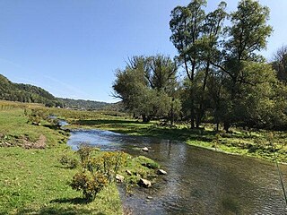
The Little Cannon River is a 30.6-mile-long (49.2 km) river of Minnesota in the United States. It flows into the Cannon River at the city of Cannon Falls. A section of the Little Cannon River south of Sogn, Minnesota is a designated trout stream by the Minnesota Department of Natural Resources.

The Poplar River is a river in northeastern Minnesota that drains into Lake Superior.
Winnebago Creek is a 23.6-mile-long (38.0 km) tributary of the Mississippi River in southeastern Minnesota. Winnebago Creek was named after the Winnebago Indians.

Mountain Creek is a 20.9-mile-long (33.6 km) tributary of Yellow Breeches Creek in Cumberland County, Pennsylvania.

Lewis is an unincorporated census-designated place in the town of Clam Falls, Polk County, Wisconsin, United States. Lewis is located on Wisconsin Highway 35 4.5 miles (7.2 km) northeast of Frederic. As of the 2010 census, its population is 164.
Brown's Creek is a 9.7-mile-long (15.6 km) stream which originates about 5.5 miles northwest of the city of Stillwater and flows south for about half its length then east to its confluence with the St. Croix River just north of Stillwater in Washington County, Minnesota, United States. It is one of few creeks in the Minneapolis – Saint Paul "Twin Cities" metropolitan area that supports a fishable trout population.
Money Creek is a stream in Houston and Winona counties, in the U.S. state of Minnesota. It is a tributary of the Root River. Money Creek was so named when a passerby's money blew into the creek and was lost.
Rush Creek is a stream in Fillmore and Winona counties, in the U.S. state of Minnesota. It is a tributary of the Root River, which it joins in Rushford, Minnesota.
Canfield Creek is a stream in Fillmore County, located in the U.S. state of Minnesota.
Camp Creek is a stream in Fillmore County, in the U.S. state of Minnesota. It is a tributary of the South Branch Root River. Camp Creek was named from the fact pioneer settlers camped upon its banks.
Wisel Creek is a stream in Fillmore County, in the U.S. state of Minnesota.
Belle Creek is a trout stream in Goodhue County, in the U.S. state of Minnesota. It is a tributary of the Cannon River.
Crooked Creek is a stream in Houston County, in the U.S. state of Minnesota. Crooked Creek was so named on account of its irregular course.
Badger Creek is a stream in Houston County, in the U.S. state of Minnesota. It is a tributary of the South Fork Root River, which it meets east of Houston, Minnesota. Badger Creek was named for the badgers once common in the area.
Pine Creek is a stream in Fillmore and Winona counties, in the U.S. state of Minnesota. It is a tributary of the Rush Creek, which is a tributary of the Root River. It joins the Rush Creek in the extreme north of Rushford, Minnesota. Tributaries of Pine Creek are Cooledge Creek and Hemmingway Creek.
