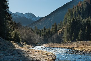
The valley, through which the Wattenbach stream flows, is incised deeply into the quartz-phyllite rock of the Tux Prealps. The two dispersed settlements of Wattenberg and Vögelsberg (in the municipality of Wattens) sprawl across the outer part of the valley. At the head of the valley is the Wattentaler Lizum and its military training area of Lizum Walchen which is run by the Austrian Armed Forces. The Wattentaler Lizum lies entirely on the territory of Wattenberg.
The Wattental produces a high level of water power thanks to its large catchment area which is why internationally successful firms such as Swarovski, and Wattenspapier have been established in the village of Wattens by the River Inn. The Wattental was and is therefore the reason behind the economic boom of the market village of Wattens which has made it one of the wealthiest municipalities in Austria.
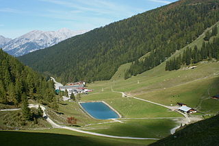
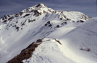
The valley is a popular recreation area. The summits of the Rotwandspitze, Hirzer and Hahneburger have outstanding views and can be climbed from bases in the valley. In the upper part of the valley (Mölsberg) access is limited by the military training area. On the first Sunday after the Assumption a service, the Mölsberg Mass (Mölsbergmesse) takes place at the summit cross of the Mölsberg in the middle of the Wattentaler Lizum, which is a memorial service to those from the valley who fell in the two world wars. On that day the training area is opened to private vehicles; normally it is out-of-bounds.
At the head of the valley is a small lake, the Mölssee.
Austria is a predominantly mountainous country in Central Europe, approximately between Germany, Italy and Hungary. It has a total area of 83,871 square kilometres (32,383 sq mi).
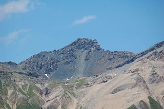
The Tux Alps or Tux Prealps are a sub-group of the Austrian Central Alps, which in turn form part of the Eastern Alps within Central Europe. They are located entirely within the Austrian federal state of Tyrol. The Tux Alps are one of three mountain ranges that form an Alpine backdrop to the city of Innsbruck. Their highest peak is the Lizumer Reckner, 2,886 m (AA), which rises between the glen of Wattentaler Lizum and the valley of the Navisbach. Their name is derived from the village of Tux which is tucked away in a side valley of the Zillertal.
The Bezirk Innsbruck-Land is an administrative district (Bezirk) in Tyrol, Austria. It encloses the Statutarstadt Innsbruck, and borders Bavaria (Germany) in the north, the district Schwaz in the east, South Tyrol in Italy to the south, and the district of Imst in the west.
The Ziller Valley is a valley in Tyrol, Austria that is drained by the Ziller River. It is the widest valley south of the Inn Valley and lends its name to the Zillertal Alps, the strongly glaciated section of the Alps in which it lies. The Tux Alps lie to its west, while the lower grass peaks of the Kitzbühel Alps are found to the east.
Wattens is a market town of the Innsbruck-Land District in the Austrian state of Tyrol. It is chiefly known as home of the Swarovski crystal glass company.
Absam is a municipality in the Innsbruck-Land District, Tyrol (Austria) situated at an altitude of 632 m, which had an area of 51.92 km2 and 6,776 inhabitants as January 2015.
The Wattenbach or Wattenerbach is a river of Tyrol, Austria, a tributary of the Inn.
Lake Moels is a lake of Tyrol, Austria.
Tux is a municipality in the Schwaz district in the Austrian state of Tyrol.
Terfens is a municipality in the Schwaz district with 2116 inhabitants in the Austrian state of Tyrol. It is located about 20 km northeast of Innsbruck in the Lower Inn Valley.
The Lower Inn Valley Railway is a two-track, electrified railway line that is one of the major lines of the Austrian railways. It was originally opened as the k.k. Nordtiroler Staatsbahn. It begins at the German border near the Austrian city of Kufstein as a continuation of the Rosenheim–Kufstein line and runs in a generally south-westerly direction through Tyrol along the Inn valley to Innsbruck. The line is part of the Line 1 of Trans-European Transport Networks (TEN-T). The line is owned and operated by Austrian Federal Railways (ÖBB).
The Innsbruck bypass is a 14.853-kilometre (9.229 mi)-long double-track electrified main line of the Austrian railways. It connects the Lower Inn Valley railway with the Brenner railway, bypassing Innsbruck. It was opened on 29 May 1994. The line is at a major part of the rail freight network of Austrian Federal Railways (ÖBB).
The New Lower Inn Valley railway is a partially completed double-track high-speed main line of the Austrian railways. It connects the Brenner railway at Innsbruck and the Innsbruck bypass with the line to Kufstein, connecting with Germany, Salzburg, and eastern Austria. It forms a part of the core of the network of Austrian Federal Railways (ÖBB). The bypass is part of Line 1 of the Trans-European Transport Networks (TEN-T). The first section (Kundl–Baumkirchen), which is designed for speeds up to 220 km/h (140 mph), was opened on 26 November 2012. Since the timetable change on 9 December 2012, it relieves the existing Lower Inn Valley railway between Wörgl and Baumkirchen with trains able to operate at up to 250 km/h (160 mph). In the future, these and other construction projects are expected to reduce travel time on the Munich–Innsbruck route from 1:50 to 0:55 and on the Munich–Verona route from 5:20 to 2:20. The cost of the project amounted to €2.358 billion.
Axamer Lizum is a village and ski resort in Austria, located southwest of Innsbruck in the state of Tyrol. At the 1964 Winter Olympics, it hosted five of the six alpine skiing events: women's downhill, and men's and women's slalom and giant slalom. Men's downhill was held at Patscherkofel. Twelve years later in 1976, it hosted exactly the same alpine skiing events.
The Alpbachtal is a valley in Tyrol, Austria. It is a side valley of the Inn valley.
The Wattentaler Lizum is the name of the head of the Wattental valley which branches off the lower Inn valley near Wattens. Lizum means "alpine pasture at the head of the valley" in Tyrolese. The Wattentaler Lizum lies at the eastern end of the valley in the municipality of Wattenberg.
The Lizumer Reckner is, at 2,886 m above sea level (AA), the highest mountain in the Tux Alps in the Austrian state of Tyrol.
The Rastkogel is a 2,762 metre high, pyramidal, mountain on the main crest of the Tux Alps in the Austrian federal state of Tyrol.
The Geier is, at 2,857 m above sea level (AA), the second highest mountain in the Tux Alps in the Austrian state of Tyrol.
The Lizumer Hütte is an Alpine club hut of the Hall in Tirol section of the Austrian Alpine Club in the Tux Alps in the Austrian state of Tyrol. The hut is located in the rear Wattental in the middle of the extensive ski touring and hiking area of the Wattentaler Lizum. Due to its location and size, the hut is also used for a wide variety of alpine courses and seminars.
This page is based on this Wikipedia article Text is available under the CC BY-SA 4.0 license; additional terms may apply. Images, videos and audio are available under their respective licenses.