Wattens is a market town of the Innsbruck-Land District in the Austrian state of Tyrol. It is chiefly known as home of the Swarovski crystal glass company.

Fritzens is a municipality in the district Innsbruck country in Tyrol (Austria). It lies 16 km east of Innsbruck on the left side of the Inn River. The Iron Age Fritzens-Sanzeno culture is named for archaeological finds from the village.
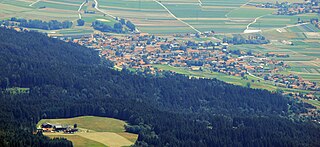
Terfens is a municipality in the Schwaz district with 2116 inhabitants in the Austrian state of Tyrol. It is located about 20 km northeast of Innsbruck in the Lower Inn Valley.

Kolsass is a municipality in the district Innsbruck-Land in the Austrian state of Tyrol located about 17 km east of Innsbruck. The location was first mentioned as „Quolesazz or Cholsasz" in 1050.

Kolsassberg is a municipality in the district Innsbruck-Land in the Austrian state of Tyrol located about 19 km east of Innsbruck and 2 km above Kolsass. The location was founded around 1196.

Mutters is a municipality in the Innsbruck-Land district in the Austrian state of Tyrol. It is located 4.70 km (3 mi) south of Innsbruck. The village was first mentioned in 1100 but settlement already began app. 3000 years ago. Mutters received connection with Innsbruck thanks to the Stubaitalbahn in 1904.
Oberhofen im Inntal is a municipality in the western district of Innsbruck-Land in the Austrian state of Tyrol located 21 km west of Innsbruck and 2.6 km east of Telfs. Once a part of Pfaffenhofen it became its own municipality in 1786.

Pettnau is a municipality in the district of Innsbruck-Land in the Austrian state of Tyrol located 16.7 km west of Innsbruck north of the Inn River between Telfs and Zirl. It has seven parts and was founded around 1291.

Pfaffenhofen is a municipality in the district of Innsbruck-Land in the Austrian state of Tyrol located 22 km west of Innsbruck and 1.7 km south of Telfs. The village was mentioned in documents in 1197 for the first time.

Wildermieming is a municipality in the district of Innsbruck-Land in the Austrian state of Tyrol located 40 km west of Innsbruck and 4 km west of Telfs. The village was separated from Mieming which belongs to Imst (district) in 1833 and was incorporated into Innsbruck-Land in 1925.
Volders is a municipality in the district of Innsbruck-Land in the Austrian state of Tyrol located 12 km east of Innsbruck on the southern side of the Inn River.

Unterperfuss is a municipality in the district of Innsbruck-Land in the Austrian state of Tyrol located 15 km west of Innsbruck and is one of the smallest villages of Tyrol. The area is restricted in the north by the Inn River and in the east by the Melach River. Unterperfuss has many facilities for horse-riding.

Tulfes is a municipality in the district of Innsbruck-Land in the Austrian state of Tyrol, located 12 km east of Innsbruck and 6 km above Hall in Tirol. The village was mentioned as “Tellevo” for the first time in 1240. Main source of income is tourism. Tulfes became a popular area of settlement due to the cities of Innsbruck and Hall.

Trins is a municipality in the district of Innsbruck-Land in the Austrian state of Tyrol located 20.3 km south of Innsbruck on the Gschnitzbach. The village was mentioned for the first time in 1030, as “Trunnes”. Formerly a part of the village Gschnitz, Trins became a separate municipality in 1811.
Thaur is a municipality in the district of Innsbruck-Land in the Austrian state of Tyrol located 5 km east of Innsbruck between Rum, Austria and Hall in Tirol.
Schönberg im Stubaital is a municipality in the district of Innsbruck-Land, Tyrol, Austria. It is 9 km (5.6 mi) south of Innsbruck at the entrance of the Stubaital. The village was mentioned as “Schönenberge” for the first time in 1180.

Schmirn is a municipality in the District Innsbruck-Land in the Austrian state of Tyrol.

Reith bei Seefeld is a municipality in the district of Innsbruck-Land in the Austrian state of Tyrol located 12.3 km northwest of Innsbruck and 3 km south of Seefeld in Tirol.

Polling in Tirol is a municipality in the district of Innsbruck-Land in the Austrian state of Tyrol located 17 km west of Innsbruck and 7 km before Telfs. The location was mentioned as “Pollinga” in 763 for the first time.

Mils is a municipality in the district Innsbruck-Land of Tyrol, Austria. It is located 12 km east of Innsbruck. The area is restricted by the Weißenbach in the west and the Inn in the south. The location was mentioned in documents in 930 for the first time. In the last 40 years Mils grew enormously thanks to its sunny location.