
Wattens is a market town of the Innsbruck-Land District in the Austrian state of Tyrol. It is chiefly known as home of the Swarovski crystal glass company.

Flaurling is a municipality in the district Innsbruck country in Tyrol (Austria). It lies in the Inn valley between Innsbruck and Telfs south of the Inn River.
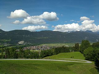
Terfens is a municipality in the Schwaz district with 2116 inhabitants in the Austrian state of Tyrol. It is located about 20 km northeast of Innsbruck in the Lower Inn Valley.

Grinzens is a municipality in the Austrian state of Tyrol in the district of Innsbruck-Land. As of January 2015, its population is 1414. It lies southwest of the city of Innsbruck at an elevation of 945 m.

Kolsass is a municipality in the district Innsbruck-Land in the Austrian state of Tyrol located about 17 km east of Innsbruck. The location was first mentioned as „Quolesazz or Cholsasz" in 1050.

Kolsassberg is a municipality in the district Innsbruck-Land in the Austrian state of Tyrol located about 19 km east of Innsbruck and 2 km above Kolsass. The location was founded around 1196.

Mutters is a municipality in the Innsbruck-Land district in the Austrian state of Tyrol. It is located 4.70 km (3 mi) south of Innsbruck. The village was first mentioned in 1100 but settlement already began app. 3000 years ago. Mutters received connection with Innsbruck thanks to the Stubaitalbahn in 1904.

Natters is a municipality in the district Innsbruck-Land in the Austrian state of Tyrol located 3.5 km south of Innsbruck. The village was mentioned in documents around 1151 for the first time. Natters as well as Mutters received connection with Innsbruck thanks to the Stubaitalbahn in 1904. It has 1918 inhabitants and an own hospital. The popular Natterer See is a treasure for tourists in summer.

Navis is a municipality in the district Innsbruck-Land in the Austrian state of Tyrol located 19 km southeast of Innsbruck in a valley with the same name which is a side valley of the Wipptal. The extensive territory of this municipality runs from the Sill up to the 2,359 m high Klammjoch saddle and the 2,886 m high Lizumer Reckner in the Tux Alps. The village is provided with fresh drinking water thanks to the clean Navisbach. The origin of the village name is unknown but settlement began at the end of the 13th century. Copper and silver were found in the 15th and 16th century.
Oberhofen im Inntal is a municipality in the western district of Innsbruck-Land in the Austrian state of Tyrol located 21 km west of Innsbruck and 2.6 km east of Telfs. Once a part of Pfaffenhofen it became its own municipality in 1786.

Wildermieming is a municipality in the district of Innsbruck-Land in the Austrian state of Tyrol located 40 km west of Innsbruck and 4 km west of Telfs. The village was separated from Mieming which belongs to Imst (district) in 1833 and was incorporated into Innsbruck-Land in 1925.
Wattenberg is a municipality in the district of Innsbruck-Land in the Austrian state of Tyrol located 15 km east of Innsbruck and 2.50 km above the Swarovski crystal town Wattens.

Tulfes is a municipality in the district of Innsbruck-Land in the Austrian state of Tyrol, located 12 km east of Innsbruck and 6 km above Hall in Tirol. The village was mentioned as “Tellevo” for the first time in 1240. Main source of income is tourism. Tulfes became a popular area of settlement due to the cities of Innsbruck and Hall.

Trins is a municipality in the district of Innsbruck-Land in the Austrian state of Tyrol located 20.3 km south of Innsbruck on the Gschnitzbach. The village was mentioned for the first time in 1030, as “Trunnes”. Formerly a part of the village Gschnitz, Trins became a separate municipality in 1811.
Thaur is a municipality in the district of Innsbruck-Land in the Austrian state of Tyrol located 5 km east of Innsbruck between Rum, Austria and Hall in Tirol.

Telfs is a market town in the district of Innsbruck-Land in the Austrian state of Tyrol, 27 kilometres west of Innsbruck. It is the third largest municipality in Tyrol. Telfs received its status in 1908 and maintains its own district court.
Schönberg im Stubaital is a municipality in the district of Innsbruck-Land, Tyrol, Austria. It is 9 km (5.6 mi) south of Innsbruck at the entrance of the Stubaital. The village was mentioned as “Schönenberge” for the first time in 1180.

Scharnitz is a municipality in the district of Innsbruck-Land in the Austrian state of Tyrol located 16.4 kilometres (10.2 mi) north of Innsbruck and 9 kilometres (5.6 mi) from Seefeld in Tirol on the German border. It is one of the largest municipalities and has 10 parts: Au, Eisack, Gießenbach, Inrain, Jägerviertel, Oberdorf, Schanz, Schießstand, Siedlung, Unterdorf. The village was founded in the early Middle Ages and was once an important commercial route between Germany and Italy. The main source of income is tourism, both in summer and winter. Scharnitz is the western entry point to the Hinterau valley, where the source of river Isar is located.

Reith bei Seefeld is a municipality in the district of Innsbruck-Land in the Austrian state of Tyrol located 12.3 km northwest of Innsbruck and 3 km south of Seefeld in Tirol.

Mils is a municipality in the district Innsbruck-Land of Tyrol, Austria. It is located 12 km east of Innsbruck. The area is restricted by the Weißenbach in the west and the Inn in the south. The location was mentioned in documents in 930 for the first time. In the last 40 years Mils grew enormously thanks to its sunny location.


