
The Tux Alps or Tux Prealps are a sub-group of the Austrian Central Alps, which in turn form part of the Eastern Alps within Central Europe. They are located entirely within the Austrian federal state of Tyrol. The Tux Alps are one of three mountain ranges that form an Alpine backdrop to the city of Innsbruck. Their highest peak is the Lizumer Reckner, 2,886 m (AA), which rises between the glen of Wattentaler Lizum and the valley of the Navisbach. Their name is derived from the village of Tux which is tucked away in a side valley of the Zillertal.
The Bezirk Innsbruck-Land is an administrative district (Bezirk) in Tyrol, Austria. It encloses the Statutarstadt Innsbruck, and borders Bavaria (Germany) in the north, the district Schwaz in the east, South Tyrol in Italy to the south, and the district of Imst in the west.

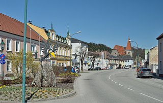
Wattens is a market town of the Innsbruck-Land District in the Austrian state of Tyrol. It is chiefly known as home of the Swarovski crystal glass company.

Ellbögen is a community in the district of Innsbruck Land and lies 12 km south of Innsbruck. It is a scattered village located on the eastern valley side of the Wipptal.

Tux is a municipality in the Schwaz district in the Austrian state of Tyrol.

Gries am Brenner, often referred to as simply Gries, is a municipality in the Wipptal in the southern district of Innsbruck-Land. The village consists of several hamlets.

Grinzens is a municipality in the Austrian state of Tyrol in the district of Innsbruck-Land. As of January 2015, its population is 1414. It lies southwest of the city of Innsbruck at an elevation of 945 m.
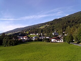
Gschnitz is a municipality with 415 inhabitants in the south of North Tyrol.

Matrei am Brenner is a small municipality in the southern part of the District Innsbruck-Land and is located approximately 17 km south of Innsbruck. Matrei has always been an important station for commerce. On 1 January 2022 the municipalities of Pfons and Mühlbachl were merged into Matrei. The village has 3,500 inhabitants, at 992 m. above sea level and the Sill river flows through it.

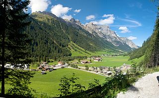
Navis is a municipality in the district Innsbruck-Land in the Austrian state of Tyrol located 19 km southeast of Innsbruck in a valley with the same name which is a side valley of the Wipptal. The extensive territory of this municipality runs from the Sill up to the 2,359 m high Klammjoch saddle and the 2,886 m high Lizumer Reckner in the Tux Alps. The village is provided with fresh drinking water thanks to the clean Navisbach. The origin of the village name is unknown but settlement began at the end of the 13th century. Copper and silver were found in the 15th and 16th century.

Neustift im Stubaital is a municipality in the district Innsbruck-Land in the Austrian state of Tyrol. It is the third largest municipality of Tyrol in area. It is a major tourist centre, with more than 1 million overnight stays per year.

Obernberg am Brenner is a municipality in the southern district of Innsbruck-Land in the Austrian state of Tirol.
Vals is a municipality in the southern Innsbruck-Land District in the Austrian state of Tyrol.

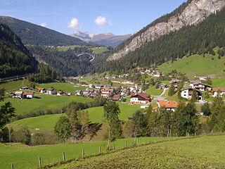
Trins is a municipality in the district of Innsbruck-Land in the Austrian state of Tyrol located 20.3 km south of Innsbruck on the Gschnitzbach. The village was mentioned for the first time in 1030, as “Trunnes”. Formerly a part of the village Gschnitz, Trins became a separate municipality in 1811.

Steinach am Brenner is a market town in the district of Innsbruck-Land in the Austrian state of Tyrol located south of Innsbruck in the Wipptal at the Sill River.
Pfons was a municipality in the district of Innsbruck-Land in the Austrian state of Tyrol located 13.7 km south of Innsbruck in the Wipptal at the Sill River. Although it is not exactly clear where the name of the village comes from, the location was first mentioned as “Phunzun” in 1030 and later as “Phanes” in 1177. Formerly a part of Matrei am Brenner, Pfons was declared as independent in 1811. On 1 January 2022 Pfons and Mühlbachl were merged into the municipality of Matrei am Brenner.

Scharnitz is a municipality in the district of Innsbruck-Land in the Austrian state of Tyrol located 16.4 kilometres (10.2 mi) north of Innsbruck and 9 kilometres (5.6 mi) from Seefeld in Tirol on the German border. It is one of the largest municipalities and has 10 parts: Au, Eisack, Gießenbach, Inrain, Jägerviertel, Oberdorf, Schanz, Schießstand, Siedlung, Unterdorf. The village was founded in the early Middle Ages and was once an important commercial route between Germany and Italy. The main source of income is tourism, both in summer and winter. Scharnitz is the western entry point to the Hinterau valley, where the source of river Isar is located.

Sankt Sigmund im Sellrain is a municipality in western Austria, in the district of Innsbruck-Land in the state of Tyrol located 23.3 kilometres (14.5 mi) southeast of Innsbruck, in the deepest part of the Sellrain Valley. It has a large area and the highest elevation. The main source of income is winter tourism.

Ranggen is a municipality in the district of Innsbruck-Land in the Austrian state of Tyrol located 12 km west of Innsbruck. The location was mentioned as “Fergen” in 1482 for the first time. Ranggen has 17 parts.
Rabenstein an der Pielach is a municipality in the district of Sankt Pölten-Land in Lower Austria, Austria.


