Neustift im Stubaital

Last updated

Neustift im Stubaital
Neustift von Serles.JPG
Wappen at neustift im stubaital.png
Austria adm location map.svg
Red pog.svg
Neustift im Stubaital
Location within Austria
Coordinates: 47°06′37″N11°18′21″E / 47.11028°N 11.30583°E / 47.11028; 11.30583 Coordinates: 47°06′37″N11°18′21″E / 47.11028°N 11.30583°E / 47.11028; 11.30583
Country Austria
State Tyrol
District Innsbruck Land
Government
   Mayor Peter Schönherr
Area
[1]
  Total249 km2 (96 sq mi)
Elevation
994 m (3,261 ft)
Population
 (2018-01-01) [2]
  Total4,747
  Density19/km2 (49/sq mi)
Time zone UTC+1 (CET)
  Summer (DST) UTC+2 (CEST)
Postal code
6167
Area code 05226
Vehicle registration IL
Website www.neustift.tirol.gv.at

Neustift im Stubaital is a municipality in the district Innsbruck-Land in the Austrian state of Tyrol. It is the third largest municipality of Tyrol in area. It is a major tourist centre, with more than 1 million overnight stays per year.

Contents

Geography

Neustift is located 25 kilometres (15 miles) south of Innsbruck in the Stubaital or Stubai Valley. This broad valley is one of the most scenic in Tyrol. At the entrance to the valley stand massive limestone formations. Around the upper valley, peaks of gneiss and granite rise above 3,000 metres (about 10,000 feet) to areas of permanent ice. Five glaciers covering 15 square kilometres (5.8 sq mi) form a large glacier ski area, the Stubai Glacier. Including the facilities here and in three other ski areas, the valley has 42 cable cars and ski lifts.

Neustift is connected to Innsbruck by a bus line operated by Innsbrucker Verkehrsbetriebe.

Neustift im Stubaital consists of the following sections and villages: Kampl, Neder, Dorf, Scheibe, Milders, Oberberg, Stackler, Lehner, Schaller, Krössbach, Neugasteig, Gasteig, Volderau, Ranalt, and Mutterberg.

The municipalities bordering on Neustift are Brenner, Fulpmes, Grinzens, Gschnitz, Längenfeld, Mühlbachl, Ratschings, Sankt Sigmund im Sellrain, Sellrain, Sölden, Telfes im Stubai, and Trins.

History

Origin

View of the parish church Neustift im Stubai Ortsbild.jpg
View of the parish church

Around 1000, the Stubaital was first mentioned in writing as Stupeia. By 1400, the district of Stubai was composed of five small communities: Telfes, Schönberg, Mieders, Fulpmes, and "im Tal" ("in the valley").

Although the name Neustift appears in records from the 14th century as "Niwenstift im tal ze Stubai", centuries passed before the modern name Neustift prevailed over im Tal as the name of the community. The inhabitants of Neustift are still known today as Tholer ("valley dwellers").

Place names in the region point to pre-Roman settlement. When Caesar Augustus and his legions pushed north in 15 BCE, the mountain people living here and their region were subjugated as the Roman province of Raetia. Subsequently, the Romans made an impact on the region through their administration and later through Christianization. Prehistoric finds from the early Bronze Age (c. 1800–1000 BCE) show that the valley was settled in ancient times. The many Rhaeto-Romance place names suggest that the German language did not prevail in the region until some time during the Middle Ages. These place names include the following:

During World War II, the Schutzstaffel (SS) had a mountaineering training centre in Neustift, where prisoners from the Dachau concentration camp were put to work.

Coat-of-arms

The emblem of the town consists of a red shield, with a central horizontal white band like the Austrian flag, and a crossbow with two central black arrows crossing each other. The crossbow is a reminiscent of the hunting trips of Emperor Maximilian to Oberbergtal.

Population

Historical population
YearPop.±%
18691,241    
18801,265+1.9%
18901,217−3.8%
19001,344+10.4%
19101,372+2.1%
19231,372+0.0%
19341,646+20.0%
19391,805+9.7%
19512,018+11.8%
19612,195+8.8%
19712,794+27.3%
19813,307+18.4%
19913,791+14.6%
20014,328+14.2%
20114,510+4.2%

Sights

St. George Church

Interior of the parish church Neustift 1.JPG
Interior of the parish church

Emperor Maximilian I hunted deer, chamois, and boar in the upper Stubaital. In 1505 he founded a chapel in Neustift, though the village did not receive its own priest until 1868. In 1516 the first church in Neustift was dedicated to Saint George by the bishop of Brixen. In 1772 this church fell victim to a fire. In 1768 construction of a new church had already begun, since the original church was already too small. Pastor Franz de Paula Penz was the builder of the impressive Neustift parish church. He was one of the most celebrated architects of the late baroque in Tyrol. In 1812 Neustift became an independent parish. Externally, St. George's Church, in the village centre, seems very plain. However, the interior is quite rich, decorated with frescos by well-known masters. The parish church is Tyrol's second-largest village church. The "glacier pastor" and co-founder of the Alpine Club, Franz Senn, is buried in the attractive church cemetery.

Related Research Articles

<span class="mw-page-title-main">Innsbruck</span> Capital city of Tyrol, Austria

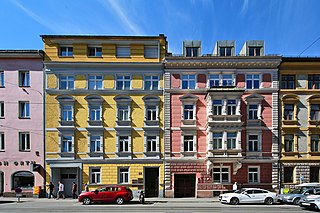
Innsbruck is the capital of Tyrol and the fifth-largest city in Austria. On the River Inn, at its junction with the Wipp Valley, which provides access to the Brenner Pass 30 km (18.6 mi) to the south, it had a population of 132,493 in 2018.

<span class="mw-page-title-main">Stubai Alps</span>

The Stubai Alps is a mountain range in the Central Eastern Alps of Europe. It derives its name from the Stubaital valley to its east and is located southwest of Innsbruck, Austria. Several peaks form the border between Austria and Italy. The range is bounded by the Inn River valley to the north; the Sill River valley (Wipptal) and the Brenner Pass to the east ; the Ötztal and Timmelsjoch to the west, and to the south by tributaries of the Passer River and Eisack.

<span class="mw-page-title-main">Stubaital</span>

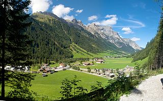
The Stubai Valley or Stubaital is an alpine valley in Tyrol, Austria. It is the central valley of the Stubai Alps. The river Ruetz flows through the valley.

<span class="mw-page-title-main">Serles</span> Mountain in Tyrol, Austria

Serles is a mountain of the Stubai Alps in the Austrian state of Tyrol, Austria, between the Stubai Valley and Wipptal, near the Italian border. Its nickname is Altar von Tirol, literally the Altar of Tyrol. It has several lower peaks, including Sonnenstein to the north.

<span class="mw-page-title-main">Fulpmes</span> Place in Tyrol, Austria

Fulpmes is a market town and a municipality in Stubaital, Tyrol, Austria. In 2015 it had a population of 4,250, of whom 14.5% did not have Austrian nationality. Fulpmes is the center of iron production in the area, and lies at the base of the Schlick 2000 ski area.

<span class="mw-page-title-main">Franz Senn Hut</span>

The Franz Senn Hut is a large and very popular Category I alpine hut in the Stubai Alps owned by the Austrian Alpine Club. It is a large, well-appointed hut, named after Franz Senn. Access is from Oberiss in the Oberbergtal off the Stubaital above Neustift.

<span class="mw-page-title-main">Innsbruck-Land District</span> District in Tyrol, Austria

The Bezirk Innsbruck-Land is an administrative district (Bezirk) in Tyrol, Austria. It encloses the Statutarstadt Innsbruck, and borders Bavaria (Germany) in the north, the district Schwaz in the east, South Tyrol in Italy to the south, and the district of Imst in the west.

<span class="mw-page-title-main">Telfes</span> Place in Tyrol, Austria

Telfes is a village in the district Innsbruck Land in the Austrian state of Tyrol. It is situated in the Stubaital 11 km south of Innsbruck.

<span class="mw-page-title-main">Ratschings</span> Comune in Trentino-Alto Adige/Südtirol, Italy

Ratschings is a comune (municipality) in South Tyrol in northern Italy, located about 45 kilometres (28 mi) north of the city of Bolzano, on the border with Austria.

<span class="mw-page-title-main">Stubaitalbahn</span> Interurban tram in Tyrol, Austria

The Stubaitalbahn is an 18.2 km (11.31 mi) long narrow gauge interurban tram from Innsbruck to Fulpmes in Tyrol, Austria. In the city of Innsbruck, it uses the local tramway tracks. At the Stubaital station, the branch line-rated part begins. The meter gauge track starts at Innsbruck's Main station, crosses the Wilten district, and passes the villages of Natters, Mutters, Kreith, and Telfes. Between the Stubaital station and Fulpmes, the railway is single-track, but at nine stations: Sonnenburgerhof, Hölltal, Mutters, Nockhofweg Muttereralmbahn, Feldeler, Kreith, Telfer Wiesen, Luimes, Telfes, there are passing loops where the train usually uses the left-hand track. The final station, Fulpmes, has three tracks and one depot.

<span class="mw-page-title-main">Inzing</span> Place in Tyrol, Austria

Inzing is a town in the Austrian Federal State Tyrol.

<span class="mw-page-title-main">Gries im Sellrain</span> Place in Tyrol, Austria

Gries im Sellrain is a municipality in the Sellrain Valley in the western district of Innsbruck-Land. The village lies in the valley and the Melach River flows through it.

<span class="mw-page-title-main">Gschnitz</span> Place in Tyrol, Austria

Gschnitz is a municipality with 415 inhabitants in the south of North Tyrol.

<span class="mw-page-title-main">Mieders</span> Place in Tyrol, Austria

Mieders is a municipality in the southern part of the district Innsbruck-Land in the Austrian state of Tyrol. It is located on the right side of the Stubaital 10.60 km south of Innsbruck.

<span class="mw-page-title-main">Mühlbachl</span> Place in Tyrol, Austria

Mühlbachl was a municipality in the district Innsbruck-Land located 15 km south of Innsbruck. Mühlbachl extended from the southern slopes of Schönberg im Stubaital along Matreiwald to Steinach and the Sill River flew through it. It had 1,349 inhabitants. On 1 January 2022 Mühlbachl and Pfons were merged into the municipality of Matrei am Brenner.

<span class="mw-page-title-main">Unterperfuss</span> Place in Tyrol, Austria

Unterperfuss is a municipality in the district of Innsbruck-Land in the Austrian state of Tyrol located 15 km west of Innsbruck and is one of the smallest villages of Tyrol. The area is restricted in the north by the Inn River and in the east by the Melach River. Unterperfuss has many facilities for horse-riding.

<span class="mw-page-title-main">Sellrain</span> Place in Tyrol, Austria

Sellrain is a municipality in the district of Innsbruck-Land in the Austrian state of Tyrol located 14.40 km southwest of Innsbruck in the Sellrain Valley. The Melach River and its tributary the Fotscherbach flow through it. Most people in the village are farmers and also have another job in the neighboring Innsbruck. There are two Catholic churches in the village St. Quirin and St. Anna. They are both over 300 years old.

<span class="mw-page-title-main">Sankt Sigmund im Sellrain</span> Place in Tyrol, Austria

Sankt Sigmund im Sellrain is a municipality in western Austria, in the district of Innsbruck-Land in the state of Tyrol located 23.3 kilometres (14.5 mi) southeast of Innsbruck, in the deepest part of the Sellrain Valley. It has a large area and the highest elevation. The main source of income is winter tourism.

<span class="mw-page-title-main">Kühtai</span> Village

Kühtai is a winter sports village in the Stubai Alps on the Kühtai Saddle between the Nedertal valley in the west and the Sellrain valley in the east. It is part of the municipality of Silz, in the district of Imst, in the Austrian state of Tyrol.

Stubai may mean:

References

  1. "Dauersiedlungsraum der Gemeinden Politischen Bezirke und Bundesländer - Gebietsstand 1.1.2018". Statistics Austria. Retrieved 10 March 2019.
  2. "Einwohnerzahl 1.1.2018 nach Gemeinden mit Status, Gebietsstand 1.1.2018". Statistics Austria. Retrieved 9 March 2019.