Stubaital

Last updated
Stubai Valley
Elferspitzenblick.jpg
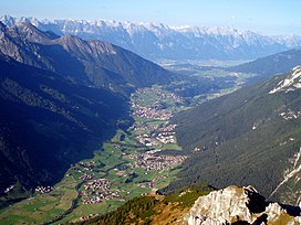
View from the Elfer valleywards
Floor elevation900–1,700 m (3,000–5,600 ft)
Length35 km (22 mi)
Naming
Native nameStubaital (German)
Geography
Location Tyrol, Austria
Coordinates 47°8′50″N11°20′49″E / 47.14722°N 11.34694°E / 47.14722; 11.34694
Mountain range Stubai Alps
River Ruetz
Stubaital and the Stubai Glacier in Tyrol, Austria Stubaier Gletscher Aussicht.jpg
Stubaital and the Stubai Glacier in Tyrol, Austria

The Stubai Valley or Stubaital is an alpine valley in Tyrol, Austria. It is the central valley of the Stubai Alps. The river Ruetz flows through the valley.

This 35-km long valley runs in northeastern direction from the main chain of the Alps to Schönberg im Stubaital, near Innsbruck. Below Fulpmes, the villages lie on terraces above the Ruetz on either side of the river. South of Neustift im Stubaital, the largest side valley Oberbergtal joins from the west. The ÖBB operates a 16-MW hydroelectric power plant in Fulpmes.

The following five municipalities lie in the valley: Schönberg im Stubaital, Mieders, Telfes, Fulpmes and Neustift im Stubaital. [1] Public transportation from Innsbruck into the valley is available via the Stubaital bus route or the Stubai Valley Railway, which runs from Innsbruck to Fulpmes.

At the end of the Stubaital valley the Stubai Glacier is used as a ski resort. [2]

Coordinates: 47°10′00″N11°19′00″E / 47.1667°N 11.3167°E / 47.1667; 11.3167

Related Research Articles

<span class="mw-page-title-main">Ötztal Alps</span>

The Ötztal Alps are a mountain range in the Central Eastern Alps, in the State of Tyrol in western Austria and the Province of South Tyrol in northern Italy.

<span class="mw-page-title-main">Serles</span> Mountain in Tyrol, Austria

Serles is a mountain of the Stubai Alps in the Austrian state of Tyrol, Austria, between the Stubai Valley and Wipptal, near the Italian border. Its nickname is Altar von Tirol, literally the Altar of Tyrol. It has several lower peaks, including Sonnenstein to the north.

<span class="mw-page-title-main">Fulpmes</span> Place in Tyrol, Austria

Fulpmes is a market town and a municipality in Stubaital, Tyrol, Austria. In 2015 it had a population of 4,250, of whom 14.5% did not have Austrian nationality. Fulpmes is the center of iron production in the area, and lies at the base of the Schlick 2000 ski area.

<span class="mw-page-title-main">Franz Senn Hut</span>

The Franz Senn Hut is a large and very popular Category I alpine hut in the Stubai Alps owned by the Austrian Alpine Club. It is a large, well-appointed hut, named after Franz Senn. Access is from Oberiss in the Oberbergtal off the Stubaital above Neustift.

<span class="mw-page-title-main">Sill (river)</span> River in Tyrol, Austria

The Sill is a 43-kilometre-long (27 mi) river in Tyrol, Austria. It is one of the larger tributaries of the Inn in Tyrol. It flows north through the Wipptal to Innsbruck. Its source lies east of the Brenner Pass. At the Sillzwickel - the name of the point where it meets the Inn at Innsbruck - there is a recreation area with cycling trails.

The Bezirk Imst is an administrative district (Bezirk) in Tyrol, Austria. It borders the district Reutte in the north, as well as sharing a small border with Bavaria (Germany). It borders the district Innsbruck-Land in the east, South Tyrol (Italy) in the south, and the district Landeck in the west.

<span class="mw-page-title-main">Innsbruck-Land District</span> District in Tyrol, Austria

The Bezirk Innsbruck-Land is an administrative district (Bezirk) in Tyrol, Austria. It encloses the Statutarstadt Innsbruck, and borders Bavaria (Germany) in the north, the district Schwaz in the east, South Tyrol in Italy to the south, and the district of Imst in the west.

<span class="mw-page-title-main">Telfes</span> Place in Tyrol, Austria

Telfes is a village in the district Innsbruck Land in the Austrian state of Tyrol. It is situated in the Stubaital 11 km south of Innsbruck.

<span class="mw-page-title-main">Ruetz (river)</span> River in Tyrol, Austria

The Ruetz is a river of Tyrol, Austria, a tributary of the Sill.

<span class="mw-page-title-main">Stubaitalbahn</span> Interurban tram in Tyrol, Austria

The Stubaitalbahn is an 18.2 km (11.31 mi) long narrow gauge interurban tram from Innsbruck to Fulpmes in Tyrol, Austria. In the city of Innsbruck, it uses the local tramway tracks. At the Stubaital station, the branch line-rated part begins. The meter gauge track starts at Innsbruck's Main station, crosses the Wilten district, and passes the villages of Natters, Mutters, Kreith, and Telfes. Between the Stubaital station and Fulpmes, the railway is single-track, but at nine stations: Sonnenburgerhof, Hölltal, Mutters, Nockhofweg Muttereralmbahn, Feldeler, Kreith, Telfer Wiesen, Luimes, Telfes, there are passing loops where the train usually uses the left-hand track. The final station, Fulpmes, has three tracks and one depot.

<span class="mw-page-title-main">Zuckerhütl</span>

The Zuckerhütl is a mountain in Tyrol, Austria. At 3,505 metres, it is the highest peak of the Stubai Alps and lies at the southern end of the Stubaital Valley.

<span class="mw-page-title-main">Mieders</span> Place in Tyrol, Austria

Mieders is a municipality in the southern part of the district Innsbruck-Land in the Austrian state of Tyrol. It is located on the right side of the Stubaital 10.60 km south of Innsbruck.

<span class="mw-page-title-main">Mühlbachl</span> Place in Tyrol, Austria

Mühlbachl was a municipality in the district Innsbruck-Land located 15 km south of Innsbruck. Mühlbachl extended from the southern slopes of Schönberg im Stubaital along Matreiwald to Steinach and the Sill River flew through it. It had 1,349 inhabitants. On 1 January 2022 Mühlbachl and Pfons were merged into the municipality of Matrei am Brenner.

<span class="mw-page-title-main">Neustift im Stubaital</span> Place in Tyrol, Austria

Neustift im Stubaital is a municipality in the district Innsbruck-Land in the Austrian state of Tyrol. It is the third largest municipality of Tyrol in area. It is a major tourist centre, with more than 1 million overnight stays per year.

<span class="mw-page-title-main">Brenner Autobahn</span>

The Brenner Autobahn refers to a major European truck route that connects Innsbruck in Austria to Verona in northern Italy.

<span class="mw-page-title-main">Tiroler MuseumsBahnen</span>

The Tyrolean Museum Railways or Tiroler MuseumsBahnen (TMB) is a railway society in Austria whose aim is the preservation and/or documentation of the historically important branch lines and their rolling stock in the state of Tyrol.

<span class="mw-page-title-main">Innsbruck Stubaital station</span> Railway station in Tyrol, Austria

Stubaital station was built in 1903 and, until 1983, was the terminus of the Stubai Valley Railway in Innsbruck. Since 1983 trains approaching from Fulpmes have been routed through the city of Innsbruck.

Stubai may mean:

<span class="mw-page-title-main">Mittenwald Railway</span> Railway line

The Mittenwald Railway, popularly known as the Karwendelbahn, is a railway line in the Alps in Austria and Germany. It connects Innsbruck via Seefeld and Mittenwald to Garmisch-Partenkirchen.

<span class="mw-page-title-main">Oberbergtal</span>

The Oberbergtal is the largest tributary valley of the Stubaital, branching north above Milders and curving south-west to the road-head at OberIss. 2 hours up the path is the Franz Senn Hut.

References

  1. "Stubai". Stubai.at. Retrieved 23 August 2021.
  2. "Summer in Stubai Hiking, biking and relaxing in Tyrol". Holidays in the Stubai Valley. Retrieved 23 August 2021.