
Fulpmes is a market town and a municipality in Stubaital, Tyrol, Austria. In 2015 it had a population of 4,250, of whom 14.5% did not have Austrian nationality. Fulpmes is the center of iron production in the area, and lies at the base of the Schlick 2000 ski area.

Wattens is a market town of the Innsbruck-Land District in the Austrian state of Tyrol. It is chiefly known as home of the Swarovski crystal glass company.
Frastanz is a market town in the district of Feldkirch in the westernmost Austrian state of Vorarlberg. In former times it was known for its production of tobacco.

Hatting is a municipality in the district Innsbruck-Land and is located 18 km west of the city of Innsbruck. The village was mentioned around 11th century for the first time.

Nenzing is a market town in the district of Bludenz in the Austrian state of Vorarlberg with a population of 6,225 (2022).

Inzing is a town in the Austrian Federal State of Tyrol.

Oberperfuss is a municipality in the district of Innsbruck-Land in the Austrian state of Tyrol located about 15 km (9.3 mi) west of Innsbruck at the entrance of the Sellrain Valley. It was mentioned in documents around 1083 for the first time.

Ellbögen is a community in the district of Innsbruck Land and lies 12 km south of Innsbruck. It is a scattered village located on the eastern valley side of the Wipptal.

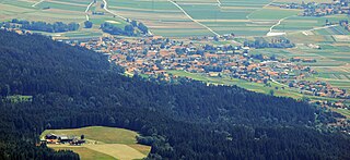
Flaurling is a municipality in the district Innsbruck country in Tyrol (Austria). It lies in the Inn valley between Innsbruck and Telfs south of the Inn River.

Pettnau is a municipality in the district of Innsbruck-Land in the Austrian state of Tyrol located 16.7 km west of Innsbruck north of the Inn River between Telfs and Zirl. It has seven parts and was founded around 1291.
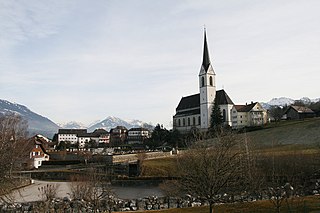
Wattenberg is a municipality in the district of Innsbruck-Land in the Austrian state of Tyrol located 15 km east of Innsbruck and 2.50 km above the Swarovski crystal town Wattens.
Völs is a market town in the district of Innsbruck-Land in the Austrian state of Tyrol, located at the western border of Innsbruck. It was mentioned for the first time in documents in 1188.

Unterperfuss is a municipality in the district of Innsbruck-Land in the Austrian state of Tyrol located 15 km west of Innsbruck and is one of the smallest villages of Tyrol. The area is restricted in the north by the Inn River and in the east by the Melach River. Unterperfuss has many facilities for horse-riding.
Thaur is a municipality in the district of Innsbruck-Land in the Austrian state of Tyrol located 5 km east of Innsbruck between Rum, Austria and Hall in Tirol.

Telfs is a market town in the district of Innsbruck-Land in the Austrian state of Tyrol, 27 kilometres west of Innsbruck. It is the third largest municipality in Tyrol. Telfs received its status in 1908 and maintains its own district court.

Sellrain is a municipality in the district of Innsbruck-Land in the Austrian state of Tyrol located 14.40 km (8.95 mi) southwest of Innsbruck in the Sellrain Valley. The River Melach and its tributary the Fotscherbach flow through it. Most inhabitants are farmers and also have another job in the neighboring Innsbruck. There are two Catholic churches in the village St. Quirin and St. Anna. They are both over 300 years old.

Sankt Sigmund im Sellrain is a municipality in western Austria, in the district of Innsbruck-Land in the state of Tyrol located 23.3 kilometres (14.5 mi) southeast of Innsbruck, in the deepest part of the Sellrain Valley. It has a large area and the highest elevation. The main source of income is winter tourism.

Rum is a market town located in the Austrian state of Tyrol on the eastern border of Innsbruck in the administrative district of Innsbruck-Land.

Ranggen is a municipality in the district of Innsbruck-Land in the Austrian state of Tyrol located 12 km west of Innsbruck. The location was mentioned as “Fergen” in 1482 for the first time. Ranggen has 17 parts.

Lermoos is a municipality in the district of Reutte in the Austrian state of Tyrol.


