
Huancavelica is a department in Peru with an area of 22,131.47 km2 (8,545.01 sq mi) and a population of 347,639. The capital is the city Huancavelica. The region is bordered by the departments of Lima and Ica in the west, Junín in the north, and Ayacucho in the east.

Junín is a region in the central highlands and westernmost Peruvian Amazon. Its capital is Huancayo.

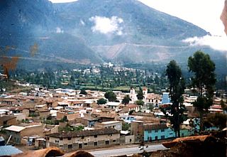
The Tarma Province is a Peruvian province, making up one of the nine provinces that conform the Junín Region. To the north it borders with the Junín Province, the east with the Chanchamayo Province, the south with the Jauja Province and the west with the Yauli Province.
Acobamba or Aqupampa is a district in the middle of Tarma Province in Peru. It is bordered by districts of Tarma, La Unión and Palcamayo on the west, Huasahuasi District on the north, districts of Palca and Tapo on the east, and districts of Tapo and Tarma on the south.
Yaru Quechua is a dialect cluster of Quechua, spoken in the Peruvian provinces of Pasco and Daniel Alcides Carrión and neighboring areas in northern Junín and Lima department.
Waskhaqucha or Wask'aqucha may refer to:

Tarmatambo or Tarmatampu is an archaeological site in the Junín Region in Peru. It is located in the Tarma Province, Tarma District, in the community of the same name. The site was declared a National Cultural Heritage by Resolución Directoral Nacional No. 040/INC on January 29, 2002.
Qanchisqucha is a group of seven lakes in Peru located in the Junín Region, Tarma Province, San Pedro de Cajas District. The lakes lie east of the mountain Urqunpunta (Orccompunta), at the foot of the mountain named Qanchisqucha.
Qanchisqucha may refer to:
Qanchisqucha is a group of seven lakes in Peru. They are situated in the Junín Region, Tarma Province, Huasahuasi District.

Yana Urqu is a mountain in the Andes of Peru which reaches a height of approximately 4,200 m (13,800 ft). It lies in the Junín Region, Tarma Province, Acobamba District, northeast of Acobamba.
Rumi Pukyu is a mountain in the Andes of Peru which reaches a height of approximately 4,200 m (13,800 ft). It lies in the Junín Region, Tarma Province, on the border of the districts of Acobamba and Huasahuasi. Rumi Pukyu lies on the left bank of the Pallqamayu, north of the village of Acobamba.
Warmi Sinqa is a mountain in the Andes of Peru which reaches a height of approximately 4,000 m (13,000 ft). It lies in the Junín Region, Tarma Province, Tarma District.
Tinya Warkhu is a mountain in the Andes of Peru which reaches a height of approximately 4,400 m (14,400 ft). It lies in the Junín Region, Tarma Province, Cajas District. Tinya Warkhu is also the name of the village west of the mountain.
Pukara Punta is a mountain in the Andes of Peru which reaches a height of approximately 4,400 m (14,400 ft). It lies in the Junín Region, Tarma Province, on the border of the districts of Palcamayo and Cajas.
Uchku Mach'ay is a mountain in the Andes of Peru which reaches a height of approximately 4,000 m (13,000 ft). It lies in the Junín Region, Tarma Province, Tarma District.
Kuntur Sinqa is a mountain in the Andes of Peru which reaches a height of approximately 4,000 m (13,000 ft). It lies in the Junín Region, Tarma Province, Tarma District.
Kuntur Wayin is a mountain in the Andes of Peru which reaches a height of approximately 4,400 m (14,400 ft). It lies in the Junín Region, Tarma Province, Tarma District.
Kuntur Punta is a mountain in the Andes of Peru which reaches a height of approximately 4,400 m (14,400 ft). It is located in the Junín Region, Tarma Province, Cajas District.
Hatun Raqra is a mountain in the Andes of Peru which reaches a height of approximately 4,200 m (13,800 ft). It is located in the Junín Region, Tarma Province, Cajas District.


