This article needs additional citations for verification .(April 2009) |
A weather hole is a location that receives calmer weather than the surrounding area. It is an area thunderstorms often miss, or near which approaching storms often dissipate.
This article needs additional citations for verification .(April 2009) |
A weather hole is a location that receives calmer weather than the surrounding area. It is an area thunderstorms often miss, or near which approaching storms often dissipate.
A 2005 study entitled "Do Meteorologists Suppress Thunderstorms?: Radar-Derived Statistics and the Behavior of Moist Convection" examined 28 target cities and random control points in the U.S. They were compared to their surroundings in order to determine whether these target points were weather holes or the opposite, hot spots. A determination was made by measuring and comparing the convective echoes of the target points with the surrounding area. Only one target was classified as a weather hole, and one was classified as a hot spot. Most selected targets experienced convective echoes as often as their surrounding areas. [1]
According to the a study's authors, the "results suggest that meteorologists are unnecessarily cranky about the frequency of storms in their hometowns." [2] It has been suggested that Grand Forks, ND is a weather hole. [3]

A tornado is a violently rotating column of air that is in contact with both the surface of the Earth and a cumulonimbus cloud or, in rare cases, the base of a cumulus cloud. It is often referred to as a twister, whirlwind or cyclone, although the word cyclone is used in meteorology to name a weather system with a low-pressure area in the center around which, from an observer looking down toward the surface of the Earth, winds blow counterclockwise in the Northern Hemisphere and clockwise in the Southern. Tornadoes come in many shapes and sizes, and they are often visible in the form of a condensation funnel originating from the base of a cumulonimbus cloud, with a cloud of rotating debris and dust beneath it. Most tornadoes have wind speeds less than 180 kilometers per hour, are about 80 meters across, and travel several kilometers before dissipating. The most extreme tornadoes can attain wind speeds of more than 480 kilometers per hour (300 mph), are more than 3 kilometers (2 mi) in diameter, and stay on the ground for more than 100 km (62 mi).

A thunderstorm, also known as an electrical storm or a lightning storm, is a storm characterized by the presence of lightning and its acoustic effect on the Earth's atmosphere, known as thunder. Relatively weak thunderstorms are sometimes called thundershowers. Thunderstorms occur in a type of cloud known as a cumulonimbus. They are usually accompanied by strong winds and often produce heavy rain and sometimes snow, sleet, or hail, but some thunderstorms produce little precipitation or no precipitation at all. Thunderstorms may line up in a series or become a rainband, known as a squall line. Strong or severe thunderstorms include some of the most dangerous weather phenomena, including large hail, strong winds, and tornadoes. Some of the most persistent severe thunderstorms, known as supercells, rotate as do cyclones. While most thunderstorms move with the mean wind flow through the layer of the troposphere that they occupy, vertical wind shear sometimes causes a deviation in their course at a right angle to the wind shear direction.

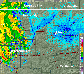
Weather radar, also called weather surveillance radar (WSR) and Doppler weather radar, is a type of radar used to locate precipitation, calculate its motion, and estimate its type. Modern weather radars are mostly pulse-Doppler radars, capable of detecting the motion of rain droplets in addition to the intensity of the precipitation. Both types of data can be analyzed to determine the structure of storms and their potential to cause severe weather.

A derecho is a widespread, long-lived, straight-line wind storm that is associated with a fast-moving group of severe thunderstorms known as a mesoscale convective system.

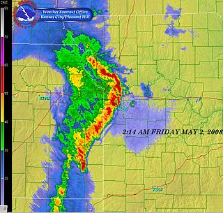
A hook echo is a pendant or hook-shaped weather radar signature as part of some supercell thunderstorms. It is found in the lower portions of a storm as air and precipitation flow into a mesocyclone, resulting in a curved feature of reflectivity. The echo is produced by rain, hail, or even debris being wrapped around the supercell. It is one of the classic hallmarks of tornado-producing supercells. The National Weather Service may consider the presence of a hook echo coinciding with a tornado vortex signature as sufficient to justify issuing a tornado warning.

An outflow boundary, also known as a gust front, is a storm-scale or mesoscale boundary separating thunderstorm-cooled air (outflow) from the surrounding air; similar in effect to a cold front, with passage marked by a wind shift and usually a drop in temperature and a related pressure jump. Outflow boundaries can persist for 24 hours or more after the thunderstorms that generated them dissipate, and can travel hundreds of kilometers from their area of origin. New thunderstorms often develop along outflow boundaries, especially near the point of intersection with another boundary. Outflow boundaries can be seen either as fine lines on weather radar imagery or else as arcs of low clouds on weather satellite imagery. From the ground, outflow boundaries can be co-located with the appearance of roll clouds and shelf clouds.
A mesoscale convective system (MCS) is a complex of thunderstorms that becomes organized on a scale larger than the individual thunderstorms but smaller than extratropical cyclones, and normally persists for several hours or more. A mesoscale convective system's overall cloud and precipitation pattern may be round or linear in shape, and include weather systems such as tropical cyclones, squall lines, lake-effect snow events, polar lows, and mesoscale convective complexes (MCCs), and generally forms near weather fronts. The type that forms during the warm season over land has been noted across North and South America, Europe, and Asia, with a maximum in activity noted during the late afternoon and evening hours.

The Lemon technique is a method used by meteorologists using weather radar to determine the relative strength of thunderstorm cells in a vertically sheared environment. It is named for Leslie R. Lemon, the co-creator of the current conceptual model of a supercell. The Lemon technique is largely a continuation of work by Keith A. Browning, who first identified and named the supercell.
A bow echo is the characteristic radar return from a mesoscale convective system that is shaped like an archer's bow. These systems can produce severe straight-line winds and occasionally tornadoes, causing major damage. They can also become derechos or form Line echo wave pattern (LEWP).
The bounded weak echo region, also known as a BWER or a vault, is a radar signature within a thunderstorm characterized by a local minimum in radar reflectivity at low levels which extends upward into, and is surrounded by, higher reflectivities aloft. This feature is associated with a strong updraft and is almost always found in the inflow region of a thunderstorm. It cannot be seen visually. The BWER has been noted on radar imagery of severe thunderstorms since 1973 and has a lightning detection system equivalent known as a lightning hole.

The central dense overcast, or CDO, of a tropical cyclone or strong subtropical cyclone is the large central area of thunderstorms surrounding its circulation center, caused by the formation of its eyewall. It can be round, angular, oval, or irregular in shape. This feature shows up in tropical cyclones of tropical storm or hurricane strength. How far the center is embedded within the CDO, and the temperature difference between the cloud tops within the CDO and the cyclone's eye, can help determine a tropical cyclone's intensity with the Dvorak technique. Locating the center within the CDO can be a problem with strong tropical storms and minimal hurricanes as its location can be obscured by the CDO's high cloud canopy. This center location problem can be resolved through the use of microwave satellite imagery.

An air-mass thunderstorm, also called an "ordinary", "single cell", or "garden variety" thunderstorm, is a thunderstorm that is generally weak and usually not severe. These storms form in environments where at least some amount of Convective Available Potential Energy (CAPE) is present, but very low levels of wind shear and helicity. The lifting source, which is a crucial factor in thunderstorm development, is usually the result of uneven heating of the surface, though they can be induced by weather fronts and other low-level boundaries associated with wind convergence. The energy needed for these storms to form comes in the form of insolation, or solar radiation. Air-mass thunderstorms do not move quickly, last no longer than an hour, and have the threats of lightning, as well as showery light, moderate, or heavy rainfall. Heavy rainfall can interfere with microwave transmissions within the atmosphere.
Outflow, in meteorology, is air that flows outwards from a storm system. It is associated with ridging, or anticyclonic flow. In the low levels of the troposphere, outflow radiates from thunderstorms in the form of a wedge of rain-cooled air, which is visible as a thin rope-like cloud on weather satellite imagery or a fine line on weather radar imagery. For observers on the ground, a thunderstorm outflow boundary often approaches in otherwise clear skies as a low, thick cloud that brings with it a gust front.

Ronald William Przybylinski was an American meteorologist who made important contributions to understanding of bow echoes, mesovortices, related quasi-linear convective system (QLCS) structures and processes, as well as QLCS related tornadoes. He also was an expert on technical aspects of weather radar and applications to both operational meteorology and research.

Atmospheric convection is the result of a parcel-environment instability, or temperature difference layer in the atmosphere. Different lapse rates within dry and moist air masses lead to instability. Mixing of air during the day which expands the height of the planetary boundary layer leads to increased winds, cumulus cloud development, and decreased surface dew points. Moist convection leads to thunderstorm development, which is often responsible for severe weather throughout the world. Special threats from thunderstorms include hail, downbursts, and tornadoes.
Convective storm detection is the meteorological observation, and short-term prediction, of deep moist convection (DMC). DMC describes atmospheric conditions producing single or clusters of large vertical extension clouds ranging from cumulus congestus to cumulonimbus, the latter producing thunderstorms associated with lightning and thunder. Those two types of clouds can produce severe weather at the surface and aloft.

A tornadic debris signature (TDS), often colloquially referred to as a debris ball, is an area of high reflectivity on weather radar caused by debris lofting into the air, usually associated with a tornado. A TDS may also be indicated by dual-polarization radar products, designated as a polarimetric tornado debris signature (PTDS). Polarimetric radar can discern meteorological and nonmeteorological hydrometeors and the co-location of a PTDS with the enhanced reflectivity of a debris ball are used by meteorologists as confirmation that a tornado is occurring.
This glossary of meteorology is a list of terms and concepts relevant to meteorology and atmospheric science, their sub-disciplines, and related fields.

Roger M. Lhermitte was a French meteorologist who "pioneered the development of meteorological Doppler radar." His career extended from the 1950s until his death where he made numerous contributions to the field of Radar Meteorology resulting in over 100 publications and numerous patents.

Project NIMROD was a meteorological field study of severe thunderstorms and their damaging winds conducted by the National Center for Atmospheric Research (NCAR). It took place in the Greater Chicago area from May 15 to June 30, 1978. Data collected was from single cell thunderstorms as well as mesoscale convective systems, such as bow echoes. Using Doppler weather radars and damage clues on the ground, the team studied mesocyclones, downbursts and gust fronts. NIMROD was the first time that microbursts, very localized strong downdrafts under thunderstorms, were detected; this helped improve airport and public safety by the development of systems like the Terminal Doppler Weather Radar and the Low-level windshear alert system.
| | This meteorology–related article is a stub. You can help Wikipedia by expanding it. |
| | This article related to topography is a stub. You can help Wikipedia by expanding it. |